
Robin Hood Lane (Appley Bridge): Difference between revisions
m (→Maps) |
rh>Henryfunk mNo edit summary |
||
| Line 31: | Line 31: | ||
* [https://maps.nls.uk/view/101102786#zoom=4&lat=5697&lon=2523&layers=BT 6" O.S. map ''Lancashire'' LXXXV.SW (1951; rev. 1938-48).] | * [https://maps.nls.uk/view/101102786#zoom=4&lat=5697&lon=2523&layers=BT 6" O.S. map ''Lancashire'' LXXXV.SW (1951; rev. 1938-48).] | ||
{{PnItemAlsoSee}} | {{PnItemAlsoSee}} | ||
</div> | |||
<div id="gallery"> | |||
< | |||
{{ImgGalleryIntro}} | {{ImgGalleryIntro}} | ||
<gallery widths="195px"> | <gallery widths="195px"> | ||
| Line 42: | Line 42: | ||
File:robin-hood-lane-wrightington-google-earth-street-view.jpg|Robin Hood Lane / Google Earth Street View. | File:robin-hood-lane-wrightington-google-earth-street-view.jpg|Robin Hood Lane / Google Earth Street View. | ||
</gallery> | </gallery> | ||
</div> | |||
{{PnItemNav}} | {{PnItemNav}} | ||
Revision as of 11:51, 15 May 2020
[[File:|thumb|right|500px|Robin Hood: The junction of Robin Hood Lane with High Moor Lane / David Dixon, 22 Feb. 2016, Creative Commons, via Geograph.]]
By Henrik Thiil Nielsen, 2018-01-10. Revised by 18.118.9.146, 2020-05-15.
Robin Hood Lane just north of Appley Bridge runs between Hill House Fold Lane and Sparrow Hill/Hall Lane (A5209).
The earliest records of the name known to IRHB are the 6" and 25" O.S. maps published in 1894, based on surveys carried out in 1892-93, respectively 1892 (see Maps below).Template:PnItemQry
Gazetteers
- Not included in Dobson, R. B., ed.; Taylor, J., ed. Rymes of Robyn Hood: an Introduction to the English Outlaw (London, 1976), pp. 293-311.
Maps
- 25" O.S. map Lancashire LXXXV.5 (1908; rev. 1907) (georeferenced)
- 25" O.S. map Lancashire LXXXV.9 (1908; rev. 1907) (georeferenced)
- 25" O.S. map Lancashire LXXXV.5 (1894; surveyed 1892)
- 25" O.S. map Lancashire LXXXV.9 (1894; surveyed 1892)
- 25" O.S. map Lancashire LXXXV.5 (1908; rev. 1907)
- 25" O.S. map Lancashire LXXXV.9 (1908; rev. 1907)
- 25" O.S. map Lancashire LXXXV.9 (1928; rev. 1926)
- 25" O.S. map Lancashire LXXXV.5 (1928; rev. 1927)
- 6" O.S. map Lancashire LXXXV (1849; surveyed 1845-46)
- 6" O.S. map Lancashire LXXXV.NW (1894; surveyed 1892-93)
- 6" O.S. map Lancashire LXXXV.SW (1895; surveyed 1892)
- 6" O.S. map Lancashire LXXXV.NW (1909; rev. 1907) (georeferenced)
- 6" O.S. map Lancashire LXXXV.NW (1909; rev. 1907)
- 6" O.S. map Lancashire LXXXV.SW (1909; rev. 1907)
- 6" O.S. map Lancashire LXXXV.NW (1929; rev. 1927)
- 6" O.S. map Lancashire LXXXV.SW (1929; rev. 1926)
- 6" O.S. map Lancashire LXXXV.NW (1947; rev. 1938)
- 6" O.S. map Lancashire LXXXV.SW (1947; rev. 1938)
- 6" O.S. map Lancashire LXXXV.SW (1951; rev. 1938-48).
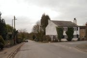
Robin Hood: The junction of Robin Hood Lane with High Moor Lane / David Dixon, 22 Feb. 2016, Creative Commons, via Geograph.
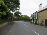
Robin Hood: The end of High Moor Lane / Richard Webb, 2 Jul. 2014, Creative Commons, via Geograph.
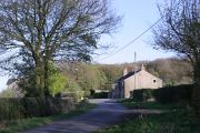
Junction of Moss Lane and Robin Hood Lane seen from Hill House Fold Lane / Chris Denny, 26 Apr. 2010, Creative Commons, via Geograph.
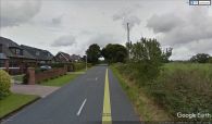
Robin Hood Lane / Google Earth Street View.


