
Robin Hood Inn (Smithfield): Difference between revisions
mNo edit summary |
m (Text replacement - "©" to "©") |
||
| (40 intermediate revisions by 2 users not shown) | |||
| Line 1: | Line 1: | ||
__NOTOC__ | __NOTOC__{{PlaceNamesItemTop|Lat=54.979635|Lon=-2.874770|AdministrativeDivision=Cumberland|Vicinity=In Smithfield, ''c.'' 10 km NNE of Carlisle|Type=Public house|Interest=Robin Hood name|Status=Extant|Demonym=|Riding=|GreaterLondon=|Year=1868|Aka=|Century=|Cluster1=|Cluster2=|Cluster3=|Image=Robin_Hood_Inn,_Smithfield_-_geograph.org.uk_-_283668.jpg|Postcards=|ExtraCat1=|ExtraCat2=|ExtraCat3=|ExtraCat4=|ExtraCat5=|ExtraLink1=|ExtraLink2=|ExtraLink3=|ExtraLink4=|ExtraLink5=|ExtraLinkName1=|ExtraLinkName2=|ExtraLinkName3=|ExtraLinkName4=|ExtraLinkName5=|GeopointPrefix=|GeopointSuffix=|StatusSuffix=|DatePrefix=|DateSuffix=}} | ||
{{ | {{#display_map:{{#var:Coords}}~{{#replace:{{PAGENAME}}|'|'}}|width=34%|enablefullscreen=yes}}<div class="pnMapLegend">The Robin Hood Inn.</div> | ||
[[File:{{#var:Image}}|thumb|right|500px|Robin Hood Inn, Smithfield / [https://en.wikipedia.org/wiki/Smithfield,_Cumbria#/media/File:Robin_Hood_Inn,_Smithfield_-_geograph.org.uk_-_283668.jpg Adrian Taylor, 2006; Creative Commons; Geograph.]]]<div class="no-img"> | |||
<p id="byline">By Henrik Thiil Nielsen, 2017-02-21. Revised by {{#realname:{{REVISIONUSER}}}}, {{REVISIONYEAR}}-{{REVISIONMONTH}}-{{REVISIONDAY2}}.</p> | |||
In Smithfield, ''c.'' 10 km NNE of Carlisle, is found the Robin Hood Inn, a.k.a. the Robin Hood. The earliest record of it that I have found so far is a 6" O.S. map of the area published in 1868, based on surveying carried out in 1864 (see Maps section below). It has been suggested that the present red-brick building dates from the 1890's,<ref>[http://www.geog.port.ac.uk/webmap/thelakes/html/lgaz/lk13506.htm Old Cumbria Gazetteer: Robin Hood Inn.]</ref> but it is perhaps more likely to have been built in 1904. The pub has an entranceway complete with columns, pediment and entablature. Into the tympanum is carved the dates "A. D. 17[18] – 1904" ("18" is partly erased and looks more like "16") while the entablature has the inscription "ROBIN HOOD INN" (see photos on this page). These presumably came from an older building, so very likely the pub dates back to 1718. I do not know whether the two inscriptions – year and name – are coeval and so cannot rule out the possibility that the pub originally operated under another name but was later renamed the Robin Hood Inn. It is quite likely, but not certain, that the Robin Hood dates back to 1718.{{PlaceNamesItemAllusionsAndRecords}} | |||
== Gazetteers == | |||
}} | |||
{{# | |||
[[File: | |||
<p id="byline">By Henrik Thiil Nielsen, 2017-02-21. Revised by {{#realname:{{REVISIONUSER}}}}, {{REVISIONYEAR}}-{{REVISIONMONTH}}-{{REVISIONDAY2}}.</p | |||
In Smithfield, ''c.'' 10 km NNE of Carlisle, is found the Robin Hood Inn, a.k.a. the Robin Hood. The earliest record of it that I have found so far is a 6" O.S. map of the area published in 1868, based on surveying carried out in 1864 (see Maps section below). It has been suggested that the present red-brick building dates from the 1890's,<ref>[http://www.geog.port.ac.uk/webmap/thelakes/html/lgaz/lk13506.htm Old Cumbria Gazetteer: Robin Hood Inn.]</ref> but it is perhaps more likely to have been built in 1904. The pub has an entranceway complete with columns, pediment and entablature. Into the tympanum is carved the dates "A. D. 17[18] – 1904" | |||
{{ | |||
* Not included in {{:Dobson, Richard Barrie 1976a}}, pp. 293-311. | * Not included in {{:Dobson, Richard Barrie 1976a}}, pp. 293-311. | ||
== Sources == | |||
* [http://www.geog.port.ac.uk/webmap/thelakes/html/lgaz/lk13506.htm Old Cumbria Gazetteer: Robin Hood Inn] | * [http://www.geog.port.ac.uk/webmap/thelakes/html/lgaz/lk13506.htm Old Cumbria Gazetteer: Robin Hood Inn] | ||
== Maps == | |||
* [http://maps.nls.uk/view/102340719#zoom=6&lat=3238&lon=2558&layers=BT 6" O.S. map ''Cumberland'' XI (1868; surveyed 1864)] | * [http://maps.nls.uk/view/102340719#zoom=6&lat=3238&lon=2558&layers=BT 6" O.S. map ''Cumberland'' XI (1868; surveyed 1864)] | ||
* [http://maps.nls.uk/geo/explore/#zoom=18&lat=54.9799&lon=-2.8755&layers=171&b=1 6" O.S. map ''Cumberland'' XI.SW (1901; surveyed 1899)] | * [http://maps.nls.uk/geo/explore/#zoom=18&lat=54.9799&lon=-2.8755&layers=171&b=1 6" O.S. map ''Cumberland'' XI.SW (1901; surveyed 1899)] | ||
| Line 36: | Line 14: | ||
* [http://maps.nls.uk/view/101089240#zoom=5&lat=3965&lon=2884&layers=BT 6" O.S. map ''Cumberland'' XI.SW (1951; surveyed 1945).] | * [http://maps.nls.uk/view/101089240#zoom=5&lat=3965&lon=2884&layers=BT 6" O.S. map ''Cumberland'' XI.SW (1951; surveyed 1945).] | ||
== Background == | |||
* [https://en.wikipedia.org/wiki/Pediment Wikipedia: Pediment] | * [https://en.wikipedia.org/wiki/Pediment Wikipedia: Pediment] | ||
* [https://en.wikipedia.org/wiki/Smithfield,_Cumbria Wikipedia: Smithfield, Cumbria.] | * [https://en.wikipedia.org/wiki/Smithfield,_Cumbria Wikipedia: Smithfield, Cumbria.] | ||
<!-- | <!--== Brief mention == | ||
* --> | * --> | ||
{{PlaceNamesItemAlsoSee}} | |||
== Notes == | |||
<references/> | <references/> | ||
</div> | </div> | ||
{{ | <div id="gallery"> | ||
{{ImageGalleryIntroduction}} | |||
<gallery widths="195px"> | <gallery widths="195px"> | ||
File:Robin_Hood_Inn,_Smithfield_-_geograph.org.uk_-_283668.jpg|thumb|right|500px|Robin Hood Inn, Smithfield / [https://en.wikipedia.org/wiki/Smithfield,_Cumbria#/media/File:Robin_Hood_Inn,_Smithfield_-_geograph.org.uk_-_283668.jpg Adrian Taylor, 2006; Creative Commons; Geograph.] | File:Robin_Hood_Inn,_Smithfield_-_geograph.org.uk_-_283668.jpg|thumb|right|500px|Robin Hood Inn, Smithfield / [https://en.wikipedia.org/wiki/Smithfield,_Cumbria#/media/File:Robin_Hood_Inn,_Smithfield_-_geograph.org.uk_-_283668.jpg Adrian Taylor, 2006; Creative Commons; Geograph.] | ||
File:Geograph-5069799-by-The-Carlisle-Kid.jpg|thumb|right|500px|Inscription above the entranceway / [http://www.geograph.org.uk/profile/61944 The Carlisle Kid; Creative Commons; Geograph] (click to enlarge). | File:Geograph-5069799-by-The-Carlisle-Kid.jpg|thumb|right|500px|Inscription above the entranceway / [http://www.geograph.org.uk/profile/61944 The Carlisle Kid; Creative Commons; Geograph] (click to enlarge). | ||
File:robin-hood-smithfield-sign-2006.jpg|thumb|right|500px|The inn sign / [http://www.geog.port.ac.uk/webmap/thelakes/html/lgaz/lk13506.htm Old Cumbria Gazet­teer: Robin Hood Inn; | File:robin-hood-smithfield-sign-2006.jpg|thumb|right|500px|The inn sign / [http://www.geog.port.ac.uk/webmap/thelakes/html/lgaz/lk13506.htm Old Cumbria Gazet­teer: Robin Hood Inn; © Martin & Jean Norgate: 2014.] | ||
</gallery> | </gallery> | ||
</div> | |||
{{PlaceNamesItemNavigation}} | |||
{{ | |||
Latest revision as of 11:51, 21 March 2021
| Locality | |
|---|---|
| Coordinate | 54.979635, -2.87477 |
| Adm. div. | Cumberland |
| Vicinity | In Smithfield, c. 10 km NNE of Carlisle |
| Type | Public house |
| Interest | Robin Hood name |
| Status | Extant |
| First Record | 1868 |

By Henrik Thiil Nielsen, 2017-02-21. Revised by Henrik Thiil Nielsen, 2021-03-21.
In Smithfield, c. 10 km NNE of Carlisle, is found the Robin Hood Inn, a.k.a. the Robin Hood. The earliest record of it that I have found so far is a 6" O.S. map of the area published in 1868, based on surveying carried out in 1864 (see Maps section below). It has been suggested that the present red-brick building dates from the 1890's,[1] but it is perhaps more likely to have been built in 1904. The pub has an entranceway complete with columns, pediment and entablature. Into the tympanum is carved the dates "A. D. 17[18] – 1904" ("18" is partly erased and looks more like "16") while the entablature has the inscription "ROBIN HOOD INN" (see photos on this page). These presumably came from an older building, so very likely the pub dates back to 1718. I do not know whether the two inscriptions – year and name – are coeval and so cannot rule out the possibility that the pub originally operated under another name but was later renamed the Robin Hood Inn. It is quite likely, but not certain, that the Robin Hood dates back to 1718.
Gazetteers
- Not included in Dobson, R. B., ed.; Taylor, J., ed. Rymes of Robyn Hood: an Introduction to the English Outlaw (London, 1976), pp. 293-311.
Sources
Maps
- 6" O.S. map Cumberland XI (1868; surveyed 1864)
- 6" O.S. map Cumberland XI.SW (1901; surveyed 1899)
- 6" O.S. map Cumberland XI.SW (1926; surveyed 1924)
- 6" O.S. map Cumberland XI.SW (1951; surveyed 1945).
Background
Also see
Notes
Image gallery
Click any image to display it in the lightbox, where you can navigate between images by clicking in the right or left side of the current image.
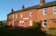
Robin Hood Inn, Smithfield / Adrian Taylor, 2006; Creative Commons; Geograph.

Inscription above the entranceway / The Carlisle Kid; Creative Commons; Geograph (click to enlarge).

