
Robin Hood Inn (Lambley): Difference between revisions
m (Text replacement - "ImgGalleryIntro" to "ImageGalleryIntroduction") |
m (Text replacement - "No Copy in NLS" to "No copy in NLS") |
||
| Line 12: | Line 12: | ||
== Maps == | == Maps == | ||
* [https://maps.nls.uk/view/115391972#zoom=4&lat=5650&lon=13978&layers=BT 25" O.S. map ''Nottinghamshire'' XXXVIII.8 (1884; surveyed 1882-83)] | * [https://maps.nls.uk/view/115391972#zoom=4&lat=5650&lon=13978&layers=BT 25" O.S. map ''Nottinghamshire'' XXXVIII.8 (1884; surveyed 1882-83)] | ||
* 25" O.S. map ''Nottinghamshire'' XXXVIII.8 (''c.'' 1900; rev. ''c.'' 1899). No | * 25" O.S. map ''Nottinghamshire'' XXXVIII.8 (''c.'' 1900; rev. ''c.'' 1899). No copy in NLS | ||
* [https://maps.nls.uk/geo/explore/#zoom=18&lat=53.0012&lon=-1.0604&layers=168&b=5 25" O.S. map ''Nottinghamshire'' XXXVIII.8 (1914; rev. 1913)] (georeferenced) | * [https://maps.nls.uk/geo/explore/#zoom=18&lat=53.0012&lon=-1.0604&layers=168&b=5 25" O.S. map ''Nottinghamshire'' XXXVIII.8 (1914; rev. 1913)] (georeferenced) | ||
* [https://maps.nls.uk/view/115391975#zoom=5&lat=5706&lon=13937&layers=BT 25" O.S. map ''Nottinghamshire'' XXXVIII.8 (1914; rev. 1913)] | * [https://maps.nls.uk/view/115391975#zoom=5&lat=5706&lon=13937&layers=BT 25" O.S. map ''Nottinghamshire'' XXXVIII.8 (1914; rev. 1913)] | ||
Revision as of 01:13, 13 February 2021
| Locality | |
|---|---|
| Coordinate | 53.001157, -1.059495 |
| Adm. div. | Nottinghamshire |
| Vicinity | 82 Main Street, Lambley |
| Type | Public house |
| Interest | Robin Hood name |
| Status | Extant |
| First Record | 1925 |
By Henrik Thiil Nielsen, 2013-08-07. Revised by Henrik Thiil Nielsen, 2021-02-13.
The Robin Hood Inn in Lambley is either not included on the early O.S. maps listed below or is labelled simply "P. H." Information on publicans for the years 1925-41 can be found at the Pub Wiki.[1]
Gazetteers
- Not included in Dobson, R. B., ed.; Taylor, J., ed. Rymes of Robyn Hood: an Introduction to the English Outlaw (London, 1976), pp. 293-311.
Sources
Maps
- 25" O.S. map Nottinghamshire XXXVIII.8 (1884; surveyed 1882-83)
- 25" O.S. map Nottinghamshire XXXVIII.8 (c. 1900; rev. c. 1899). No copy in NLS
- 25" O.S. map Nottinghamshire XXXVIII.8 (1914; rev. 1913) (georeferenced)
- 25" O.S. map Nottinghamshire XXXVIII.8 (1914; rev. 1913)
- 6" O.S. map Nottinghamshire XXXVIII.NE (1885; surveyed 1878-83)
- 6" O.S. map Nottinghamshire XXXVIII.NE (1901; rev. 1899) (georeferenced)
- 6" O.S. map Nottinghamshire XXXVIII.NE (1901; rev. 1899)
- 6" O.S. map Nottinghamshire XXXVIII.NE (1919; rev. 1913)
- 6" O.S. map Nottinghamshire XXXVIII.NE (c. 1950; rev. 1944)
- 6" O.S. map Nottinghamshire XXXVIII.NE (1952; rev. 1950).
Background
Also see
Notes
Image gallery
Click any image to display it in the lightbox, where you can navigate between images by clicking in the right or left side of the current image.

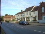
The Robin Hood Inn from Orchard Rise / Alan Murray-Rust, 17 Oct. 2008, Creative Commons, via Geograph.
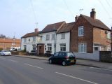
The Robin Hood Inn on Main Street, part of the Conservation Area of Lambley / Alan Murray-Rust, 17 Oct. 2008, Creative Commons, via Geograph.
The Robin Hood and Little John, Lambley / Al Partington, 28 Mar. 2007, Creative Commons, via Geograph.


