
Robin Hood Inn (Lambley): Difference between revisions
From International Robin Hood Bibliography
m (Text replacement - "|service=leaflet|" to "|") |
m (Text replacement - "AdmDiv" to "AdministrativeDivision") |
||
| Line 1: | Line 1: | ||
__NOTOC__{{PnItemTop|Lat=53.001157|Lon=-1.059495| | __NOTOC__{{PnItemTop|Lat=53.001157|Lon=-1.059495|AdministrativeDivision=Nottinghamshire|Vicinity=82 Main Street, Lambley|Type=Public house|Interest=Robin Hood name|Status=Extant|Demonym=|Riding=|GreaterLondon=|Year=1925|Aka=|Century=|Cluster1=|Cluster2=|Cluster3=|Image=|Postcards=|ExtraCat1=|ExtraCat2=|ExtraCat3=|ExtraCat4=|ExtraCat5=|ExtraLink1=|ExtraLink2=|ExtraLink3=|ExtraLink4=|ExtraLink5=|ExtraLinkName1=|ExtraLinkName2=|ExtraLinkName3=|ExtraLinkName4=|ExtraLinkName5=|GeopointPrefix=|GeopointSuffix=|StatusSuffix=|DatePrefix=|DateSuffix=}} | ||
{{#display_map:{{#var:Coords}}~{{#replace:{{PAGENAME}}|'|'}}|width=34%|enablefullscreen=yes}}<div class="pnMapLegend">The Robin Hood Inn.</div><div class="no-img"> | {{#display_map:{{#var:Coords}}~{{#replace:{{PAGENAME}}|'|'}}|width=34%|enablefullscreen=yes}}<div class="pnMapLegend">The Robin Hood Inn.</div><div class="no-img"> | ||
<p id="byline">By Henrik Thiil Nielsen, 2013-08-07. Revised by {{#realname:{{REVISIONUSER}}}}, {{REVISIONYEAR}}-{{REVISIONMONTH}}-{{REVISIONDAY2}}.</p> | <p id="byline">By Henrik Thiil Nielsen, 2013-08-07. Revised by {{#realname:{{REVISIONUSER}}}}, {{REVISIONYEAR}}-{{REVISIONMONTH}}-{{REVISIONDAY2}}.</p> | ||
Revision as of 21:27, 5 January 2021
The Robin Hood Inn.
By Henrik Thiil Nielsen, 2013-08-07. Revised by Henrik Thiil Nielsen, 2021-01-05.
The Robin Hood Inn in Lambley is either not included on the early O.S. maps listed below or is labelled simply "P. H." Information on publicans for the years 1925-41 can be found at the Pub Wiki.[1]Template:PnItemQry
Gazetteers
- Not included in Dobson, R. B., ed.; Taylor, J., ed. Rymes of Robyn Hood: an Introduction to the English Outlaw (London, 1976), pp. 293-311.
Sources
Maps
- 25" O.S. map Nottinghamshire XXXVIII.8 (1884; surveyed 1882-83)
- 25" O.S. map Nottinghamshire XXXVIII.8 (c. 1900; rev. c. 1899). No Copy in NLS
- 25" O.S. map Nottinghamshire XXXVIII.8 (1914; rev. 1913) (georeferenced)
- 25" O.S. map Nottinghamshire XXXVIII.8 (1914; rev. 1913)
- 6" O.S. map Nottinghamshire XXXVIII.NE (1885; surveyed 1878-83)
- 6" O.S. map Nottinghamshire XXXVIII.NE (1901; rev. 1899) (georeferenced)
- 6" O.S. map Nottinghamshire XXXVIII.NE (1901; rev. 1899)
- 6" O.S. map Nottinghamshire XXXVIII.NE (1919; rev. 1913)
- 6" O.S. map Nottinghamshire XXXVIII.NE (c. 1950; rev. 1944)
- 6" O.S. map Nottinghamshire XXXVIII.NE (1952; rev. 1950).
Background
Notes
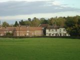
The Robin Hood Inn from Orchard Rise / Alan Murray-Rust, 17 Oct. 2008, Creative Commons, via Geograph.
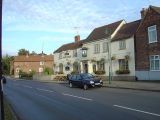
The Robin Hood Inn on Main Street, part of the Conservation Area of Lambley / Alan Murray-Rust, 17 Oct. 2008, Creative Commons, via Geograph.
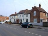
The Robin Hood and Little John, Lambley / Al Partington, 28 Mar. 2007, Creative Commons, via Geograph.


