
Robin Hood Inn (Lambley): Difference between revisions
From International Robin Hood Bibliography
mNo edit summary |
mNo edit summary |
||
| Line 30: | Line 30: | ||
{{ImgGalleryIntro}} | {{ImgGalleryIntro}} | ||
<gallery widths="195px"> | <gallery widths="195px"> | ||
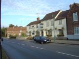
geograph-1014412-by-Alan-Murray-Rust.jpg|The Robin Hood Inn from Orchard Rise / [Alan Murray-Rust, 17 Oct. 2008, Creative Commons, via Geograph.] | geograph-1014412-by-Alan-Murray-Rust.jpg|The Robin Hood Inn from Orchard Rise / [https://www.geograph.org.uk/photo/1014412 Alan Murray-Rust, 17 Oct. 2008, Creative Commons, via Geograph.] | ||
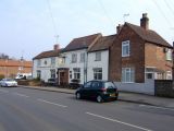
geograph-1014439-by-Alan-Murray-Rust.jpg|The Robin Hood Inn on Main Street, part of the Conservation Area of Lambley / [Alan Murray-Rust, 17 Oct. 2008, Creative Commons, via Geograph.] | geograph-1014439-by-Alan-Murray-Rust.jpg|The Robin Hood Inn on Main Street, part of the Conservation Area of Lambley / [https://www.geograph.org.uk/photo/1014439 Alan Murray-Rust, 17 Oct. 2008, Creative Commons, via Geograph.] | ||
geograph-386335-by-al-partington.jpg|The Robin Hood and Little John, Lambley / [Al Partington, 28 Mar. 2007, Creative Commons, via Geograph.] | geograph-386335-by-al-partington.jpg|The Robin Hood and Little John, Lambley / [https://www.geograph.org.uk/photo/386335 Al Partington, 28 Mar. 2007, Creative Commons, via Geograph.] | ||
</gallery> | </gallery> | ||
</div> | </div> | ||
{{PnItemNav}} | {{PnItemNav}} | ||
Revision as of 14:01, 9 October 2020
The Robin Hood Inn.
By Henrik Thiil Nielsen, 2013-08-07. Revised by Henrik Thiil Nielsen, 2020-10-09.
The Robin Hood Inn in Lambley is either not included on the early O.S. maps listed below or is labelled simply "P. H." Information on publicans for the years 1925-41 can be found at UK Pub History.[1]Template:PnItemQry
Gazetteers
- Not included in Dobson, R. B., ed.; Taylor, J., ed. Rymes of Robyn Hood: an Introduction to the English Outlaw (London, 1976), pp. 293-311.
Sources
Maps
- 25" O.S. map Nottinghamshire XXXVIII.8 (1884; surveyed 1882-83)
- 25" O.S. map Nottinghamshire XXXVIII.8 (c. 1900; rev. c. 1899). No Copy in NLS
- 25" O.S. map Nottinghamshire XXXVIII.8 (1914; rev. 1913) (georeferenced)
- 25" O.S. map Nottinghamshire XXXVIII.8 (1914; rev. 1913)
- 6" O.S. map Nottinghamshire XXXVIII.NE (1885; surveyed 1878-83)
- 6" O.S. map Nottinghamshire XXXVIII.NE (1901; rev. 1899) (georeferenced)
- 6" O.S. map Nottinghamshire XXXVIII.NE (1901; rev. 1899)
- 6" O.S. map Nottinghamshire XXXVIII.NE (1919; rev. 1913)
- 6" O.S. map Nottinghamshire XXXVIII.NE (c. 1950; rev. 1944)
- 6" O.S. map Nottinghamshire XXXVIII.NE (1952; rev. 1950).
Notes

The Robin Hood Inn from Orchard Rise / Alan Murray-Rust, 17 Oct. 2008, Creative Commons, via Geograph.
The Robin Hood Inn on Main Street, part of the Conservation Area of Lambley / Alan Murray-Rust, 17 Oct. 2008, Creative Commons, via Geograph.
The Robin Hood and Little John, Lambley / Al Partington, 28 Mar. 2007, Creative Commons, via Geograph.


