
Robin Hood Inn (Hartshill): Difference between revisions
m (Text replacement - "Creative Commons via Geograph" to "Creative Commons, via Geograph") |
m (Text replacement - "UK Pub History" to "Pub History") |
||
| (18 intermediate revisions by 2 users not shown) | |||
| Line 1: | Line 1: | ||
__NOTOC__{{ | __NOTOC__{{PlaceNamesItemTop|Lat=53.008966|Lon=-2.203084|AdministrativeDivision=Staffordshire|Vicinity=321 Hartshill Road, Stoke-on-Trent|Type=Public house|Interest=Robin Hood name|Status=Extant|Demonym=|Riding=|GreaterLondon=|Year=1912|Aka=|Century=|Cluster1=|Cluster2=|Cluster3=|Image=geograph-4991217-by-JThomas.jpg|Postcards=|ExtraCat1=|ExtraCat2=|ExtraCat3=|ExtraCat4=|ExtraCat5=|ExtraLink1=|ExtraLink2=|ExtraLink3=|ExtraLink4=|ExtraLink5=|ExtraLinkName1=|ExtraLinkName2=|ExtraLinkName3=|ExtraLinkName4=|ExtraLinkName5=|GeopointPrefix=|GeopointSuffix=|StatusSuffix=|DatePrefix=|DateSuffix=}} | ||
{{#display_map:{{#var:Coords}}~{{#replace:{{PAGENAME}}|'|'}}|width=34% | {{#display_map:{{#var:Coords}}~{{#replace:{{PAGENAME}}|'|'}}|width=34%|enablefullscreen=yes}}<div class="pnMapLegend">The Robin Hood Inn.</div> | ||
[[File:{{#var: | [[File:{{#var:Image}}|thumb|right|500px|The Robin Hood, Hartshill on Hartshill Road (A52) / [http://www.geograph.org.uk/photo/4991217 J. Thomas, 11 Jun. 2016, Creative Commons, via Geograph.]]]<div class="no-img"> | ||
<p id="byline">By Henrik Thiil Nielsen, 2013-08-07. Revised by {{#realname:{{REVISIONUSER}}}}, {{REVISIONYEAR}}-{{REVISIONMONTH}}-{{REVISIONDAY2}}.</p> | <p id="byline">By Henrik Thiil Nielsen, 2013-08-07. Revised by {{#realname:{{REVISIONUSER}}}}, {{REVISIONYEAR}}-{{REVISIONMONTH}}-{{REVISIONDAY2}}.</p> | ||
The Robin Hood on 321 Hartshill Road, Hartshill, Stoke-on-Trent, was in existence by 1912. Information on publicans for the years 1912-40 can be found at Pub History,<ref>[https://pubhistory.co.uk//Staffordshire/Stoke/RobinHood.shtml Pub History: Robin Hood, 409 Hartshill road, Stoke on Trent, Staffordshire]</ref> where it is listed with the address 409 Hartshill Road. If this was ever the case, house numbering must have changed or the pub must have moved, for it is now at 321 Hartshill Road.<ref>According to Google Earth as of 24 Oct. 2018.</ref>{{PlaceNamesItemAllusionsAndRecords}} | |||
The Robin Hood on 321 Hartshill Road, Hartshill, Stoke-on-Trent, was in existence by 1912. Information on publicans for the years 1912-40 can be found at | |||
== Gazetteers == | == Gazetteers == | ||
| Line 10: | Line 9: | ||
== Sources == | == Sources == | ||
* [https://pubhistory.co.uk//Staffordshire/Stoke/RobinHood.shtml | * [https://pubhistory.co.uk//Staffordshire/Stoke/RobinHood.shtml Pub History: Robin Hood, 409 Hartshill road, Stoke on Trent, Staffordshire.] | ||
== Maps == | == Maps == | ||
* 25" O.S. map ''Staffordshire'' XVIII.1 (''c.'' 1878; rev. ''c.'' 1877). No | * 25" O.S. map ''Staffordshire'' XVIII.1 (''c.'' 1878; rev. ''c.'' 1877). No copy in NLS | ||
* [https://maps.nls.uk/geo/explore/#zoom=19&lat=53.0090&lon=-2.2035&layers=168&b=5 25" O.S. map ''Staffordshire'' XVIII.1 (1900; rev. 1898)] (georeferenced) | * [https://maps.nls.uk/geo/explore/#zoom=19&lat=53.0090&lon=-2.2035&layers=168&b=5 25" O.S. map ''Staffordshire'' XVIII.1 (1900; rev. 1898)] (georeferenced) | ||
* [https://maps.nls.uk/view/115471095#zoom=5&lat=4217&lon=2018&layers=BT 25" O.S. map ''Staffordshire'' XVIII.1 (1900; rev. 1898)] | * [https://maps.nls.uk/view/115471095#zoom=5&lat=4217&lon=2018&layers=BT 25" O.S. map ''Staffordshire'' XVIII.1 (1900; rev. 1898)] | ||
| Line 24: | Line 23: | ||
* [https://maps.nls.uk/view/101596076#zoom=5&lat=4478&lon=1310&layers=BT 6" O.S. map ''Staffordshire'' XVIII.NW (''c.'' 1947; rev. 1937-38)] | * [https://maps.nls.uk/view/101596076#zoom=5&lat=4478&lon=1310&layers=BT 6" O.S. map ''Staffordshire'' XVIII.NW (''c.'' 1947; rev. 1937-38)] | ||
* [https://maps.nls.uk/view/101596073#zoom=5&lat=4578&lon=1379&layers=BT 6" O.S. map ''Staffordshire'' XVIII.NW (1951; rev. 1945-47).] | * [https://maps.nls.uk/view/101596073#zoom=5&lat=4578&lon=1379&layers=BT 6" O.S. map ''Staffordshire'' XVIII.NW (1951; rev. 1945-47).] | ||
{{ | {{PlaceNamesItemAlsoSee}} | ||
== Notes == | == Notes == | ||
<references/> | <references/> | ||
</div> | |||
< | <div id="gallery"> | ||
{{ | {{ImageGalleryIntroduction}} | ||
<gallery widths="195px"> | <gallery widths="195px"> | ||
geograph-4991217-by-JThomas.jpg|The Robin Hood, Hartshill on Hartshill Road (A52) / [http://www.geograph.org.uk/photo/4991217 J. Thomas, 11 Jun. 2016, Creative Commons, via Geograph.] | geograph-4991217-by-JThomas.jpg|The Robin Hood, Hartshill on Hartshill Road (A52) / [http://www.geograph.org.uk/photo/4991217 J. Thomas, 11 Jun. 2016, Creative Commons, via Geograph.] | ||
| Line 37: | Line 37: | ||
geograph-4994751-by-JThomas.jpg|Sign of the Robin Hood, Hartshill / [http://www.geograph.org.uk/photo/4994751 J. Thomas, 11 Jun. 2016, Creative Commons, via Geograph.] | geograph-4994751-by-JThomas.jpg|Sign of the Robin Hood, Hartshill / [http://www.geograph.org.uk/photo/4994751 J. Thomas, 11 Jun. 2016, Creative Commons, via Geograph.] | ||
</gallery> | </gallery> | ||
</div> | |||
{{ | {{PlaceNamesItemNavigation}} | ||
Latest revision as of 15:32, 5 May 2022
| Locality | |
|---|---|
| Coordinate | 53.008966, -2.203084 |
| Adm. div. | Staffordshire |
| Vicinity | 321 Hartshill Road, Stoke-on-Trent |
| Type | Public house |
| Interest | Robin Hood name |
| Status | Extant |
| First Record | 1912 |

By Henrik Thiil Nielsen, 2013-08-07. Revised by Henrik Thiil Nielsen, 2022-05-05.
The Robin Hood on 321 Hartshill Road, Hartshill, Stoke-on-Trent, was in existence by 1912. Information on publicans for the years 1912-40 can be found at Pub History,[1] where it is listed with the address 409 Hartshill Road. If this was ever the case, house numbering must have changed or the pub must have moved, for it is now at 321 Hartshill Road.[2]
Gazetteers
- Not included in Dobson, R. B., ed.; Taylor, J., ed. Rymes of Robyn Hood: an Introduction to the English Outlaw (London, 1976), pp. 293-311.
Sources
Maps
- 25" O.S. map Staffordshire XVIII.1 (c. 1878; rev. c. 1877). No copy in NLS
- 25" O.S. map Staffordshire XVIII.1 (1900; rev. 1898) (georeferenced)
- 25" O.S. map Staffordshire XVIII.1 (1900; rev. 1898)
- 25" O.S. map Staffordshire XVIII.1 (1924; rev. 1922-23)
- 25" O.S. map Staffordshire XVIII.1 (1940; rev. 1937)
- 6" O.S. map Staffordshire XVIII.NW (1889; surveyed 1866-77)
- 6" O.S. map Staffordshire XVIII.NW (1900; rev. 1898) (georeferenced)
- 6" O.S. map Staffordshire XVIII.NW (1900; rev. 1898)
- 6" O.S. map Staffordshire XVIII.NW (1925; rev. 1922-23)
- 6" O.S. map Staffordshire XVIII.NW (c. 1947; rev. 1937-38)
- 6" O.S. map Staffordshire XVIII.NW (1951; rev. 1945-47).
Also see
Notes
- ↑ Pub History: Robin Hood, 409 Hartshill road, Stoke on Trent, Staffordshire
- ↑ According to Google Earth as of 24 Oct. 2018.
Image gallery
Click any image to display it in the lightbox, where you can navigate between images by clicking in the right or left side of the current image.
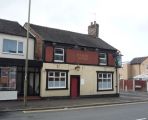
The Robin Hood, Hartshill on Hartshill Road (A52) / J. Thomas, 11 Jun. 2016, Creative Commons, via Geograph.
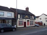
The Robin Hood, Hartshill / Geoff Pick, 24 Jan. 2009, Creative Commons, via Geograph.
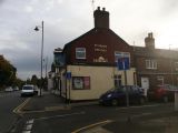
Hartshill: The Robin Hood / Jonathan Hutchins, 20 Oct. 2015, Creative Commons, via Geograph.
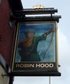
Sign of the Robin Hood, Hartshill / J. Thomas, 11 Jun. 2016, Creative Commons, via Geograph.


