
Robin Hood Inn (East Wallhouses): Difference between revisions
mNo edit summary |
m (Text replacement - "* 25" map" to "* 25" O.S. map") |
||
| (23 intermediate revisions by 2 users not shown) | |||
| Line 1: | Line 1: | ||
__NOTOC__{{ | __NOTOC__{{PlaceNamesItemTop|Lat=55.009937|Lon=-1.923518|AdministrativeDivision=Northumberland|Vicinity=West Military Road (B6318), East Wallhouses|Type=Public house|Interest=Robin Hood name|Status=Extant|Demonym=|Riding=|GreaterLondon=|Year=|Aka=|Century=|Cluster1=|Cluster2=|Cluster3=|Image=geograph-100459-by-Chris-Tweedy.jpg|Postcards=|ExtraCat1=|ExtraCat2=|ExtraCat3=|ExtraCat4=|ExtraCat5=|ExtraLink1=|ExtraLink2=|ExtraLink3=|ExtraLink4=|ExtraLink5=|ExtraLinkName1=|ExtraLinkName2=|ExtraLinkName3=|ExtraLinkName4=|ExtraLinkName5=|GeopointPrefix=|GeopointSuffix=|StatusSuffix=|DatePrefix=|DateSuffix=}} | ||
{{#display_map:{{#var:Coords}}~{{#replace:{{PAGENAME}}|'|'}}|width=34%}}<div class="pnMapLegend">The Robin hood Inn.</div> | {{#display_map:{{#var:Coords}}~{{#replace:{{PAGENAME}}|'|'}}|width=34%|enablefullscreen=yes}}<div class="pnMapLegend">The Robin hood Inn.</div><div class="no-img"> | ||
<p id="byline">By Henrik Thiil Nielsen, 2013-08-07. Revised by {{#realname:{{REVISIONUSER}}}}, {{REVISIONYEAR}}-{{REVISIONMONTH}}-{{REVISIONDAY2}}.</p> | <p id="byline">By Henrik Thiil Nielsen, 2013-08-07. Revised by {{#realname:{{REVISIONUSER}}}}, {{REVISIONYEAR}}-{{REVISIONMONTH}}-{{REVISIONDAY2}}.</p> | ||
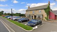
Still going strong, the Robin Hood Inn on West Military Road (B6318), East Wallhouses, was in existence by 1864. | |||
The inn is included on a 6" map of the area published 1864 and based on a survey carried out 1860–61 (see Maps below).{{PlaceNamesItemAllusionsAndRecords}} | |||
== Gazetteers == | |||
* Not included in {{:Dobson, Richard Barrie 1976a}}, pp. 293-311.<!-- | |||
== Sources ==--> | |||
== Maps == | |||
* 25" O.S. map ''Northumberland'' (''Old Series'') LXXXVI.11 (''c.'' 1864; surveyed ''c.'' 1860–61). No copy in NLS | |||
* [https://maps.nls.uk/geo/explore/#zoom=17&lat=55.01039&lon=-1.92471&layers=168&b=5 25" O.S. map ''Northumberland'' (''Old Series'') LXXXVI.11 (1896; rev. 1895)] (georeferenced) | |||
* [https://maps.nls.uk/view/132268292#zoom=6&lat=3476&lon=8901&layers=BT 25" O.S. map ''Northumberland'' (''Old Series'') LXXXVI.11 (1896; rev. 1895)] | |||
* [https://maps.nls.uk/view/132279875#zoom=5&lat=7483&lon=5717&layers=BT 25" O.S. map ''Northumberland'' (''New Series'') XCII.4 (1921; rev. 1920)] | |||
* [https://maps.nls.uk/view/102346455#zoom=6&lat=3779&lon=9484&layers=BT 6" O.S. map ''Northumberland'' LXXXVI (1864; surveyed 1860–61)] | |||
* [https://maps.nls.uk/geo/explore/#zoom=16&lat=55.01080&lon=-1.92653&layers=6&b=5 6" O.S. map ''Northumberland'' LXXXVI.SE (1898; rev. 1894–95)] (georeferenced) | |||
* [https://maps.nls.uk/view/101027457#zoom=4&lat=4159&lon=2580&layers=BT 6" O.S. map ''Northumberland'' LXXXVI.SE (1898; rev. 1894–95)] | |||
* [https://maps.nls.uk/view/102346671#zoom=6&lat=10183&lon=12554&layers=BT 6" O.S. map ''Northumberland'' nXCII (1924; rev. 1920)] | |||
* [https://maps.nls.uk/view/101028993#zoom=5&lat=5382&lon=5577&layers=BT 6" O.S. map ''Northumberland'' nXCII.NE (''c.'' 1949; rev. 1947).] | |||
== Background == | |||
* [https://www.facebook.com/RobinHoodMilitaryRoad/?ref=page_internal FaceBook: Robin Hood Inn] | |||
* [http://robinhoodinnhadrianswall.com The Robin Hood Inn: Hadrians Wall Country] (the inn's website). | |||
<!--== Notes == | |||
<references/>--> | |||
{{PlaceNamesItemAlsoSee}} | |||
</div> | |||
<div id="gallery"> | |||
{{ImageGalleryIntroduction}} | |||
<gallery widths="195px"> | |||
geograph-100459-by-Chris-Tweedy.jpg|The Robin Hood Inn: a mile or so west of Harlow Hill in North­umber­land / [https://m.geograph.org.uk/photo/100459 Chris Tweedy, 3 Jan. 2006; Creative Commons, via Geograph.] | |||
geograph-2892547-by-Ian-S.jpg|The Robin Hood / [https://m.geograph.org.uk/photo/2892547 Ian S., 4 Apr. 2012; Creative Commons, via Geograph.] | |||
geograph-4012407-by-Alex-McGregor.jpg|Robin Hood / [https://m.geograph.org.uk/photo/4012407 Alex McGregor, 3 June 2014; Creative Commons, via Geograph.] | |||
geograph-2893563-by-Ian-S.jpg|The Robin Hood, East Wallhouses / [https://m.geograph.org.uk/photo/2893563 Ian S., 5 Apr. 2012; Creative Commons, via Geograph.] | |||
geograph-2599692-by-Mike-Quinn.jpg|The Robin Hood, East Wallhouses / [https://m.geograph.org.uk/photo/2599692 Mike Quinn, 13 Sep. 2011; Creative Commons, via Geograph.] | |||
geograph-4111961-by-Anthony-Parkes.jpg|Camping Ground behind The Robin Hood / [https://m.geograph.org.uk/photo/4111961 Anthony Parkes, 30 July 2014; Creative Commons, via Geograph.] | |||
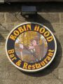
geograph-2599708-by-Mike-Quinn.jpg|Sign for The Robin Hood, East Wallhouses / [https://m.geograph.org.uk/photo/2599708 Mike Quinn, 13 Sep. 2011; Creative Commons, via Geograph.] | |||
geograph-2599710-by-Mike-Quinn.jpg|Sign No. 2 for The Robin Hood, East Wallhouses / [https://m.geograph.org.uk/photo/2599710 Mike Quinn, 13 Sep. 2011; Creative Commons, via Geograph.] | |||
geograph-2599713-by-Mike-Quinn.jpg|Sign No. 3 for The Robin Hood, East Wallhouses / [https://m.geograph.org.uk/photo/2599713 Mike Quinn, 13 Sep. 2011; Creative Commons, via Geograph.] | |||
geograph-2599714-by-Mike-Quinn.jpg|Sign No. 4 for The Robin Hood, East Wallhouses / [https://m.geograph.org.uk/photo/2599714 Mike Quinn, 13 Sep. 2011; Creative Commons, via Geograph.] | |||
robin-hood-inn-east-wallhouses-google-earth-street-view.jpg|Google Earth Street View. | |||
</gallery> | |||
</div> | </div> | ||
{{ | {{PlaceNamesItemNavigation}} | ||
Latest revision as of 16:43, 8 May 2022
| Locality | |
|---|---|
| Coordinate | 55.009937, -1.923518 |
| Adm. div. | Northumberland |
| Vicinity | West Military Road (B6318), East Wallhouses |
| Type | Public house |
| Interest | Robin Hood name |
| Status | Extant |
| First Record | |
By Henrik Thiil Nielsen, 2013-08-07. Revised by Henrik Thiil Nielsen, 2022-05-08.
Still going strong, the Robin Hood Inn on West Military Road (B6318), East Wallhouses, was in existence by 1864.
The inn is included on a 6" map of the area published 1864 and based on a survey carried out 1860–61 (see Maps below).
Gazetteers
- Not included in Dobson, R. B., ed.; Taylor, J., ed. Rymes of Robyn Hood: an Introduction to the English Outlaw (London, 1976), pp. 293-311.
Maps
- 25" O.S. map Northumberland (Old Series) LXXXVI.11 (c. 1864; surveyed c. 1860–61). No copy in NLS
- 25" O.S. map Northumberland (Old Series) LXXXVI.11 (1896; rev. 1895) (georeferenced)
- 25" O.S. map Northumberland (Old Series) LXXXVI.11 (1896; rev. 1895)
- 25" O.S. map Northumberland (New Series) XCII.4 (1921; rev. 1920)
- 6" O.S. map Northumberland LXXXVI (1864; surveyed 1860–61)
- 6" O.S. map Northumberland LXXXVI.SE (1898; rev. 1894–95) (georeferenced)
- 6" O.S. map Northumberland LXXXVI.SE (1898; rev. 1894–95)
- 6" O.S. map Northumberland nXCII (1924; rev. 1920)
- 6" O.S. map Northumberland nXCII.NE (c. 1949; rev. 1947).
Background
- FaceBook: Robin Hood Inn
- The Robin Hood Inn: Hadrians Wall Country (the inn's website).
Also see
Image gallery
Click any image to display it in the lightbox, where you can navigate between images by clicking in the right or left side of the current image.
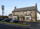
The Robin Hood Inn: a mile or so west of Harlow Hill in Northumberland / Chris Tweedy, 3 Jan. 2006; Creative Commons, via Geograph.
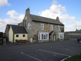
The Robin Hood / Ian S., 4 Apr. 2012; Creative Commons, via Geograph.
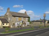
The Robin Hood, East Wallhouses / Ian S., 5 Apr. 2012; Creative Commons, via Geograph.
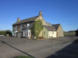
The Robin Hood, East Wallhouses / Mike Quinn, 13 Sep. 2011; Creative Commons, via Geograph.
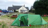
Camping Ground behind The Robin Hood / Anthony Parkes, 30 July 2014; Creative Commons, via Geograph.
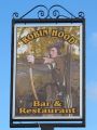
Sign for The Robin Hood, East Wallhouses / Mike Quinn, 13 Sep. 2011; Creative Commons, via Geograph.
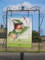
Sign No. 2 for The Robin Hood, East Wallhouses / Mike Quinn, 13 Sep. 2011; Creative Commons, via Geograph.
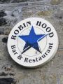
Sign No. 3 for The Robin Hood, East Wallhouses / Mike Quinn, 13 Sep. 2011; Creative Commons, via Geograph.
Sign No. 4 for The Robin Hood, East Wallhouses / Mike Quinn, 13 Sep. 2011; Creative Commons, via Geograph.
Google Earth Street View.


