
Robin Hood Inn (Castlemorton): Difference between revisions
From International Robin Hood Bibliography
mNo edit summary |
mNo edit summary |
||
| (15 intermediate revisions by the same user not shown) | |||
| Line 1: | Line 1: | ||
__NOTOC__{{ | __NOTOC__{{PlaceNamesItemTop|Lat=52.040187|Lon=-2.312349|AdministrativeDivision=Worcestershire|Vicinity=Gloucester Road, Castlemorton|Type=Public house|Interest=Robin Hood name|Status=Extant|Demonym=|Riding=|GreaterLondon=|Year=1885|Aka=Robin Hood|Century=|Cluster1=|Cluster2=|Cluster3=|Image=geograph-823117-by-Peter-Whatley.jpg|Postcards=|ExtraCat1=|ExtraCat2=|ExtraCat3=|ExtraCat4=|ExtraCat5=|GeopointPrefix=|GeopointSuffix=|StatusSuffix=|DatePrefix=|DateSuffix=}} | ||
{{#display_map:{{#var:Coords}}~{{#replace:{{PAGENAME}}|'|'}}|zoom=|width=34%}}<div class="pnMapLegend">The Robin Hood Inn.</div> | {{#display_map:{{#var:Coords}}~{{#replace:{{PAGENAME}}|'|'}}|zoom=|width=34%|enablefullscreen=yes}}<div class="pnMapLegend">The Robin Hood Inn.</div> | ||
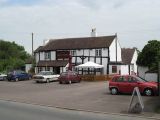
[[File:{{#var:Image}}|thumb|right|500px|The Robin Hood / [https://m.geograph.org.uk/photo/823117 Peter Whatley, 30 May 2008, Creative Commons, via Geograph.]]] | |||
<div class="no-img"> | |||
<p id="byline">By Henrik Thiil Nielsen, 2013-08-07. Revised by {{#realname:{{REVISIONUSER}}}}, {{REVISIONYEAR}}-{{REVISIONMONTH}}-{{REVISIONDAY2}}.</p> | <p id="byline">By Henrik Thiil Nielsen, 2013-08-07. Revised by {{#realname:{{REVISIONUSER}}}}, {{REVISIONYEAR}}-{{REVISIONMONTH}}-{{REVISIONDAY2}}.</p> | ||
The Robin Hood Inn on Gloucester Road, Castlemorton, was in existence by 1885 and is still in business. | |||
The earliest references known to IRHB are 25" and 6" Ordnance Survey maps of the area published in 1885, based on a survey carried out in 1884 (see Maps below). | |||
{{PlaceNamesItemAllusionsAndRecords}} | |||
== Gazetteers == | |||
* Not included in {{:Dobson, Richard Barrie 1976a}}, pp. 293-311. | |||
== Sources == | |||
* [https://www.facebook.com/The-Robin-Hood-Castlemorton-Malvern-1391018187834971 FaceBook: The Robin Hood Castlemorton Malvern.] | |||
== Maps == | |||
* [https://maps.nls.uk/view/120901762#zoom=5&lat=4932&lon=5965&layers=BT 25" O.S. map ''Worcestershire'' XLVII.13 (1885; surveyed 1884)] | |||
* [https://maps.nls.uk/geo/explore/#zoom=17&lat=52.04047&lon=-2.31327&layers=168&b=5 25" O.S. map ''Worcestershire'' XLVII.13 (1904; rev. 1903)] (georeferenced) | |||
* [https://maps.nls.uk/view/120901765#zoom=5&lat=5184&lon=5813&layers=BT 25" O.S. map ''Worcestershire'' XLVII.13 (1904; rev. 1903)] | |||
* [https://maps.nls.uk/view/120901768#zoom=5&lat=4901&lon=6304&layers=BT 25" O.S. map ''Worcestershire'' XLVII.13 (1927; rev. 1926).] | |||
* [https://maps.nls.uk/view/101586763#zoom=4&lat=2351&lon=2177&layers=BT 6" O.S. map ''Worcestershire'' Sheet XLVII.SW (1930; rev. 1926)] | |||
* [https://maps.nls.uk/view/101586766#zoom=4&lat=2142&lon=2011&layers=BT 6" O.S. map ''Worcestershire'' Sheet XLVII.SW (1905; rev. 1903)] | |||
* [https://maps.nls.uk/geo/explore/#zoom=17&lat=52.04066&lon=-2.31368&layers=6&b=5 6" O.S. map ''Worcestershire'' Sheet XLVII.SW (1885; surveyed 1884)] (georeferenced) | |||
* [https://maps.nls.uk/view/101586769#zoom=5&lat=2083&lon=2502&layers=BT 6" O.S. map ''Worcestershire'' Sheet XLVII.SW (1885; surveyed 1884)] | |||
{{PlaceNamesItemAlsoSee}} | |||
</div> | |||
<div id="gallery"> | |||
{{ImageGalleryIntroduction}} | |||
<gallery widths="195px"> | |||
geograph-823117-by-Peter-Whatley.jpg|The Robin Hood / [https://m.geograph.org.uk/photo/823117 Peter Whatley, 30 May 2008, Creative Commons, via Geograph.] | |||
robin-hood-inn-castlemorton-google-earth-street-view.jpg|The Robin Hood / Google Earth Street View. | |||
</gallery> | |||
</div> | </div> | ||
{{ | {{PlaceNamesItemNavigation}} | ||
Latest revision as of 18:54, 4 February 2022
| Locality | |
|---|---|
| Coordinate | 52.040187, -2.312349 |
| Adm. div. | Worcestershire |
| Vicinity | Gloucester Road, Castlemorton |
| Type | Public house |
| Interest | Robin Hood name |
| Status | Extant |
| First Record | 1885 |
| A.k.a. | Robin Hood |
The Robin Hood Inn.

The Robin Hood / Peter Whatley, 30 May 2008, Creative Commons, via Geograph.
By Henrik Thiil Nielsen, 2013-08-07. Revised by Henrik Thiil Nielsen, 2022-02-04.
The Robin Hood Inn on Gloucester Road, Castlemorton, was in existence by 1885 and is still in business.
The earliest references known to IRHB are 25" and 6" Ordnance Survey maps of the area published in 1885, based on a survey carried out in 1884 (see Maps below).
Gazetteers
- Not included in Dobson, R. B., ed.; Taylor, J., ed. Rymes of Robyn Hood: an Introduction to the English Outlaw (London, 1976), pp. 293-311.
Sources
Maps
- 25" O.S. map Worcestershire XLVII.13 (1885; surveyed 1884)
- 25" O.S. map Worcestershire XLVII.13 (1904; rev. 1903) (georeferenced)
- 25" O.S. map Worcestershire XLVII.13 (1904; rev. 1903)
- 25" O.S. map Worcestershire XLVII.13 (1927; rev. 1926).
- 6" O.S. map Worcestershire Sheet XLVII.SW (1930; rev. 1926)
- 6" O.S. map Worcestershire Sheet XLVII.SW (1905; rev. 1903)
- 6" O.S. map Worcestershire Sheet XLVII.SW (1885; surveyed 1884) (georeferenced)
- 6" O.S. map Worcestershire Sheet XLVII.SW (1885; surveyed 1884)
Also see
Image gallery
Click any image to display it in the lightbox, where you can navigate between images by clicking in the right or left side of the current image.
The Robin Hood / Peter Whatley, 30 May 2008, Creative Commons, via Geograph.
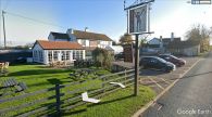
The Robin Hood / Google Earth Street View.
