
Robin Hood Hotel (Kingston-upon-Thames): Difference between revisions
From International Robin Hood Bibliography
m (Text replacement - "|service=leaflet}}" to "|service=leaflet|enablefullscreen=yes}}") |
rh>Henryfunk mNo edit summary |
||
| Line 33: | Line 33: | ||
== Notes == | == Notes == | ||
<references/> | <references/> | ||
</div> | |||
< | <div id="gallery"> | ||
{{ImgGalleryIntro}} | {{ImgGalleryIntro}} | ||
<gallery widths="195px"> | <gallery widths="195px"> | ||
| Line 42: | Line 43: | ||
robin-hood-hotel-kingston-vale-google-earth-street-view.jpg|Site of Robin Hood Hotel / Google Earth Street View. | robin-hood-hotel-kingston-vale-google-earth-street-view.jpg|Site of Robin Hood Hotel / Google Earth Street View. | ||
</gallery> | </gallery> | ||
</div> | |||
{{PnItemNav}} | {{PnItemNav}} | ||
Revision as of 11:58, 15 May 2020
Robin Hood Hotel (Kingston-upon-Thames).
By Henrik Thiil Nielsen, 2018-01-13. Revised by 3.145.93.221, 2020-05-15.
The Robin Hood Hotel a.k.a. the Robin Hood Inn was located on the corner of Robin Hood Lane and Kingston Vale (A308). Data on publicans from trade directories, census records etc. for the years 1855-1918 can be found at UK Pub History.[1] The earliest map to include the hotel is perhaps a 6" O.S. map of the area published in 1874 (see Maps section below).Template:PnItemQry
Gazetteers
- Not included in Dobson, R. B., ed.; Taylor, J., ed. Rymes of Robyn Hood: an Introduction to the English Outlaw (London, 1976), pp. 293-311.
Sources
Maps
- 25" O.S. map Surrey VII.9 (c. 1868; surveyed c. 1865-67). No Copy in NLS
- 25" O.S. map Surrey VII.9 (1897; rev. 1894)
- 25" O.S. map London (1915- Numbered sheets) VIII.14 (1916; rev. 1913) (georeferenced)
- 25" O.S. map Surrey VII.9 (1934; rev. 1911)
- 25" O.S. map Surrey VII.9 (1935; rev. 1933)
- 25" O.S. map Surrey VII.9 (1947; rev. 1940)
- 6" O.S. map Surrey VII (1874; surveyed 1865)
- 6" O.S. map Surrey VII.SW (1899; rev. 1893-95) (georeferenced)
- 6" O.S. map Surrey VII.SW (1899; rev. 1893-95) (georeferenced)
- 6" O.S. map Surrey VII.SW (1899; rev. 1893-95)
- 6" O.S. map Surrey VII.SW (1920; rev. 1911)
- 6" O.S. map Surrey VII.SW (c. 1933; rev. 1911)
- 6" O.S. map Surrey VII.SW (1936; rev. 1932-33)
- 6" O.S. map Surrey VII.SW (c. 1944; rev. 1938)
- 6" O.S. map Surrey VII.SW (c. 1946; rev. 1938).
Notes
- ↑ UK Pub History: Robin Hood, Kingston Vale, Putney; UK Pub History: Robin Hood, Kingston Vale, Kingston on Thames, Surrey; London (South) 1896 Suburban Publicans directory listing - R.
- ↑ Also see UK Pub History: Robin Hood, Kingston Vale, Kingston on Thames, Surrey; London (South) 1896 Suburban Publicans directory listing - R.
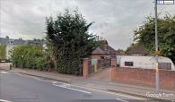
Site of Robin Hood Hotel / Google Earth Street View.


