
Robin Hood Hay (Agden): Difference between revisions
m (Text replacement - "(paid subscription required)" to "(subscription required)") |
m (Text replacement - "* 25" map" to "* 25" O.S. map") |
||
| (25 intermediate revisions by the same user not shown) | |||
| Line 1: | Line 1: | ||
__NOTOC__{{ | __NOTOC__{{PlaceNamesItemTop|Lat=53.3637|Lon=-2.4164|AdministrativeDivision=Cheshire|Vicinity=Immediately W of reddy Lane and S of M56; Agden in parish of Rostherne|Type=Area|Interest=Robin Hood name|Status=Defunct|Demonym=|Riding=|GreaterLondon=|Year=1848|Aka=|Century=|Cluster1=Agden|Cluster2=|Cluster3=|Image=robin-hood-hay-agden-google-earth-street-view.jpg|Postcards=|ExtraCat1=Places named Robin Hood's Close|ExtraCat2=|ExtraCat3=|ExtraCat4=|ExtraCat5=|ExtraLink1=|ExtraLink2=|ExtraLink3=|ExtraLink4=|ExtraLink5=|ExtraLinkName1=|ExtraLinkName2=|ExtraLinkName3=|ExtraLinkName4=|ExtraLinkName5=|GeopointPrefix=|GeopointSuffix=|StatusSuffix=?|DatePrefix=|DateSuffix=}} | ||
{{#display_map:{{#var:Coords}}~{{#replace:{{PAGENAME}}|'|'}}|width=34%}}<div class="pnMapLegend"> | {{#display_map:{{#var:Coords}}~{{#replace:{{PAGENAME}}|'|'}}|width=34%|enablefullscreen=yes}}<div class="pnMapLegend">The (former?) Robin Hood Hay in Agden.</div> | ||
[[File:{{#var:Image}}|thumb|right|500px|Looking NW from Reddy Lane. This area was formerly known as Robin Hood Hay / Google Earth Street View.]]<div class="no-img"> | |||
<p id="byline">By Henrik Thiil Nielsen, 2017-01-16. Revised by {{#realname:{{REVISIONUSER}}}}, {{REVISIONYEAR}}-{{REVISIONMONTH}}-{{REVISIONDAY2}}.</p> | <p id="byline">By Henrik Thiil Nielsen, 2017-01-16. Revised by {{#realname:{{REVISIONUSER}}}}, {{REVISIONYEAR}}-{{REVISIONMONTH}}-{{REVISIONDAY2}}.</p> | ||
In modern terms, Robin Hood Hay in Agden, Cheshire, was situated immediately northwest of Reddy Lane and mostly south of the M56. The field name occurs in the tithe award for Agden in the parish of Rostherne (1848). | |||
As of January 2017, Robin Hood Hay does not seem to be mentioned elsewhere on the World Wide Web. | A close is listed there under the name 'Robin Hood Hay', with Sir John Newdigate-Ludford-Chetwode, Baronet, as owner, Thomas Cross as occcupier, 'Meadow' as state of cultivation, and an area of 7 acres and 28 perches ({{AcresRoodsPerchesToM2|7|0|28}} m<sup>2</sup>).<ref>1848 tithe award for the township of Agden in the parish of Rostherne, online at the [https://www.thegenealogist.com Genealogist], Piece 05, sub-piece 006, Image 0004, #62 (£); accompanying map, online at the [https://www.thegenealogist.com Genealogist], Piece 05, sub-piece 006, Sub-Image 001, #62 (£).</ref> The field name is noted by John McNeal Dodgson in the English Place Name Society's survey of Cheshire. He does not cite any etymology for 'Hay', but this would seem more likely to be OE '''(ge)hæg''', 'enclosure', or OE '''hege''' ('a hedge, a fence) than '''hēg''', 'hay, mowing grass', since the latter is almost exclusively found as the first element of compound names.<ref>{{:Dodgson, John McNeal 1970a}}, vol. II, pp. 42, 43; see. vol. V, pt. I:ii, pp. 205-207 and 220 for the place-name elements; also see vol. V, pt. 1:ii, p. 401.</ref> | ||
At the northwest end of Robin Hood Hay was [[Little Robin Hood Hay (Agden)|Little Robin Hood Hay]]. Both ployts are roughly indicated on the adapeted map detail included in the image gallery below. As of January 2017, Robin Hood Hay does not seem to be mentioned elsewhere on the World Wide Web, so most likely the field name is defunct. | |||
<!--== Allusions == | <!--== Allusions == | ||
{{#ask:[[Category:Allusions (Robin Hood Hay, Agden)]]|format=embedded|embedformat=h3|columns=1|limit=1000|sort=Utitle}}--> | {{#ask:[[Category:Allusions (Robin Hood Hay, Agden)]]|format=embedded|embedformat=h3|columns=1|limit=1000|sort=Utitle}}--> | ||
== Gazetteers == | == Gazetteers == | ||
* Not included in {{:Dobson, Richard Barrie 1976a}}, pp. 293-311. | * Not included in {{:Dobson, Richard Barrie 1976a}}, pp. 293-311. | ||
== | |||
* {{:Dodgson, John McNeal 1970a}}, vol. II, p. 43; also see vol. V, pt. 1:ii, p. 401. | == MS sources == | ||
* 1848 tithe award for the township of Agden in the parish of Rostherne, online at the [https://www.thegenealogist.com Genealogist], Piece 05, sub-piece 006, Image 0004, #62 (£) | |||
* accompanying map, online at the [https://www.thegenealogist.com Genealogist], Piece 05, sub-piece 006, Sub-Image 001, #62 (£). | |||
== Printed sources == | |||
* {{:Dodgson, John McNeal 1970a}}, vol. II, p. 43; also see vol. V, pt. 1:ii, p. 401. | |||
== Maps == | == Maps == | ||
* -- | * 25" O.S. map ''Cheshire'' XVII.12 (''c.'' 1875; surveyed ''c.'' 1873). No copy in NLS] | ||
* [https://maps.nls.uk/geo/explore/#zoom=16&lat=53.36428&lon=-2.41921&layers=168&b=5 25" O.S. map ''Cheshire'' XVII.12 (1898; rev. 1897)] (georeferenced) | |||
== | * [https://maps.nls.uk/view/114581761#zoom=4&lat=2933&lon=7924&layers=BT 25" O.S. map ''Cheshire'' XVII.12 (1898; rev. 1897)] | ||
* [https:// | * [https://maps.nls.uk/view/114581764#zoom=4&lat=2958&lon=7923&layers=BT 25" O.S. map ''Cheshire'' XVII.12 (1910; rev. 1908)] | ||
{{ | * [https://maps.nls.uk/view/102341002#zoom=5&lat=3623&lon=13028&layers=BT 6" O.S. map ''Cheshire'' XVII (1882; surveyed 1873–76)] | ||
* [https://maps.nls.uk/geo/explore/#zoom=15&lat=53.36368&lon=-2.42358&layers=6&b=5 6" O.S. map ''Cheshire'' XVII.SE (1899; rev. 1897)] (georeferenced) | |||
* [https://maps.nls.uk/view/101598259#zoom=4&lat=4072&lon=6373&layers=BT 6" O.S. map ''Cheshire'' XVII.SE (1899; rev. 1897)] | |||
* [https://maps.nls.uk/view/101598253#zoom=4&lat=4149&lon=6501&layers=BT 6" O.S. map ''Cheshire'' XVII.SE (1911; rev. 1908)] | |||
* [https://maps.nls.uk/view/101598256#zoom=4&lat=4173&lon=6036&layers=BT 6" O.S. map ''Cheshire'' XVII.SE (''c.'' 1933; rev. 1908)] | |||
* [https://maps.nls.uk/view/102191200#zoom=4&lat=4227&lon=6037&layers=BT 6" O.S. map ''Cheshire'' XVII.SE (''c.'' 1936; rev. 1908)] | |||
* [https://maps.nls.uk/view/102191197#zoom=4&lat=4180&lon=6659&layers=BT 6" O.S. map ''Cheshire'' XVII.SE (''c.'' 1945; rev. 1938).] | |||
{{PlaceNamesItemAlsoSee}} | |||
== Notes == | == Notes == | ||
| Line 25: | Line 40: | ||
</div> | </div> | ||
{{ImageGalleryIntroduction}} | |||
<gallery widths="195px"> | |||
robin-hood-hay-agden-google-earth-street-view.jpg|Looking NW from Reddy Lane. This area was formerly known as Robin Hood Hay / Google Earth Street View. | |||
robin-hood-hay-agden-NLS.jpg|Robin Hood Hay and Little Robin Hood Hay indicated in, respectively, brown and maroon / Detail of [https://maps.nls.uk/geo/explore/#zoom=15&lat=53.36368&lon=-2.42358&layers=6&b=5 6" O.S. map ''Cheshire'' XVII.SE (1899; rev. 1897)] (georeferenced); reprod. with perm. of [https://maps.nls.uk NLS]; under [https://maps.nls.uk/copyright.html#exceptions Creative Commons Attrib. (CC-BY) license;] adapt. Henrik Thiil Nielsen. | |||
</gallery> | |||
{{ | {{PlaceNamesItemNavigation}} | ||
Latest revision as of 16:43, 8 May 2022
| Locality | |
|---|---|
| Coordinate | 53.3637, -2.4164 |
| Adm. div. | Cheshire |
| Vicinity | Immediately W of reddy Lane and S of M56; Agden in parish of Rostherne |
| Type | Area |
| Interest | Robin Hood name |
| Status | Defunct? |
| First Record | 1848 |

By Henrik Thiil Nielsen, 2017-01-16. Revised by Henrik Thiil Nielsen, 2022-05-08.
In modern terms, Robin Hood Hay in Agden, Cheshire, was situated immediately northwest of Reddy Lane and mostly south of the M56. The field name occurs in the tithe award for Agden in the parish of Rostherne (1848).
A close is listed there under the name 'Robin Hood Hay', with Sir John Newdigate-Ludford-Chetwode, Baronet, as owner, Thomas Cross as occcupier, 'Meadow' as state of cultivation, and an area of 7 acres and 28 perches (29036.19 m2).[1] The field name is noted by John McNeal Dodgson in the English Place Name Society's survey of Cheshire. He does not cite any etymology for 'Hay', but this would seem more likely to be OE (ge)hæg, 'enclosure', or OE hege ('a hedge, a fence) than hēg, 'hay, mowing grass', since the latter is almost exclusively found as the first element of compound names.[2]
At the northwest end of Robin Hood Hay was Little Robin Hood Hay. Both ployts are roughly indicated on the adapeted map detail included in the image gallery below. As of January 2017, Robin Hood Hay does not seem to be mentioned elsewhere on the World Wide Web, so most likely the field name is defunct.
Gazetteers
- Not included in Dobson, R. B., ed.; Taylor, J., ed. Rymes of Robyn Hood: an Introduction to the English Outlaw (London, 1976), pp. 293-311.
MS sources
- 1848 tithe award for the township of Agden in the parish of Rostherne, online at the Genealogist, Piece 05, sub-piece 006, Image 0004, #62 (£)
- accompanying map, online at the Genealogist, Piece 05, sub-piece 006, Sub-Image 001, #62 (£).
Printed sources
- Dodgson, John McN.; Rumble, Alexander R. The Place-Names of Cheshire, pts. I-V (English Place-Name Society, vols. XLIV-XLVIII, LIV, LXXIV) (Cambridge, 1970-72; [s.l.], 1981; Nottingham, 1997), vol. II, p. 43; also see vol. V, pt. 1:ii, p. 401.
Maps
- 25" O.S. map Cheshire XVII.12 (c. 1875; surveyed c. 1873). No copy in NLS]
- 25" O.S. map Cheshire XVII.12 (1898; rev. 1897) (georeferenced)
- 25" O.S. map Cheshire XVII.12 (1898; rev. 1897)
- 25" O.S. map Cheshire XVII.12 (1910; rev. 1908)
- 6" O.S. map Cheshire XVII (1882; surveyed 1873–76)
- 6" O.S. map Cheshire XVII.SE (1899; rev. 1897) (georeferenced)
- 6" O.S. map Cheshire XVII.SE (1899; rev. 1897)
- 6" O.S. map Cheshire XVII.SE (1911; rev. 1908)
- 6" O.S. map Cheshire XVII.SE (c. 1933; rev. 1908)
- 6" O.S. map Cheshire XVII.SE (c. 1936; rev. 1908)
- 6" O.S. map Cheshire XVII.SE (c. 1945; rev. 1938).
Also see
Notes
- ↑ 1848 tithe award for the township of Agden in the parish of Rostherne, online at the Genealogist, Piece 05, sub-piece 006, Image 0004, #62 (£); accompanying map, online at the Genealogist, Piece 05, sub-piece 006, Sub-Image 001, #62 (£).
- ↑ Dodgson, John McN.; Rumble, Alexander R. The Place-Names of Cheshire, pts. I-V (English Place-Name Society, vols. XLIV-XLVIII, LIV, LXXIV) (Cambridge, 1970-72; [s.l.], 1981; Nottingham, 1997), vol. II, pp. 42, 43; see. vol. V, pt. I:ii, pp. 205-207 and 220 for the place-name elements; also see vol. V, pt. 1:ii, p. 401.
Image gallery
Click any image to display it in the lightbox, where you can navigate between images by clicking in the right or left side of the current image.

Looking NW from Reddy Lane. This area was formerly known as Robin Hood Hay / Google Earth Street View.
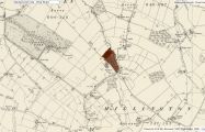
Robin Hood Hay and Little Robin Hood Hay indicated in, respectively, brown and maroon / Detail of 6" O.S. map Cheshire XVII.SE (1899; rev. 1897) (georeferenced); reprod. with perm. of NLS; under Creative Commons Attrib. (CC-BY) license; adapt. Henrik Thiil Nielsen.
