
Robin Hood Gate (Richmond Park): Difference between revisions
m (Text replacement - "=== Maps ===" to "== Maps ==") |
mNo edit summary |
||
| (28 intermediate revisions by the same user not shown) | |||
| Line 1: | Line 1: | ||
__NOTOC__{{ | __NOTOC__{{PlaceNamesItemTop|Lat=51.436358|Lon=-0.256332|AdministrativeDivision=Surrey|Vicinity=Leading into Richmond Park from the A308|Type=Thoroughfare|Interest=Robin Hood name| | ||
Status=Extant|Demonym=English|Riding=|GreaterLondon=Yes|Year=1873|Aka=|Century=19|Cluster1=Kingston Vale|Cluster2=|Cluster3=|Image= | Status=Extant|Demonym=English|Riding=|GreaterLondon=Yes|Year=1873|Aka=|Century=19|Cluster1=Kingston Vale|Cluster2=|Cluster3=|Image=geograph-5283506-by-John-Slater.jpg|Postcards=|ExtraCat1=|ExtraCat2=|ExtraCat3=|ExtraCat4=|ExtraCat5=|ExtraLink1=|ExtraLink2=|ExtraLink3=|ExtraLink4=|ExtraLink5=|ExtraLinkName1=|ExtraLinkName2=|ExtraLinkName3=|ExtraLinkName4=|ExtraLinkName5=|GeopointPrefix=|GeopointSuffix=|VicinitySuffix=|StatusSuffix=|DatePrefix=|DateSuffix=}} | ||
{{#display_map:{{#var:Coords}}~{{#replace:{{PAGENAME}}|'|'}}|width=34%}}<div class="pnMapLegend">{{PAGENAME}}.</div> | {{#display_map:{{#var:Coords}}~{{#replace:{{PAGENAME}}|'|'}}|width=34%|enablefullscreen=yes}}<div class="pnMapLegend">{{PAGENAME}}.</div> | ||
[[File:{{#var: | [[File:{{#var:Image}}|thumb|right|500px|Robin Hood Gate, Richmond Park / [https://www.geograph.org.uk/photo/5283506 John Slater, 14 Feb. 2017; Creative Commons, via Geograph.]]]<div class="no-img"> | ||
<p id="byline">By Henrik Thiil Nielsen, 2018-01-13. Revised by {{#realname:{{REVISIONUSER}}}}, {{REVISIONYEAR}}-{{REVISIONMONTH}}-{{REVISIONDAY2}}.</p | <p id="byline">By Henrik Thiil Nielsen, 2018-01-13. Revised by {{#realname:{{REVISIONUSER}}}}, {{REVISIONYEAR}}-{{REVISIONMONTH}}-{{REVISIONDAY2}}.</p> | ||
Robin Hood Gate into Richmond Park by the A308 has a long history, but the earliest reference | Robin Hood Gate into Richmond Park by the A308 has a long history, but the earliest reference known to IRHB as of this moment is a 6" O.S. map of the area published in 1873. | ||
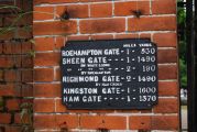
Access to Richmond Park through Robin Hood Gate is allowed for pedestrians, cyclists and horse riders, but motor vehicles are no longer allowed. A black plate on the left of the gate lists distances to the other gates in the park.<ref>[https://www.geograph.org.uk/photo/676184 Geograph: TQ2172 : Richmond Park: Robin Hood Gate]; [https://www.geograph.org.uk/photo/2575565 Geograph: TQ2172 : Sign at Robin Hood Gate, Richmond Park.]</ref>{{PlaceNamesItemAllusionsAndRecords}} | |||
== Gazetteers == | == Gazetteers == | ||
* | * {{:Dobson, Richard Barrie 1976a}}, p. 304. | ||
== Maps == | == Maps == | ||
* [http://maps.nls.uk/view/102345976#zoom=6&lat=908&lon=5084&layers=BT 6" O.S. map ''Middlesex'' XXI (1873; surveyed 1865-66)] | * [http://maps.nls.uk/view/102345976#zoom=6&lat=908&lon=5084&layers=BT 6" O.S. map ''Middlesex'' XXI (1873; surveyed 1865-66)] | ||
| Line 17: | Line 18: | ||
* [http://maps.nls.uk/view/101436457#zoom=5&lat=5916&lon=3709&layers=BT 6" O.S. map ''Surrey'' VII.SW (1936; rev. 1932-33)] | * [http://maps.nls.uk/view/101436457#zoom=5&lat=5916&lon=3709&layers=BT 6" O.S. map ''Surrey'' VII.SW (1936; rev. 1932-33)] | ||
* [http://maps.nls.uk/view/101725190#zoom=6&lat=6015&lon=3748&layers=BT 6" O.S. map ''Surrey'' VII.SW (''c.'' 1944; rev. 1938)] | * [http://maps.nls.uk/view/101725190#zoom=6&lat=6015&lon=3748&layers=BT 6" O.S. map ''Surrey'' VII.SW (''c.'' 1944; rev. 1938)] | ||
* [http://maps.nls.uk/view/101436454#zoom=6&lat=6007&lon=3684&layers=BT 6" O.S. map ''Surrey'' VII.SW (''c.'' 1946; rev. 1938) | * [http://maps.nls.uk/view/101436454#zoom=6&lat=6007&lon=3684&layers=BT 6" O.S. map ''Surrey'' VII.SW (''c.'' 1946; rev. 1938)] | ||
* [http://maps.nls.uk/view/96805044#zoom=6&lat=1312&lon=5201&layers=BT 6" O.S. map ''London'' X.SW (1894-96; rev. 1893-95)] | * [http://maps.nls.uk/view/96805044#zoom=6&lat=1312&lon=5201&layers=BT 6" O.S. map ''London'' X.SW (1894-96; rev. 1893-95)] | ||
* [https://maps.nls.uk/view/103313150#zoom=5&lat=1299&lon=4505&layers=BT 25" O.S. map ''London (1869; surveyed 1865-67)] | |||
* [https://maps.nls.uk/geo/explore/#zoom=19&lat=51.4365&lon=-0.2575&layers=168&b=5 25" O.S. map ''Surrey'' VII.9 (1897; rev. 1894)] (georeferenced) | |||
* [https://maps.nls.uk/geo/explore/#zoom=17&lat=51.4373&lon=-0.2582&layers=168&b=5 25" O.S. map ''London'' (1915- Numbered sheets) VIII.14 (1916; rev. 1913)] (georeferenced) | |||
* [https://maps.nls.uk/view/103313375#zoom=4&lat=1468&lon=3987&layers=BT 25" O.S. map ''London (1916; rev. 1913).] | |||
== Brief mention == | |||
* {{:Anderson, Alan B 1942a}}; see p. 57: notes in discussion of 'mounting blocks or upping stones for horsemen' that 'I believe there is, or was, at least one specimen combining milestone with mounting-block, but am uncertain where, though I rather think it was a rhymed milestone that stood on the old Portsmouth Road near the Robin Hood entrance to Richmond Park at Kingston Yale'. | |||
== Background == | |||
* [http://en.wikipedia.org/wiki/Richmond_Park Richmond Park.] | |||
== Notes == | |||
<references/> | |||
{{PlaceNamesItemAlsoSee}} | |||
</div> | |||
<div id="gallery"> | |||
{{ImageGalleryIntroduction}} | |||
<gallery widths="195px"> | |||
robin-hood-gate-kingston-vale-google-earth-street-view.jpg|Robin Hood Gate / Google Earth Street View. | |||
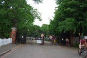
geograph-676184-by-Nigel-Cox.jpg|Robin Hood Gate / [https://www.geograph.org.uk/photo/676184 Nigel Cox, 30 Jan. 2008; Creative Commons, via Geograph.] | |||
geograph-2575565-by-N-Chadwick.jpg|Sign at Robin Hood Gate, Richmond Park / [https://www.geograph.org.uk/photo/2575565 N. Chadwick, 7 May 2011; Creative Commons, via Geograph.] | |||
geograph-2575561-by-N-Chadwick.jpg|Robin Hood Gate, Richmond Park / [https://www.geograph.org.uk/photo/2575561 N. Chadwick, 7 May 2011; Creative Commons, via Geograph.] | |||
geograph-3811706-by-Robin-Webster.jpg|Richmond Park from Robin Hood Gate / [https://www.geograph.org.uk/photo/3811706 Robin Webster, 22 Apr. 2012; Creative Commons, via Geograph.] | |||
geograph-4535742-by-David-Howard.jpg|The old road entrance to Robin Hood Gate / [https://www.geograph.org.uk/photo/4535742 David Howard, 22 Jun. 2015; Creative Commons, via Geograph.] | |||
geograph-2347278-by-Jim-Osley.jpg|Edwardian gates, Robin Hood Gate, Richmond Park / [https://www.geograph.org.uk/photo/2347278 Jim Osley, 7 Apr. 2011; Creative Commons, via Geograph.] | |||
geograph-1453983-by-Derek-Harper.jpg|Near Robin Hood Gate / [https://www.geograph.org.uk/photo/1453983 Derek Harper, 1 Aug. 2009; Creative Commons, via Geograph.] | |||
geograph-1273818-by-Stephen-Craven.jpg|Cycling through Robin Hood Gate / [https://www.geograph.org.uk/photo/1273818 Stephen Craven, 26 Apr. 2009; Creative Commons, via Geograph.] | |||
geograph-5283506-by-John-Slater.jpg|Robin Hood Gate, Richmond Park / [https://www.geograph.org.uk/photo/5283506 John Slater, 14 Feb. 2017; Creative Commons, via Geograph.] | |||
geograph-3524852-by-Dr-Neil-Clifton.jpg|Richmond Park: Robin Hood Gate / [https://www.geograph.org.uk/photo/3524852 Dr Neil CLifton, 23 Jun. 2013; Creative Commons, via Geograph.] | |||
</gallery> | |||
{{ | {{PlaceNamesItemNavigation}} | ||
Latest revision as of 14:58, 24 April 2022
| Locality | |
|---|---|
| Coordinate | 51.436358, -0.256332 |
| Adm. div. | Surrey, now Greater London |
| Vicinity | Leading into Richmond Park from the A308 |
| Type | Thoroughfare |
| Interest | Robin Hood name |
| Status | Extant |
| First Record | 1873 |

By Henrik Thiil Nielsen, 2018-01-13. Revised by Henrik Thiil Nielsen, 2022-04-24.
Robin Hood Gate into Richmond Park by the A308 has a long history, but the earliest reference known to IRHB as of this moment is a 6" O.S. map of the area published in 1873.
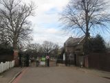
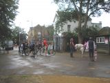
Access to Richmond Park through Robin Hood Gate is allowed for pedestrians, cyclists and horse riders, but motor vehicles are no longer allowed. A black plate on the left of the gate lists distances to the other gates in the park.[1]
Gazetteers
Maps
- 6" O.S. map Middlesex XXI (1873; surveyed 1865-66)
- 6" O.S. map Surrey VII (1874; surveyed 1865)
- 6" O.S. map Surrey VII.SW (1899; rev. 1893-95) (georeferenced)
- 6" O.S. map Surrey VII.SW (1899; rev. 1893-95)
- 6" O.S. map Surrey VII.SW (1920; rev. 1911)
- 6" O.S. map Surrey VII.SW (c. 1933; rev. 1911)
- 6" O.S. map Surrey VII.SW (1936; rev. 1932-33)
- 6" O.S. map Surrey VII.SW (c. 1944; rev. 1938)
- 6" O.S. map Surrey VII.SW (c. 1946; rev. 1938)
- 6" O.S. map London X.SW (1894-96; rev. 1893-95)
- 25" O.S. map London (1869; surveyed 1865-67)
- 25" O.S. map Surrey VII.9 (1897; rev. 1894) (georeferenced)
- 25" O.S. map London (1915- Numbered sheets) VIII.14 (1916; rev. 1913) (georeferenced)
- 25" O.S. map London (1916; rev. 1913).
Brief mention
- Anderson, Alan B. 'Records of the Turnpike Trust', Notes & Queries, vol. CLXXXIII (1942), pp. 56-57; see p. 57: notes in discussion of 'mounting blocks or upping stones for horsemen' that 'I believe there is, or was, at least one specimen combining milestone with mounting-block, but am uncertain where, though I rather think it was a rhymed milestone that stood on the old Portsmouth Road near the Robin Hood entrance to Richmond Park at Kingston Yale'.
Background
Notes
Also see
Image gallery
Click any image to display it in the lightbox, where you can navigate between images by clicking in the right or left side of the current image.
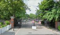
Robin Hood Gate / Google Earth Street View.

Robin Hood Gate / Nigel Cox, 30 Jan. 2008; Creative Commons, via Geograph.
Sign at Robin Hood Gate, Richmond Park / N. Chadwick, 7 May 2011; Creative Commons, via Geograph.
Robin Hood Gate, Richmond Park / N. Chadwick, 7 May 2011; Creative Commons, via Geograph.
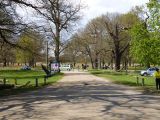
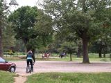
Richmond Park from Robin Hood Gate / Robin Webster, 22 Apr. 2012; Creative Commons, via Geograph.
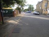
The old road entrance to Robin Hood Gate / David Howard, 22 Jun. 2015; Creative Commons, via Geograph.

Edwardian gates, Robin Hood Gate, Richmond Park / Jim Osley, 7 Apr. 2011; Creative Commons, via Geograph.
Near Robin Hood Gate / Derek Harper, 1 Aug. 2009; Creative Commons, via Geograph.

Cycling through Robin Hood Gate / Stephen Craven, 26 Apr. 2009; Creative Commons, via Geograph.
Robin Hood Gate, Richmond Park / John Slater, 14 Feb. 2017; Creative Commons, via Geograph.
Richmond Park: Robin Hood Gate / Dr Neil CLifton, 23 Jun. 2013; Creative Commons, via Geograph.


