
Robin Hood Court (Tooley Street)
From International Robin Hood Bibliography
Robin Hood Court (Tooley Street).
[[File:|thumb|right|500px|English Grounds, just north of Tooley Street, is the site of Robin Hood Court / Google Earth Street View.]]

John Rocque's 1746 map of London and Westminster centred on "Robin Woods C[ourt]" / Locating London's Past.

Richard Horwood's Plan of London (1792-99) centred on "Robin Hood Co[urt]" / Romantic London.
By Henrik Thiil Nielsen, 2018-06-24. Revised by Henrik Thiil Nielsen, 2018-06-24.
A Robin Hood Court once existed at what is now English Grounds on the east side of Battle Bridge Lane on the Thames side of Tooley Street. It is first recorded on John Rocque's map of London and Westminster (1746).
Gazetteers
- Not included in Dobson, R. B., ed.; Taylor, J., ed. Rymes of Robyn Hood: an Introduction to the English Outlaw (London, 1976), pp. 293-311.
Maps
- 25" O.S. map London (First Editions c1850s) XLV (1878; surveyed 1872)
- 25" O.S. map London (Edition of 1894-96) LXXVII (1897; rev. 1893-94)
- 25" O.S. map London (1915- Numbered sheets) V.15 (1934; rev. 1914)
- 25" O.S. map London (Edition of 1894-96) LXXVII (1897; rev. 1893-94) (georeferenced)]
- 6" O.S. map Middlesex XVII (1880-82; surveyed 1868-73)
- 6" O.S. map Surrey III (1880; surveyed 1868-73)
- 6" O.S. map London VII.SE (1894-96; rev. 1893-94)
- 6" O.S. map Surrey III.NW (1898; rev. 1893-95)
- 6" O.S. map Surrey III.NW (1898; rev. 1893-95) (georeferenced)
- 6" O.S. map London Sheet K (1920; rev. 1913-14)
- 6" O.S. map London Sheet K (c. 1946; rev. 1938).
Notes

English Grounds, just north of Tooley Street, is the site of Robin Hood Court / Google Earth Street View.
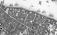
John Rocque's 1746 map of London and Westminster centred on "Robin Woods C[ourt]" / Locating London's Past.
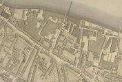
Richard Horwood's Plan of London (1792-99) centred on "Robin Hood Co[urt]" / Romantic London.
