
Robin Hood Court (St Giles): Difference between revisions
mNo edit summary |
mNo edit summary |
||
| Line 1: | Line 1: | ||
__NOTOC__{{PnItemTop|Lat=51.516304|Lon=-0.127550|AdmDiv=Middlesex|Vicinity=Church Lane, St Giles; Slightly W of Dyott Street and S of Bucknall Street; between New Oxford Street and Shaftesbury Avenue|Type=Area|Interest=Robin Hood name| | __NOTOC__{{PnItemTop|Lat=51.516304|Lon=-0.127550|AdmDiv=Middlesex|Vicinity=Church Lane, St Giles; Slightly W of Dyott Street and S of Bucknall Street; between New Oxford Street and Shaftesbury Avenue|Type=Area|Interest=Robin Hood name| | ||
Status=Defunct|Demonym=|Riding=|GreaterLondon=Yes|Year=1810|Aka=|Century=|Cluster1=St Giles|Cluster2=|Cluster3=|Image=robin-hood-court-st-giles-google-earth-street-view.jpg|Postcards=|ExtraCat1=|ExtraCat2=|ExtraCat3=|ExtraCat4=|ExtraCat5=|ExtraLink1=|ExtraLink2=|ExtraLink3=|ExtraLink4=|ExtraLink5=|ExtraLinkName1=|ExtraLinkName2=|ExtraLinkName3=|ExtraLinkName4=|Extraordinaire=|GeopointPrefix=|GeopointSuffix=|VicinitySuffix=|StatusSuffix=|DatePrefix=|DateSuffix=}} | Status=Defunct|Demonym=|Riding=|GreaterLondon=Yes|Year=1810|Aka=|Century=|Cluster1=St Giles|Cluster2=|Cluster3=|Image=robin-hood-court-st-giles-google-earth-street-view.jpg|Postcards=|ExtraCat1=|ExtraCat2=|ExtraCat3=|ExtraCat4=|ExtraCat5=|ExtraLink1=|ExtraLink2=|ExtraLink3=|ExtraLink4=|ExtraLink5=|ExtraLinkName1=|ExtraLinkName2=|ExtraLinkName3=|ExtraLinkName4=|Extraordinaire=|GeopointPrefix=|GeopointSuffix=|VicinitySuffix=|StatusSuffix=|DatePrefix=|DateSuffix=}} | ||
{{#display_map:{{#var:Coords}}~{{#replace:{{PAGENAME}}|'|'}}|width=34%}}<div class="pnMapLegend">Robin | {{#display_map:{{#var:Coords}}~{{#replace:{{PAGENAME}}|'|'}}|width=34%}}<div class="pnMapLegend">Robin Hood Court was somewhere near the point indicated.</div> | ||
[[File:{{#var:Pnimage}}|thumb|right|500px|Robin Hood Court was quite close to this spot, perhaps a little south of it / Google Earth Street View.]] | [[File:{{#var:Pnimage}}|thumb|right|500px|Robin Hood Court was quite close to this spot, perhaps a little south of it / Google Earth Street View.]] | ||
<p id="byline">By Henrik Thiil Nielsen, 2018-06-23. Revised by {{#realname:{{REVISIONUSER}}}}, {{REVISIONYEAR}}-{{REVISIONMONTH}}-{{REVISIONDAY2}}.</p><div class="no-img"> | <p id="byline">By Henrik Thiil Nielsen, 2018-06-23. Revised by {{#realname:{{REVISIONUSER}}}}, {{REVISIONYEAR}}-{{REVISIONMONTH}}-{{REVISIONDAY2}}.</p><div class="no-img"> | ||
| Line 31: | Line 31: | ||
{{ImgGalleryIntro}} | {{ImgGalleryIntro}} | ||
<gallery widths="195px"> | <gallery widths="195px"> | ||
File:robin-hood-court-st-giles-google-earth-street-view.jpg|Robin Hood Court was quite close to this spot, perhaps a little south of it / Google Earth Street View. | File:robin-hood-court-st-giles-google-earth-street-view.jpg|Robin Hood Court was quite close to this spot, perhaps a little south of it / Google Earth Street | ||
View. | |||
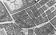
File:robin-hood-court-st-giles-john-rocque-1746-locating-londons-past.jpg||Church Street and Lane on John Rocque's 1746 map of London. By the time Lockie compiled his ''Topography'' they had exchanged names. | |||
</gallery> | </gallery> | ||
{{PnItemNav}} | {{PnItemNav}} | ||
Revision as of 12:54, 23 June 2018
[[File:|thumb|right|500px|Robin Hood Court was quite close to this spot, perhaps a little south of it / Google Earth Street View.]]
By Henrik Thiil Nielsen, 2018-06-23. Revised by Henrik Thiil Nielsen, 2018-06-23.
Robin Hood Court was a small cul-de-sac not far from the southern end of Bucknall Street and thus near Dyott Street. It is known only from early 19th century topographical reference works.
John Lockie in his Topography of London (1810) lists the court as "Robinhood-Court, Church-Lane, St. Giles's,—about four doors on the L. from Diot-street, near Phænix-street".[1] In the 1813 edition this has become: "Robinhood Court, Church Lane,—4 doors from George-st. Bloomsbury".[2] It is also included in James Elmes's Topographical Dictionary of London (1831).[3]
Gazetteers
- Not included in Dobson, R. B., ed.; Taylor, J., ed. Rymes of Robyn Hood: an Introduction to the English Outlaw (London, 1976), pp. 293-311.
Sources
- Elmes, James, compil. A Topographical Dictionary of London and Its Environs (London, 1831), s.n. Robinhood-Ct.
- Lockie, John, compil. Lockie's Topography of London, Giving a Concise Local Description of and Accurate Direction to Every Square, Street, Lane, Court, Dock, Wharf, Inn, Public Office, &c. in the Metropolis and its Environs (London, 1810), s.n. Robinhood-Court [I]
- Lockie, John, compil. Lockie's Topography of London, Giving a Concise Local Description of, and Accurate Direction to, Every Square, Street, Lane, Court, Dock, Wharf, Inn, Public Office, &c. in the Metropolis and its Environs. Second Edition (London, 1813), s.n. Robinhood Court [I].
Background
Notes
- ↑ Lockie, John, compil. Lockie's Topography of London, Giving a Concise Local Description of and Accurate Direction to Every Square, Street, Lane, Court, Dock, Wharf, Inn, Public Office, &c. in the Metropolis and its Environs (London, 1810), s.n. Robinhood-Court [I].
- ↑ Lockie, John, compil. Lockie's Topography of London, Giving a Concise Local Description of, and Accurate Direction to, Every Square, Street, Lane, Court, Dock, Wharf, Inn, Public Office, &c. in the Metropolis and its Environs. Second Edition (London, 1813), s.n. Robinhood Court [I].
- ↑ Elmes, James, compil. A Topographical Dictionary of London and Its Environs (London, 1831), s.n. Robinhood-Ct.

Robin Hood Court was quite close to this spot, perhaps a little south of it / Google Earth Street
- View.
Church Street and Lane on John Rocque's 1746 map of London. By the time Lockie compiled his Topography they had exchanged names.

