Robin Hood Court (St Clement Danes): Difference between revisions
mNo edit summary |
mNo edit summary |
||
| Line 3: | Line 3: | ||
{{#display_map:{{#var:Coords}}~{{#replace:{{PAGENAME}}|'|'}}|width=34%}}<div class="pnMapLegend">{{PAGENAME}}.</div> | {{#display_map:{{#var:Coords}}~{{#replace:{{PAGENAME}}|'|'}}|width=34%}}<div class="pnMapLegend">{{PAGENAME}}.</div> | ||
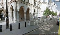
[[File:{{#var:Pnimage}}|thumb|right|500px|The Robin Hood Court was probably located somewhere within the area now occupied by the Royal Courts of Justice / Google Earth Street View.]] | [[File:{{#var:Pnimage}}|thumb|right|500px|The Robin Hood Court was probably located somewhere within the area now occupied by the Royal Courts of Justice / Google Earth Street View.]] | ||
[[File:robin-hood-court-st-clements-danes-richard-horwood-romantic london.jpg|thumb|right|500px|Robin Hood Court was probably the area indicated by the red arrow / Richard Horwood's ''Plan of the Cities of London and Westminster'' (1792-99) at [http://www.romanticlondon.org/maps/fullscreen/layer/17/#18/51.51357/-0.11388 Romantic London.]]] | [[File:robin-hood-court-st-clements-danes-richard-horwood-romantic london.jpg|thumb|right|500px|Robin Hood Court was probably the area indicated by the red arrow / Adapted from Richard Horwood's ''Plan of the Cities of London and Westminster'' (1792-99) at [http://www.romanticlondon.org/maps/fullscreen/layer/17/#18/51.51357/-0.11388 Romantic London.]]] | ||
<p id="byline">By Henrik Thiil Nielsen, 2018-06-23. Revised by {{#realname:{{REVISIONUSER}}}}, {{REVISIONYEAR}}-{{REVISIONMONTH}}-{{REVISIONDAY2}}.</p><div class="no-img"> | <p id="byline">By Henrik Thiil Nielsen, 2018-06-23. Revised by {{#realname:{{REVISIONUSER}}}}, {{REVISIONYEAR}}-{{REVISIONMONTH}}-{{REVISIONDAY2}}.</p><div class="no-img"> | ||
Robin Hood Court was located a little north-east of the church of St Clement Danes in an area now occupied by the Royal Courts of Justice. It is noted in early 19th century topographical references works on London. | Robin Hood Court was located a little north-east of the church of St Clement Danes in an area now occupied by the Royal Courts of Justice. It is noted in early 19th century topographical references works on London. | ||
| Line 37: | Line 37: | ||
<gallery widths="195px"> | <gallery widths="195px"> | ||
File:robin-hood-court-st-clement-danes-google-earth-street-view.jpg|thumb|right|500px|The Robin Hood Court was probably located somewhere within the area now occupied by the Royal Courts of Justice / Google Earth Street View. | File:robin-hood-court-st-clement-danes-google-earth-street-view.jpg|thumb|right|500px|The Robin Hood Court was probably located somewhere within the area now occupied by the Royal Courts of Justice / Google Earth Street View. | ||
File:robin-hood-court-st-clements-danes-richard-horwood-romantic london.jpg|thumb|right|500px|Robin Hood Court was probably the area indicated by the red arrow / Richard Horwood's ''Plan of the Cities of London and Westminster'' (1792-99) at [http://www.romanticlondon.org/maps/fullscreen/layer/17/#18/51.51357/-0.11388 Romantic London.] | File:robin-hood-court-st-clements-danes-richard-horwood-romantic london.jpg|thumb|right|500px|Robin Hood Court was probably the area indicated by the red arrow / Adapted from Richard Horwood's ''Plan of the Cities of London and Westminster'' (1792-99) at [http://www.romanticlondon.org/maps/fullscreen/layer/17/#18/51.51357/-0.11388 Romantic London.] | ||
</gallery> | </gallery> | ||
{{PnItemNav}} | {{PnItemNav}} | ||
Revision as of 16:46, 23 June 2018
[[File:|thumb|right|500px|The Robin Hood Court was probably located somewhere within the area now occupied by the Royal Courts of Justice / Google Earth Street View.]]
By Henrik Thiil Nielsen, 2018-06-23. Revised by Henrik Thiil Nielsen, 2018-06-23.
Robin Hood Court was located a little north-east of the church of St Clement Danes in an area now occupied by the Royal Courts of Justice. It is noted in early 19th century topographical references works on London.
Lockie in his Topography of London (editions of 1810 and 1813) notes a ""Robinhood-Court, Newcastle-Court, Strand,—the first on the L., a few yards from Picket-st. or the Strand, near Temple-bar" (see gazetteers below). "Picket Street" was then the name of the Strand on the north side of the church of St Clement Danes.[1]
Gazetteers
- Not included in Dobson, R. B., ed.; Taylor, J., ed. Rymes of Robyn Hood: an Introduction to the English Outlaw (London, 1976), pp. 293-311
- Elmes, James, compil. A Topographical Dictionary of London and Its Environs (London, 1831), p. 354, s.n. Robinhood-Ct.
- Lockie, John, compil. Lockie's Topography of London, Giving a Concise Local Description of and Accurate Direction to Every Square, Street, Lane, Court, Dock, Wharf, Inn, Public Office, &c. in the Metropolis and its Environs (London, 1810), s.n. Robinhood-Court [2]
Maps
Background
Notes
- Robin-hood-court-st-clements-danes-richard-horwood-romantic london.jpg
Robin Hood Court was probably the area indicated by the red arrow / Adapted from Richard Horwood's Plan of the Cities of London and Westminster (1792-99) at Romantic London.

