Robin Hood Cottage (Whatstandwell): Difference between revisions
From International Robin Hood Bibliography
mNo edit summary |
mNo edit summary |
||
| Line 49: | Line 49: | ||
{{#set:century=19th}} | {{#set:century=19th}} | ||
{{#set:Utitle={{#replace:{{uc:{{PAGENAME}}}}|'|'}}}} | {{#set:Utitle={{#replace:{{uc:{{PAGENAME}}}}|'|'}}}} | ||
{{#set:Pnimage=robin-hood-cottage-whatstandwell-google-earth.jpg}} | |||
{{#set:Pnimage=robin-hood-cottage-whatstandwell-google-earth.jpg}} | {{#set:Pnimage=robin-hood-cottage-whatstandwell-google-earth.jpg}} | ||
Revision as of 18:18, 9 June 2017
| Locality | |
|---|---|
| Coordinates | 53.0919, -1.5051 |
| Adm. div. | Derbyshire |
| Vicinity | c. 6 km SE of Matlock |
| Type | Building |
| Interest | Robin Hood name |
| Status | Extant |
| First Record | 1884 |
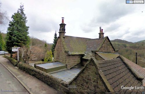
Robin Hood Cottage.
By Henrik Thiil Nielsen, 2016-12-30. Revised by Henrik Thiil Nielsen, 2017-06-09.
Robin Hood Cottage is located in the hamlet of Robin Hood on Leashaw Road in Whatstandwell, Derbyshire. The earliest record I have found of the cottage is a 6" O.S. map of the area published in 1884 (see Maps section below).
Gazetteers
- Not included in Dobson, R. B., ed.; Taylor, J., ed. Rymes of Robyn Hood: an Introduction to the English Outlaw (London, 1976), pp. 293-311.
Maps
- 6" O.S. map Derbyshire XXXIV.SE (1884; surveyed 1879)
- 6" O.S. map Derbyshire XXXIV.SE (1900; rev. 1898) (georeferenced)
- 6" O.S. map Derbyshire XXXIV (1924; rev. 1920)
- 6" O.S. map Derbyshire XXXIV (c. 1949; rev. 1938).
Also see
"th" can not be assigned to a declared number type with value 19.

