
Robin Hood Cottage (Mawdesley)
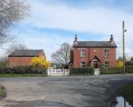
[[File:|thumb|right|500px|Robin Hood Cottage / Gary Rogers, 13 Apr. 2016, Creative Commons, via Geograph.]]
By Henrik Thiil Nielsen, 2013-08-07. Revised by Henrik Thiil Nielsen, 2019-02-15.
Robin Hood Cottage on Blue Stone Lane in Mawdesley is located at the junction of Bluestone, Tannersmith, Tincklers and Sydbrook lanes. Its history goes back to 1841 if not earlier.
According to a recent advert, the history of the pub goes back to the 15th century, but Richard Langford, a local researcher, has found no evidence to support this claim. The earliest landlord we know about is a Hugh Swift in 1841. There is no record of the inn's name at the time,[1] but the pub is included as "Robin Hood" on the 6" O.S. map of the area published in 1847, based on a survey carried out 1845-46 (see Maps below).
According to Richard Langford, Tincklers Lane was previously named Robin Hood Lane.[2]
Source
Maps
- 25" O.S. map Lancashire LXXVI.12 (c. 1894; rev. c. 1892-93).] No Copy in NLS
- 25" O.S. map Lancashire LXXVI.12 (1910; rev. 1908) (georeferenced)
- 25" O.S. map Lancashire LXXVI.12 (1910; rev. 1908)
- 25" O.S. map Lancashire LXXVI.12 (1928; rev. 1926)
- 6" O.S. map Lancashire LXXVI (1847; surveyed 1845-46)
- 6" O.S. map Lancashire LXXVI.SE (1894; surveyed 1891-93)
- 6" O.S. map Lancashire LXXVI.SE (1911; rev. 1908) (georeferenced)
- 6" O.S. map Lancashire LXXVI.SE (1911; rev. 1908)
- 6" O.S. map Lancashire LXXVI.SE (1929; rev. 1926).
Notes
Robin Hood Cottage / Gary Rogers, 13 Apr. 2016, Creative Commons, via Geograph.

Robin Hood Cottage / Google Earth Street View.

