
Robin Hood Community Garden (Upper Clapton): Difference between revisions
From International Robin Hood Bibliography
m (Text replacement - "|service=leaflet}}" to "|service=leaflet|enablefullscreen=yes}}") |
rh>Henryfunk mNo edit summary |
||
| Line 21: | Line 21: | ||
== Notes == | == Notes == | ||
<references/> | <references/> | ||
</div> | </div> | ||
<div id="gallery"> | |||
{{ImgGalleryIntro}} | {{ImgGalleryIntro}} | ||
<gallery widths="195px"> | <gallery widths="195px"> | ||
| Line 30: | Line 29: | ||
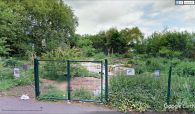
File:robin-hood-tavern-upper-clapton-google-maps-street-view.jpg|Robin Hood Community Garden / Google Maps Street View. | File:robin-hood-tavern-upper-clapton-google-maps-street-view.jpg|Robin Hood Community Garden / Google Maps Street View. | ||
</gallery> | </gallery> | ||
</div> | |||
{{PnItemNav}} | {{PnItemNav}} | ||
Revision as of 00:07, 15 May 2020
Robin Hood Community Garden (Upper Clapton).
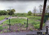
[[File:|thumb|right|500px|Robin Hood Community Garden / Google Earth Street View.]]
By Henrik Thiil Nielsen, 2018-02-15. Revised by 18.118.45.162, 2020-05-15.
An empty lot a few meters north of the site of the Robin Hood Tavern at High Hill Ferry has been turned into Robin Hood Community Garden. Work on this community project started in March of 2010. The sign of the demolished pub was found among the weeds in the empty lot and has now been given a new home in the community garden.[1]Template:PnItemQry
Gazetteers
- Not included in Dobson, R. B., ed.; Taylor, J., ed. Rymes of Robyn Hood: an Introduction to the English Outlaw (London, 1976), pp. 293-311.
Sources
Background
Notes
Robin Hood Community Garden / Google Earth Street View.
Robin Hood Community Garden / Google Maps Street View.

