|
|
| Line 1: |
Line 1: |
| __NOTOC__ | | __NOTOC__{{PnItemTop|Lat=52.576221|Lon=-0.296035|AdmDiv=Northamptonshire|Vicinity=In Bretton, off Bretton Way|Type=Thoroughfare|Interest=Robin Hood name|Status=Extant|Demonym=|Riding=|GreaterLondon=|Year=|Aka=|Century=|Cluster1=Bretton|Cluster2=|Image=Rh close peterborough google earth.jpg|Postcards=|ExtraCat1=Places named Robin Hood's Close.|ExtraCat2=|ExtraCat3=|ExtraCat4=|ExtraCat5=|GeopointPrefix=|GeopointSuffix=|VicinitySuffix=|StatusSuffix=|DatePrefix=|DateSuffix=?}} |
| {{Infobox | | {{#display_map:{{#var:Coords}}|width=34%}}<div class="pnMapLegend">Approximate location of Robin Hood Close Close</div> |
| |header1=Locality
| |
| |label2=Coordinates
| |
| |data2=[[Geopoint::52.576221,-0.296035]]
| |
| |label3=Adm. div.
| |
| |data3=[[pnadmdiv::Northamptonshire]]
| |
| |label4=Vicinity
| |
| |data4 = [[pnvicinity::In Bretton, off Bretton Way]]
| |
| |label5 = Type
| |
| |data5=[[pntype::Thoroughfare]]
| |
| |label6=Interest
| |
| |data6=[[pninterest::Robin Hood name]]
| |
| |label7=Status
| |
| |data7=[[pnstatus::Extant]]
| |
| |label8=First Record
| |
| |data8=[[pnfirstrecord::]]?
| |
| }} | |
| {{#display_map:52.576221,-0.296035|width=34%}}<div class="pnMapLegend">Approximate location of Robin Hood Close Close</div> | |
| [[File:Rh close peterborough google earth.jpg|thumb|right|500px|Robin Hood Close Close, Bretton, Peterborough (photo: Google Earth).]] | | [[File:Rh close peterborough google earth.jpg|thumb|right|500px|Robin Hood Close Close, Bretton, Peterborough (photo: Google Earth).]] |
| <p id="byline">By Henrik Thiil Nielsen, 2014-10-18. Revised by {{#realname:{{REVISIONUSER}}}}, {{REVISIONYEAR}}-{{REVISIONMONTH}}-{{REVISIONDAY2}}.</p><div class="no-img"> | | <p id="byline">By Henrik Thiil Nielsen, 2014-10-18. Revised by {{#realname:{{REVISIONUSER}}}}, {{REVISIONYEAR}}-{{REVISIONMONTH}}-{{REVISIONDAY2}}.</p><div class="no-img"> |
| Line 30: |
Line 13: |
|
| |
|
|
| |
|
| </div> | | </div><!-- |
| <div id="dplcatlinks" class="subcategory"><div id="dplcatarea"> | | {{ImgGalleryIntro}} |
| {{#ask: [[Category:English place-names]]
| | <gallery widths="195px"> |
| [[Category:Northamptonshire place-names]][[Utitle::<<{{#replace:{{uc:{{PAGENAME}}}}|'|'}}]]|order=descending|searchlabel=|format=template|introtemplate=BeforeNav|template=Nav|outrotemplate=Previous|link=none|limit=1|sort=Utitle}}[[Northamptonshire place-names]]{{#ask: [[Category:English place-names]]
| | FOR EACH IMAGE: File:_FILENAME.jpg|_LEGEND / [_URL _PHOTOGRAPHER, _DAY _MON. _YEAR, Creative Commons.] |
| [[Category:Northamptonshire place-names]][[Utitle::>>{{#replace:{{uc:{{PAGENAME}}}}|'|'}}]]|order=ascending|searchlabel=|format=template|introtemplate=BeforeNav|template=Nav|outrotemplate=Next|link=none|limit=1|sort=Utitle}}<br/>
| | </gallery>--> |
| {{#ask: [[Category:English place-names]][[Utitle::<<{{#replace:{{uc:{{PAGENAME}}}}|'|'}}]]|order=descending|searchlabel=|format=template|introtemplate=BeforeNav|template=Nav|outrotemplate=Previous|link=none|limit=1|sort=Utitle}}[[Place-names]]{{#ask: [[Category:English place-names]][[Utitle::>>{{#replace:{{uc:{{PAGENAME}}}}|'|'}}]]|order=ascending|searchlabel=|format=template|introtemplate=BeforeNav|template=Nav|outrotemplate=Next|link=none|limit=1|sort=Utitle}}</div></div>
| | |
| [[Category:Place-names-topics]]
| | {{PnItemNav}} |
| [[Category:English place-names]]
| |
| [[Category:Northamptonshire place-names]]
| |
| [[Category:Bretton place-name cluster]]
| |
| [[Category:Places named Robin Hood's Close]].
| |
| [[Category:unknown century]]
| |
| {{#set:century=?}}
| |
| {{#set:Utitle={{#replace:{{uc:{{PAGENAME}}}}|'|'}}}}
| |
| {{#set:Pnimage=Rh close peterborough google earth.jpg}} | |
Template:PnItemTop
Loading map...
{"minzoom":false,"maxzoom":false,"mappingservice":"leaflet","width":"34%","height":"400px","centre":false,"title":"","label":"","icon":"","lines":[],"polygons":[],"circles":[],"rectangles":[],"copycoords":false,"static":false,"zoom":false,"defzoom":9,"layers":["OpenStreetMap","NLS","Stamen.Terrain"],"image layers":[],"overlays":[],"resizable":false,"fullscreen":false,"scrollwheelzoom":true,"cluster":false,"clustermaxzoom":20,"clusterzoomonclick":true,"clustermaxradius":80,"clusterspiderfy":true,"geojson":"","clicktarget":"","imageLayers":[],"locations":[],"imageoverlays":null}
Approximate location of Robin Hood Close Close
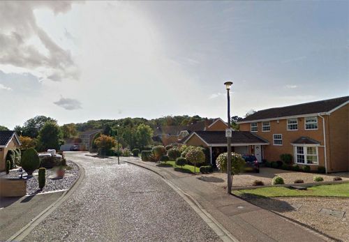
Robin Hood Close Close, Bretton, Peterborough (photo: Google Earth).
By Henrik Thiil Nielsen, 2014-10-18. Revised by Henrik Thiil Nielsen, 2017-12-05.
A small street in a residential area in Bretton, Peterborough. There is a Little John's Close (not Little John Close) in the neighbourhood.
Gazetteers
- Not included in Dobson, R. B., ed.; Taylor, J., ed. Rymes of Robyn Hood: an Introduction to the English Outlaw (London, 1976), pp. 293-311
- Not included in Gover, J.E.B.; Mawer, A.; Stenton, F.M. The Place-Names of Northamptonshire (English Place-Name Society, vol. X) (Cambridge, 1933).
Also see
Template:PnItemNav

