
Robin Hood Close (Giggleswick): Difference between revisions
m (Text replacement - "=== Printed sources ===" to "== Printed sources ==") |
m (Text replacement - "embedformat=h4" to "embedformat=h3") |
||
| Line 7: | Line 7: | ||
'Robin Hood's Close' was or is the name of a pasture located between the Ribble to the east and Stainforth Lane to the west, ''c.'' 1 km NNE of Stackhouse, a vicnity formerly part of the West Riding of Yorkshire but now administratively belonging to North York­shire. The locality is listed in an 1843-45 tithe award as 'Robin Hood Close', its owner a Rosetta Anne Carr, its occupier a Robert Atkinson, its state of cultivation pasture, and its area 5 acres and 39 perches ({{AcreRoodPerchToM2|5|0|39}} m<sup>2</sup>).<ref>{{:Smith, Albert Hugh 1961a}}, vol. VI, p. 146. Plot No. 338 in MS tithe award: [https://www.thegenealogist.com/image_viewer/?imagego=5QIH2T2WPVLBR_rz7g5lyEcKvVpX0gSQ9AVPicWgEFeeIZEfYAn_jEkWSn6u0ghP6BQZvptx2fnVZ0OLD5FNpN8ITY7MtewB9FPTC0onZTeR_SOqsfsTFa7Y41syC2id&id=57735556&r%5B1%5D=43&r%5B2%5D=168&r%5B3%5D=002 The Genealogist: Piece 43, sub-piece 168, image 88]] (schedule) (Paid subscription required), [https://www.thegenealogist.com/image_viewer/?imagego=5QIH2T2WPVLBR_rz7g5lyEcKvVpX0gSQ9AVPicWgEFeeIZEfYAn_jEkWSn6u0ghP6BQZvptx2fnVZ0OLD5FNpN8ITY7MtewB9FPTC0onZTeR_SOqsfsTFa7Y41syC2id&id=57735556&r%5B1%5D=43&r%5B2%5D=168&r%5B3%5D=002 The Genealogist: Piece 43, sub-piece 168, sub-image 002] (map) (subscription required). Map drawn 1843, schedule drawn up 1844, official date of receipt 1845.</ref> The locality is included, as 'Robin Hood's Pasture', on the 1851 O.S. 6" map of the area, which also has [[Robin Hood's Mill (Stackhouse)|Robin Hood's Mill]] immediately north or northwest of it. However, the pasture/close is not indicated on the 6" O.S. maps of 1896 and 1910 (see Maps section below).<!-- | 'Robin Hood's Close' was or is the name of a pasture located between the Ribble to the east and Stainforth Lane to the west, ''c.'' 1 km NNE of Stackhouse, a vicnity formerly part of the West Riding of Yorkshire but now administratively belonging to North York­shire. The locality is listed in an 1843-45 tithe award as 'Robin Hood Close', its owner a Rosetta Anne Carr, its occupier a Robert Atkinson, its state of cultivation pasture, and its area 5 acres and 39 perches ({{AcreRoodPerchToM2|5|0|39}} m<sup>2</sup>).<ref>{{:Smith, Albert Hugh 1961a}}, vol. VI, p. 146. Plot No. 338 in MS tithe award: [https://www.thegenealogist.com/image_viewer/?imagego=5QIH2T2WPVLBR_rz7g5lyEcKvVpX0gSQ9AVPicWgEFeeIZEfYAn_jEkWSn6u0ghP6BQZvptx2fnVZ0OLD5FNpN8ITY7MtewB9FPTC0onZTeR_SOqsfsTFa7Y41syC2id&id=57735556&r%5B1%5D=43&r%5B2%5D=168&r%5B3%5D=002 The Genealogist: Piece 43, sub-piece 168, image 88]] (schedule) (Paid subscription required), [https://www.thegenealogist.com/image_viewer/?imagego=5QIH2T2WPVLBR_rz7g5lyEcKvVpX0gSQ9AVPicWgEFeeIZEfYAn_jEkWSn6u0ghP6BQZvptx2fnVZ0OLD5FNpN8ITY7MtewB9FPTC0onZTeR_SOqsfsTFa7Y41syC2id&id=57735556&r%5B1%5D=43&r%5B2%5D=168&r%5B3%5D=002 The Genealogist: Piece 43, sub-piece 168, sub-image 002] (map) (subscription required). Map drawn 1843, schedule drawn up 1844, official date of receipt 1845.</ref> The locality is included, as 'Robin Hood's Pasture', on the 1851 O.S. 6" map of the area, which also has [[Robin Hood's Mill (Stackhouse)|Robin Hood's Mill]] immediately north or northwest of it. However, the pasture/close is not indicated on the 6" O.S. maps of 1896 and 1910 (see Maps section below).<!-- | ||
{{#ask:[[Category:Allusions (Robin Hood Close in Giggleswick)]]|format=embedded|embedformat= | {{#ask:[[Category:Allusions (Robin Hood Close in Giggleswick)]]|format=embedded|embedformat=h3|columns=1|limit=1000|sort=Utitle}} | ||
--> | --> | ||
== Gazetteers == | == Gazetteers == | ||
Revision as of 15:44, 12 July 2018
.jpg)

By Henrik Thiil Nielsen, 2014-08-27. Revised by Henrik Thiil Nielsen, 2018-07-12.
'Robin Hood's Close' was or is the name of a pasture located between the Ribble to the east and Stainforth Lane to the west, c. 1 km NNE of Stackhouse, a vicnity formerly part of the West Riding of Yorkshire but now administratively belonging to North Yorkshire. The locality is listed in an 1843-45 tithe award as 'Robin Hood Close', its owner a Rosetta Anne Carr, its occupier a Robert Atkinson, its state of cultivation pasture, and its area 5 acres and 39 perches (Template:AcreRoodPerchToM2 m2).[1] The locality is included, as 'Robin Hood's Pasture', on the 1851 O.S. 6" map of the area, which also has Robin Hood's Mill immediately north or northwest of it. However, the pasture/close is not indicated on the 6" O.S. maps of 1896 and 1910 (see Maps section below).
Gazetteers
- Not included in Dobson, R. B., ed.; Taylor, J., ed. Rymes of Robyn Hood: an Introduction to the English Outlaw (London, 1976), pp. 293-311.
Maps
- 6" O.S. Map Sheet 132 (1851, surveyed 1847) (Robin Hood's Pasture indicated)
- 6" O.S. Map Yorkshire Sheet CXXXII (1896, surveyed 1893-94) (Robin Hood's Pasture not indicated)
- 6" O.S. Map CXXXII.NW (1910, surveyed 1907) (Robin Hood's Pasture not indicated).
MS sources
- Tithe award, plot No. 338 (The Genealogist: Piece 43, sub-piece 168, image 88) (subscription required). Schedule drawn up 1844, official date of receipt 1845.
- Tithe map (The Genealogist: Piece 43, sub-piece 168, sub-image 002) (subscription required). Map, drawn 1843.
Printed sources
- Smith, A.H. The Place-Names of the West Riding of Yorkshire (English Place-Name Society, vols. XXX-XXXVII) (Cambridge, 1961-63), vol. VI, p. 146.
Notes
- ↑ Smith, A.H. The Place-Names of the West Riding of Yorkshire (English Place-Name Society, vols. XXX-XXXVII) (Cambridge, 1961-63), vol. VI, p. 146. Plot No. 338 in MS tithe award: The Genealogist: Piece 43, sub-piece 168, image 88] (schedule) (Paid subscription required), The Genealogist: Piece 43, sub-piece 168, sub-image 002 (map) (subscription required). Map drawn 1843, schedule drawn up 1844, official date of receipt 1845.
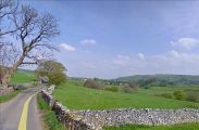
The sheep are grazing in Robin Hood Close aka Robin Hood's Pasture / Google Earth Street View.
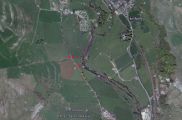
The most southerly red dot indicates Robin Hood Close. That to the left above indicates the possible, that to the right the probable, location of Robin Hood's Mill / Google Earth.