Robin Hood Bridge (Rotherham): Difference between revisions
From International Robin Hood Bibliography
m (Text replacement - "|service=leaflet}}" to "|service=leaflet|enablefullscreen=yes}}") |
m (Text replacement - "PnItemAlsoSee" to "PlaceNamesItemAlsoSee") |
||
| (9 intermediate revisions by the same user not shown) | |||
| Line 1: | Line 1: | ||
__NOTOC__{{ | __NOTOC__{{PlaceNamesItemTop|Lat=53.4351|Lon=-1.3683|AdministrativeDivision=Yorkshire|Vicinity=In Rotherham, connects Rodger Street and Tenter Street|Type=Thoroughfare|Interest=Robin Hood name|Status=Extant|Demonym=|Riding=West|GreaterLondon=|Year=1854|Aka=|Century=|Cluster1=Rotherham|Cluster2=|Cluster3=|Image=google-earth-on-robin-hood-bridge-rotherham.jpg|Postcards=|ExtraCat1=Places named Robin Hood's Bridge|ExtraCat2=|ExtraCat3=|ExtraCat4=|ExtraCat5=|GeopointPrefix=|GeopointSuffix=|StatusSuffix=|DatePrefix=|DateSuffix=}} | ||
{{#display_map:{{#var:Coords}}~{{#replace:{{PAGENAME}}|'|'}}|width=34% | {{#display_map:{{#var:Coords}}~{{#replace:{{PAGENAME}}|'|'}}|width=34%|enablefullscreen=yes}}<div class="pnMapLegend">Robin Hood Bridge.</div> | ||
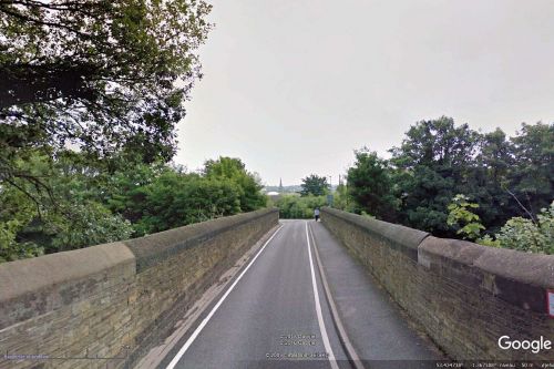
[[File:google-earth-on-robin-hood-bridge-rotherham.jpg|thumb|right|500px|Robin Hood Bridge from the west / Google Earth Street View.]] | [[File:google-earth-on-robin-hood-bridge-rotherham.jpg|thumb|right|500px|Robin Hood Bridge from the west / Google Earth Street View.]] | ||
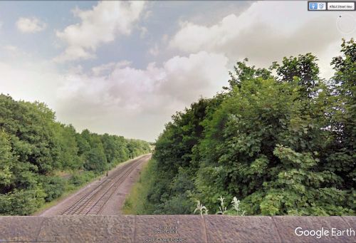
[[File:google-earth-on-robin-hood-bridge-rotherham-2.jpg|thumb|right|500px|Looking NNE from Robin Hood Bridge / Google Earth Street View.]] | [[File:google-earth-on-robin-hood-bridge-rotherham-2.jpg|thumb|right|500px|Looking NNE from Robin Hood Bridge / Google Earth Street View.]]<div class="no-img"> | ||
<p id="byline">By Henrik Thiil Nielsen, 2017-01-07. Revised by {{#realname:{{REVISIONUSER}}}}, {{REVISIONYEAR}}-{{REVISIONMONTH}}-{{REVISIONDAY2}}.</p> | <p id="byline">By Henrik Thiil Nielsen, 2017-01-07. Revised by {{#realname:{{REVISIONUSER}}}}, {{REVISIONYEAR}}-{{REVISIONMONTH}}-{{REVISIONDAY2}}.</p> | ||
Robin Hood Bridge takes Rodger Street over the railway tracks to meet Tenter Street in Rotherham. The earliest record I have found of it is the 6" O.S. map of the area published in 1854, based on surveying carried out 1850-51.<ref>[http://maps.nls.uk/view/102345199#zoom=7&lat=5435&lon=7370&layers=BT 6" O.S. map ''Yorkshire'' 289 (1854; surveyed 1850-51).]</ref> The line, then called the North Midland Railway<ref>[https://en.wikipedia.org/wiki/North_Midland_Railway Wikipedia: North Midland Railway.]</ref> opened in 1840, so the bridge cannot very well be much older than that. Formerly there was a public house named [[Robin Hood (Rotherham)|Robin Hood]] on the north side of Rodger Steert, ''c.'' 50 m west of the bridge. | Robin Hood Bridge takes Rodger Street over the railway tracks to meet Tenter Street in Rotherham. The earliest record I have found of it is the 6" O.S. map of the area published in 1854, based on surveying carried out 1850-51.<ref>[http://maps.nls.uk/view/102345199#zoom=7&lat=5435&lon=7370&layers=BT 6" O.S. map ''Yorkshire'' 289 (1854; surveyed 1850-51).]</ref> The line, then called the North Midland Railway<ref>[https://en.wikipedia.org/wiki/North_Midland_Railway Wikipedia: North Midland Railway.]</ref> opened in 1840, so the bridge cannot very well be much older than that. Formerly there was a public house named [[Robin Hood (Rotherham)|Robin Hood]] on the north side of Rodger Steert, ''c.'' 50 m west of the bridge. | ||
<!--== Allusions == | <!--== Allusions == | ||
| Line 21: | Line 20: | ||
* [https://en.wikipedia.org/wiki/North_Midland_Railway Wikipedia: North Midland Railway.] | * [https://en.wikipedia.org/wiki/North_Midland_Railway Wikipedia: North Midland Railway.] | ||
{{ | {{PlaceNamesItemAlsoSee}} | ||
== Notes == | == Notes == | ||
| Line 29: | Line 28: | ||
</div> | </div> | ||
{{ | {{PlaceNamesItemNavigation}} | ||
Latest revision as of 00:42, 6 January 2021
| Locality | |
|---|---|
| Coordinate | 53.4351, -1.3683 |
| Adm. div. | West Riding of Yorkshire |
| Vicinity | In Rotherham, connects Rodger Street and Tenter Street |
| Type | Thoroughfare |
| Interest | Robin Hood name |
| Status | Extant |
| First Record | 1854 |
Robin Hood Bridge.
By Henrik Thiil Nielsen, 2017-01-07. Revised by Henrik Thiil Nielsen, 2021-01-06.
Robin Hood Bridge takes Rodger Street over the railway tracks to meet Tenter Street in Rotherham. The earliest record I have found of it is the 6" O.S. map of the area published in 1854, based on surveying carried out 1850-51.[1] The line, then called the North Midland Railway[2] opened in 1840, so the bridge cannot very well be much older than that. Formerly there was a public house named Robin Hood on the north side of Rodger Steert, c. 50 m west of the bridge.
Gazetteers
- Not included in Dobson, R. B., ed.; Taylor, J., ed. Rymes of Robyn Hood: an Introduction to the English Outlaw (London, 1976), pp. 293-311.
Maps
- 6" O.S. map Yorkshire 289 (1854; surveyed 1850-51)
- 6" O.S. map Yorkshire CCLXXXIX.SW (1906; rev. 1901-1902)
- 6" O.S. map Yorkshire CCLXXXIX.SW (1924; rev. 1921)
- 6" O.S. map Yorkshire CCLXXXIX (1924; rev. 1921-22)
- 6" O.S. map Yorkshire CCLXXXIX (1934; rev. 1934-35) [sic].
Background
Also see
Notes


