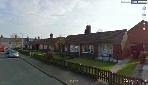
Robin Hood Avenue (Royston, Barnsley)
From International Robin Hood Bibliography
Revision as of 20:28, 7 May 2017 by Henryfunk (talk | contribs) (Text replacement - "Category:Yorkshire place-names " to "")
| Locality | |
|---|---|
| Coordinates | 53.602132, -1.443591 |
| Adm. div. | West Riding of Yorkshire |
| Vicinity | 750 m ESE of center of Royston |
| Type | Thoroughfare |
| Interest | Robin Hood name |
| Status | Extant |
| First Record | ? |
Approximate location of Robin Hood Avenue.
By Henrik Thiil Nielsen, 2014-10-19. Revised by Henrik Thiil Nielsen, 2017-05-07.
Robin Hood Avenue, a street in a residential area in Royston – now a suburban village within the Metropolitan borough of Barnsley, located c. 14 km SW of Wentbridge – runs along the western boundary of an area that was once a field of arable known as 'Robin Hood'.
Gazetteers
- Not included in Dobson, R. B., ed.; Taylor, J., ed. Rymes of Robyn Hood: an Introduction to the English Outlaw (London, 1976), pp. 293-311.
Also see
Template:BeforeNavTemplate:NavTemplate:PreviousWest Riding of Yorkshire place-namesTemplate:BeforeNavTemplate:NavTemplate:Next
Template:BeforeNavTemplate:NavTemplate:PreviousYorkshire place-namesTemplate:BeforeNavTemplate:NavTemplate:Next
Template:BeforeNavTemplate:NavTemplate:PreviousPlace-namesTemplate:BeforeNavTemplate:NavTemplate:Next"?" is not a number.

