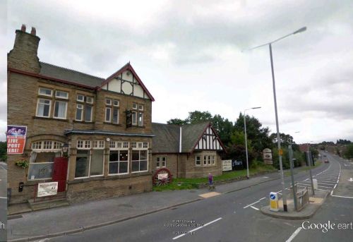
Robin Hood (Wakefield): Difference between revisions
m (Text replacement - "|service=leaflet}}" to "|service=leaflet|enablefullscreen=yes}}") |
mNo edit summary |
||
| Line 4: | Line 4: | ||
<p id="byline">By Henrik Thiil Nielsen, 2013-08-07. Revised by {{#realname:{{REVISIONUSER}}}}, {{REVISIONYEAR}}-{{REVISIONMONTH}}-{{REVISIONDAY2}}.</p> | <p id="byline">By Henrik Thiil Nielsen, 2013-08-07. Revised by {{#realname:{{REVISIONUSER}}}}, {{REVISIONYEAR}}-{{REVISIONMONTH}}-{{REVISIONDAY2}}.</p> | ||
<div class="no-img"> | <div class="no-img"> | ||
According to the well-known place-name specialist A. H. Smith, the first mention of the hamlet or village named Robin Hood c. 2.5 km south-west of Rothwell is found in an 1841 MS Tithe Award.<ref>{{:Smith, Albert Hugh 1961a}}, pt. II, p. 138</ref> Dobson & Taylor refer to an O.S. map from the same year.<ref>{{:Dobson, Richard Barrie 1976a}}, p. 308.</ref> IRHB has not yet been able to locate the tithe award, unless Smith was in fact referring to the map drawn in 1841 for the tithe award, dating from 1838-41, for the neighbouring township of Lofthouse in the parish of Rothwell. This includes 'Robin Hood Quarry', in the main map as well as an insert.<ref>1841 tithe map for the township of Lofthouse in the Parish of Rothwell, online at the [https://www.thegenealogist.com/ Genealogist.co.uk], piece 43, sub-piece 268, image 207 (subscription required).</ref> A quarry is of course not quite a village but it may have lent its name to the small community that came into being when, according to a (local) contributor to Wikipedia, a mine was opened in the mid-19th century and miners settled in the neighbourhood.<ref>[http://en.wikipedia.org/wiki/Robin_Hood,_West_Yorkshire Wikipedia: Robin Hood, West Yorkshire], apparently written by someone connected with the area.</ref> The mine closed in the 1960s, and the village is now a residential area. Several localities in the area are/were named after Robin Hood (the village and/or the outlaw).{{PnItemQry}} | |||
== Gazetteers == | == Gazetteers == | ||
* {{:Dobson, Richard Barrie 1976a}}, p. 308, ''s.n.'' 'Robin Hood'. | * {{:Dobson, Richard Barrie 1976a}}, p. 308, ''s.n.'' 'Robin Hood'. | ||
| Line 13: | Line 12: | ||
== Background == | == Background == | ||
* 1841 tithe map for the township of Lofthouse in the Parish of Rothwell, online at the [https://www.thegenealogist.com/ Genealogist.co.uk], piece 43, sub-piece 268, image 207 (subscription required). | |||
* [http://en.wikipedia.org/wiki/Robin_Hood,_West_Yorkshire Wikipedia: Robin Hood, West Yorkshire]; brief but useful on the village, but the discussion of its alleged Robin Hood associations is misguided. | * [http://en.wikipedia.org/wiki/Robin_Hood,_West_Yorkshire Wikipedia: Robin Hood, West Yorkshire]; brief but useful on the village, but the discussion of its alleged Robin Hood associations is misguided. | ||
{{PnItemAlsoSee}} | {{PnItemAlsoSee}} | ||
Revision as of 02:11, 26 April 2020
By Henrik Thiil Nielsen, 2013-08-07. Revised by Henrik Thiil Nielsen, 2020-04-26.
According to the well-known place-name specialist A. H. Smith, the first mention of the hamlet or village named Robin Hood c. 2.5 km south-west of Rothwell is found in an 1841 MS Tithe Award.[1] Dobson & Taylor refer to an O.S. map from the same year.[2] IRHB has not yet been able to locate the tithe award, unless Smith was in fact referring to the map drawn in 1841 for the tithe award, dating from 1838-41, for the neighbouring township of Lofthouse in the parish of Rothwell. This includes 'Robin Hood Quarry', in the main map as well as an insert.[3] A quarry is of course not quite a village but it may have lent its name to the small community that came into being when, according to a (local) contributor to Wikipedia, a mine was opened in the mid-19th century and miners settled in the neighbourhood.[4] The mine closed in the 1960s, and the village is now a residential area. Several localities in the area are/were named after Robin Hood (the village and/or the outlaw).Template:PnItemQry
Gazetteers
- Dobson, R. B., ed.; Taylor, J., ed. Rymes of Robyn Hood: an Introduction to the English Outlaw (London, 1976), p. 308, s.n. 'Robin Hood'.
Sources
- Smith, A.H. The Place-Names of the West Riding of Yorkshire (English Place-Name Society, vols. XXX-XXXVII) (Cambridge, 1961-63), pt. II, p. 138.
Background
- 1841 tithe map for the township of Lofthouse in the Parish of Rothwell, online at the Genealogist.co.uk, piece 43, sub-piece 268, image 207 (subscription required).
- Wikipedia: Robin Hood, West Yorkshire; brief but useful on the village, but the discussion of its alleged Robin Hood associations is misguided.
Notes
- ↑ Smith, A.H. The Place-Names of the West Riding of Yorkshire (English Place-Name Society, vols. XXX-XXXVII) (Cambridge, 1961-63), pt. II, p. 138
- ↑ Dobson, R. B., ed.; Taylor, J., ed. Rymes of Robyn Hood: an Introduction to the English Outlaw (London, 1976), p. 308.
- ↑ 1841 tithe map for the township of Lofthouse in the Parish of Rothwell, online at the Genealogist.co.uk, piece 43, sub-piece 268, image 207 (subscription required).
- ↑ Wikipedia: Robin Hood, West Yorkshire, apparently written by someone connected with the area.

