|
|
| Line 1: |
Line 1: |
| __NOTOC__ | | __NOTOC__{{PnItemTop|Lat=53.741278|Lon=-1.508186|AdmDiv=Yorkshire|Vicinity=c. 2.5 km SW of Rothwell|Type=Settlement|Interest=Robin Hood name|Status=Extant|Demonym=|Riding=West|GreaterLondon=|Year=1841|Aka=|Century=|Cluster1=|Cluster2=|Cluster3=|Image=robin hood rothwell.jpg|Postcards=|ExtraCat1=|ExtraCat2=|ExtraCat3=|ExtraCat4=|ExtraCat5=|GeopointPrefix=|GeopointSuffix=|VicinitySuffix=|StatusSuffix=|DatePrefix=|DateSuffix=}} |
| {{Infobox | | {{#display_map:{{#var:Coords}}|width=34%}}<div class="pnMapLegend">Robin Hood.</div> |
| |header1=Locality
| |
| |label2=Coordinates
| |
| |data2=[[Geopoint::53.741278,-1.508186]]
| |
| |label3=Adm. div.
| |
| |data3=[[pnadmdiv::West Riding of Yorkshire]]
| |
| |label4=Vicinity
| |
| |data4=[[pnvicinity::c. 2.5 km SW of Rothwell]]
| |
| |label5=Type
| |
| |data5=[[pntype::Settlement]]
| |
| |label6=Interest
| |
| |data6=[[pninterest::Robin Hood name]]
| |
| |label7=Status
| |
| |data7=[[pnstatus::Extant]]
| |
| |label8=First Record
| |
| |data8=[[pnfirstrecord::1841]]
| |
| }} | |
| {{#display_map:53.741278,-1.508186|width=34%}}<div class="pnMapLegend">Robin Hood.</div> | |
| [[File:robin hood rothwell.jpg|500px|thumb|right|Street view in center of Robin Hood (photo: Google Earth)]] | | [[File:robin hood rothwell.jpg|500px|thumb|right|Street view in center of Robin Hood (photo: Google Earth)]] |
| <p id="byline">By Henrik Thiil Nielsen, 2013-08-07. Revised by {{#realname:{{REVISIONUSER}}}}, {{REVISIONYEAR}}-{{REVISIONMONTH}}-{{REVISIONDAY2}}.</p><div class="no-img"> | | <p id="byline">By Henrik Thiil Nielsen, 2013-08-07. Revised by {{#realname:{{REVISIONUSER}}}}, {{REVISIONYEAR}}-{{REVISIONMONTH}}-{{REVISIONDAY2}}.</p><div class="no-img"> |
| Line 38: |
Line 21: |
|
| |
|
|
| |
|
| </div> | | </div><!-- |
| <div id="dplcatlinks" class="subcategory"><div id="dplcatarea"> | | {{ImgGalleryIntro}} |
| {{#ask: [[Category:English place-names]]
| | <gallery widths="195px"> |
| [[Category:English place-names]]
| | FOR EACH IMAGE: File:_FILENAME.jpg|_LEGEND / [_URL _PHOTOGRAPHER, _DAY _MON. _YEAR, Creative Commons.] |
| [[Category:West Riding of Yorkshire place-names]][[Utitle::<<{{#replace:{{uc:{{PAGENAME}}}}|'|'}}]]|order=descending|searchlabel=|format=template|introtemplate=BeforeNav|template=Nav|outrotemplate=Previous|link=none|limit=1|sort=Utitle}}[[West Riding of Yorkshire place-names]]{{#ask: [[Category:English place-names]]
| | </gallery>--> |
| [[Category:English place-names]]
| |
| [[Category:West Riding of Yorkshire place-names]][[Utitle::>>{{#replace:{{uc:{{PAGENAME}}}}|'|'}}]]|order=ascending|searchlabel=|format=template|introtemplate=BeforeNav|template=Nav|outrotemplate=Next|link=none|limit=1|sort=Utitle}}
| |
|
| |
|
| <p>{{#ask: [[Category:English place-names]][[Utitle::<<{{#replace:{{uc:{{PAGENAME}}}}|'|'}}]]|order=descending|searchlabel=|format=template|introtemplate=BeforeNav|template=Nav|outrotemplate=Previous|link=none|limit=1|sort=Utitle}}[[Yorkshire place-names]]{{#ask: [[Category:English place-names]][[Utitle::>>{{#replace:{{uc:{{PAGENAME}}}}|'|'}}]]|order=ascending|searchlabel=|format=template|introtemplate=BeforeNav|template=Nav|outrotemplate=Next|link=none|limit=1|sort=Utitle}}</p>
| | {{PnItemNav}} |
| | |
| {{#ask: [[Category:English place-names]][[Utitle::<<{{#replace:{{uc:{{PAGENAME}}}}|'|'}}]]|order=descending|searchlabel=|format=template|introtemplate=BeforeNav|template=Nav|outrotemplate=Previous|link=none|limit=1|sort=Utitle}}[[Place-names]]{{#ask: [[Category:English place-names]][[Utitle::>>{{#replace:{{uc:{{PAGENAME}}}}|'|'}}]]|order=ascending|searchlabel=|format=template|introtemplate=BeforeNav|template=Nav|outrotemplate=Next|link=none|limit=1|sort=Utitle}}</div></div>
| |
| [[Category:English place-names]]
| |
| [[Category:English place-names]]
| |
| [[Category:West Riding of Yorkshire place-names]]
| |
| [[Category:Place-names-topics]]
| |
| [[Category:Robin Hood place-name cluster]]
| |
| [[Category:Wakefield place-name cluster]]
| |
| [[Category:19th century]]
| |
| {{#set:century=19th}}
| |
| {{#set:Utitle={{#replace:{{uc:{{PAGENAME}}}}|'|'}}}}
| |
| {{#set:Pnimage=robin hood rothwell.jpg}}
| |
| {{#set:Pnimage=robin hood rothwell.jpg}}
| |
Template:PnItemTop
Loading map...
{"minzoom":false,"maxzoom":false,"mappingservice":"leaflet","width":"34%","height":"400px","centre":false,"title":"","label":"","icon":"","lines":[],"polygons":[],"circles":[],"rectangles":[],"copycoords":false,"static":false,"zoom":false,"defzoom":9,"layers":["OpenStreetMap","NLS","Stamen.Terrain"],"image layers":[],"overlays":[],"resizable":false,"fullscreen":false,"scrollwheelzoom":true,"cluster":false,"clustermaxzoom":20,"clusterzoomonclick":true,"clustermaxradius":80,"clusterspiderfy":true,"geojson":"","clicktarget":"","imageLayers":[],"locations":[],"imageoverlays":null}
Robin Hood.
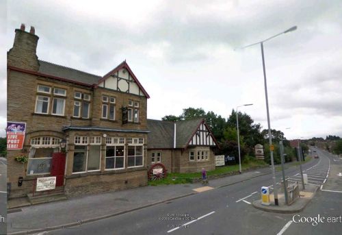
Street view in center of Robin Hood (photo: Google Earth)
By Henrik Thiil Nielsen, 2013-08-07. Revised by Henrik Thiil Nielsen, 2017-12-06.
The first mention of a hamlet or village named Robin Hood c. 2.5 km south-west of Rothwell is found in an 1841 MS Tithe Award.[1] Dobson & Taylor refer to an O.S. map from the same year.[2] The village grew after a mine was opened there in the mid-19th century and miners settled in the neighbourhood. The mine closed in the 1960s; the village is now a residential area. Several localities in the area are/were named after Robin Hood (the village and/or the outlaw).
Gazetteers
Sources
Background
Also see
Notes
- ↑ Smith, A.H. The Place-Names of the West Riding of Yorkshire (English Place-Name Society, vols. XXX-XXXVII) (Cambridge, 1961-63), pt. II, p. 138
- ↑ Dobson, R. B., ed.; Taylor, J., ed. Rymes of Robyn Hood: an Introduction to the English Outlaw (London, 1976), p. 308.
Template:PnItemNav

