
Robin Hood (Tring): Difference between revisions
m (Text replacement - "{{#display_map:{{#var:Coords}}~{{#replace:{{PAGENAME}}|'|'}}|width=34%}}<div class="pnMapLegend">" to "{{#display_map:{{#var:Coords}}~{{#replace:{{PAGENAME}}|'|'}}|width=34%|service=leaflet}}<div class="pnMapLegend">") |
m (Text replacement - "|service=leaflet}}" to "|service=leaflet|enablefullscreen=yes}}") |
||
| Line 1: | Line 1: | ||
__NOTOC__{{PnItemTop|Lat=51.794802|Lon=-0.658237|AdmDiv=Hertfordshire|Vicinity=1 Brook Street, Tring|Type=Public house|Interest=Robin Hood name|Status=Extant|Demonym=|Riding=|GreaterLondon=|Year=1851|Aka=Old Robin Hood|Century=|Cluster1=|Cluster2=|Cluster3=|Image=geograph-1573822-by-Gerald-Massey.jpg|Postcards=|ExtraCat1=|ExtraCat2=|ExtraCat3=|ExtraCat4=|ExtraCat5=|ExtraLink1=|ExtraLink2=|ExtraLink3=|ExtraLink4=|ExtraLink5=|ExtraLinkName1=|ExtraLinkName2=|ExtraLinkName3=|ExtraLinkName4=|ExtraLinkName5=|GeopointPrefix=|GeopointSuffix=|StatusSuffix=|DatePrefix=|DateSuffix=}} | __NOTOC__{{PnItemTop|Lat=51.794802|Lon=-0.658237|AdmDiv=Hertfordshire|Vicinity=1 Brook Street, Tring|Type=Public house|Interest=Robin Hood name|Status=Extant|Demonym=|Riding=|GreaterLondon=|Year=1851|Aka=Old Robin Hood|Century=|Cluster1=|Cluster2=|Cluster3=|Image=geograph-1573822-by-Gerald-Massey.jpg|Postcards=|ExtraCat1=|ExtraCat2=|ExtraCat3=|ExtraCat4=|ExtraCat5=|ExtraLink1=|ExtraLink2=|ExtraLink3=|ExtraLink4=|ExtraLink5=|ExtraLinkName1=|ExtraLinkName2=|ExtraLinkName3=|ExtraLinkName4=|ExtraLinkName5=|GeopointPrefix=|GeopointSuffix=|StatusSuffix=|DatePrefix=|DateSuffix=}} | ||
{{#display_map:{{#var:Coords}}~{{#replace:{{PAGENAME}}|'|'}}|width=34%|service=leaflet}}<div class="pnMapLegend">The Robin Hood.</div> | {{#display_map:{{#var:Coords}}~{{#replace:{{PAGENAME}}|'|'}}|width=34%|service=leaflet|enablefullscreen=yes}}<div class="pnMapLegend">The Robin Hood.</div> | ||
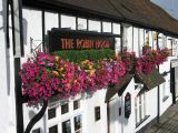
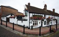
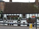
[[File:{{#var:Pnimage}}|thumb|right|500px|The "Robin Hood", Tring / [http://www.geograph.org.uk/photo/1573822 Gerald Massey, 26 Oct. 2009, Creative Commons via Geograph.]]] | [[File:{{#var:Pnimage}}|thumb|right|500px|The "Robin Hood", Tring / [http://www.geograph.org.uk/photo/1573822 Gerald Massey, 26 Oct. 2009, Creative Commons via Geograph.]]] | ||
<p id="byline">By Henrik Thiil Nielsen, 2013-08-07. Revised by {{#realname:{{REVISIONUSER}}}}, {{REVISIONYEAR}}-{{REVISIONMONTH}}-{{REVISIONDAY2}}.</p> | <p id="byline">By Henrik Thiil Nielsen, 2013-08-07. Revised by {{#realname:{{REVISIONUSER}}}}, {{REVISIONYEAR}}-{{REVISIONMONTH}}-{{REVISIONDAY2}}.</p> | ||
Revision as of 20:01, 5 April 2019
[[File:|thumb|right|500px|The "Robin Hood", Tring / Gerald Massey, 26 Oct. 2009, Creative Commons via Geograph.]]
By Henrik Thiil Nielsen, 2013-08-07. Revised by Henrik Thiil Nielsen, 2019-04-05.
Betwen them the pub's unusually informative website and the UK Pub History site provide a good deal of information on publicans and residents during the years 1841 to 1937.[3]Template:PnItemQry
Gazetteers
- Not included in Dobson, R. B., ed.; Taylor, J., ed. Rymes of Robyn Hood: an Introduction to the English Outlaw (London, 1976), pp. 293-311.
Sources
Maps
- 25" O.S. map Hertfordshire XXV.14 (c. 1879; surveyed 1877). No Copy in NLS
- 25" O.S. map Hertfordshire XXV.14 (1899; rev. 1897) (georeferenced)
- 25" O.S. map Hertfordshire XXV.14 (1899; rev. 1897)
- 25" O.S. map Hertfordshire XXV.14 (1924; rev. 1922)
- 6" O.S. map Buckinghamshire XXXIV (1883-84; surveyed 1877)
- 6" O.S. map Hertfordshire XXV (1884; surveyed 1877-79)
- 6" O.S. map Buckinghamshire XXXIV.NE (1900; rev. 1897-98) (georeferenced)
- 6" O.S. map Buckinghamshire XXXIV.NE (1900; rev. 1897-98)
- 6" O.S. map Hertfordshire XXV.SW (1900; rev. 1897)
- 6" O.S. map Hertfordshire XXV.SW (1926; rev. 1922-23)
- 6" O.S. map Hertfordshire XXV.SW (c. 1948; rev. 1938)
- 6" O.S. map Hertfordshire XXV.SW (1952; rev. 1950).
Background
- Facebook: The Robin Hood, Tring
- The Robin Hood, Tring: Gallery; exteriors and interiors of recent date.
Notes
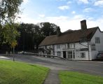
The "Robin Hood", Tring / Gerald Massey, 26 Oct. 2009, Creative Commons via Geograph.
The "Robin Hood", Tring / Gerald Massey, 12 Sep. 2009, Creative Commons via Geograph.
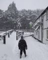
The Robin Hood and snowy footpath / Rob Farrow, 8 Feb. 2007, Creative Commons via Geograph.
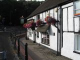
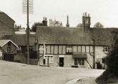
Robin Hood Pub, Tring. At the corner of the Lower High Street and Brook Street / Gerald Massey, 12 Sep. 2009, Creative Commons via Geograph.
The Robin Hood from the Memorial Gardens, Tring / Rob Farrow, 8 Feb. 2007, Creative Commons via Geograph.
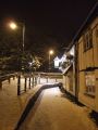
Pavement past the Robin Hood / Rob Farrow, 20 Jan. 2013, Creative Commons via Geograph.
Robin Hood Pub, Tring. At the corner of the Lower High Street and Brook Street / Gerald Massey, 12 Sep. 2009, Creative Commons via Geograph.
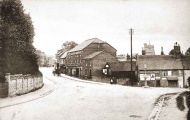
The Robin Hood c. 1900 / Pub website.
The Robin Hood c. 1905 / Pub website.
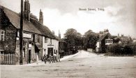
The Robin Hood c. 1905 / Pub website.
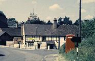
The Robin Hood c. 1960s / Pub website.
The Robin Hood c. 1999 / Pub website.
The Robin Hood c. 2005 / Pub website.


