
Robin Hood (Swinton)
From International Robin Hood Bibliography
The Robin Hood.
[[File:|thumb|right|500px|The Robin Hood / David Dixon, 21 Mar. 2010, Creative Commons via Geograph.]]
By Henrik Thiil Nielsen, 2013-08-07. Revised by Henrik Thiil Nielsen, 2019-02-26.
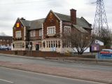
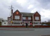
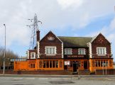
A pub on 180 Manchester Road in Swinton, just south of Clifton, is named the Robin Hood.
The pub is included in a 6" O.S. map of the area published in 1850, based of a survey carried out 1844-46 (see Maps below).
Gazetteers
- Not included in Dobson, R. B., ed.; Taylor, J., ed. Rymes of Robyn Hood: an Introduction to the English Outlaw (London, 1976), pp. 293-11.
Maps
- 6" O.S. map Lancashire XCV (1850; surveyed 1844-46)
- 6" O.S. map Lancashire XCV.SE (1894; surveyed 1889-91)
- 6" O.S. map Lancashire XCV.SE (1910; rev. 1907) (georeferenced)
- 6" O.S. map Lancashire XCV.SE (1910; rev. 1907)
- 6" O.S. map Lancashire XCV.SE (1930; rev. 1926-27)
- 6" O.S. map Lancashire XCV.SE (1936; rev. 1936-37)
- 6" O.S. map Lancashire XCV.SE (1947; rev. 1938)
- 25" O.S. map Lancashire XCV.12 (1893; surveyed 1891)
- 25" O.S. map Lancashire XCV.12 (1909; rev. 1907) (georeferenced)
- 25" O.S. map Lancashire XCV.12 (1909; rev. 1907)
- 25" O.S. map Lancashire XCV.12 (1928; rev. 1927)
- 25" O.S. map Lancashire XCV.12 (1938; rev. 1937).
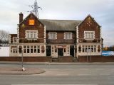
The Robin Hood / David Dixon, 21 Mar. 2010, Creative Commons via Geograph.
The Robin Hood / David Dixon, 21 Mar. 2010, Creative Commons via Geograph.
The Robin Hood / Steve Fareham 26 Mar. 2009, Creative Commons via Geograph.
The Robin Hood / Phillip Platt, 25 Feb. 2014, Creative Commons via Geograph.
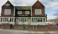
The Robin Hood, Swinton, Manchester / Google Earth Street View.
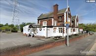
The Robin Hood, Swinton, Manchester / Google Earth Street View.


