
Robin Hood (Swinton): Difference between revisions
m (→Maps) |
m (Text replacement - "ImgGalleryIntro" to "ImageGalleryIntroduction") |
||
| (24 intermediate revisions by 2 users not shown) | |||
| Line 1: | Line 1: | ||
__NOTOC__{{ | __NOTOC__{{PlaceNamesItemTop|Lat=53.525817|Lon=-2.337158|AdministrativeDivision=Lancashire|Vicinity=180 Manchester Road, Swinton, Manchester|Type=Public house|Interest=Robin Hood name|Status=Extant|Demonym=|Riding=|GreaterLondon=|Year=1850|Aka=|Century=|Cluster1=Swinton|Cluster2=Manchester|Cluster3=|Image=geograph-1765830-by-David-Dixon.jpg|Postcards=|ExtraCat1=|ExtraCat2=|ExtraCat3=|ExtraCat4=|ExtraCat5=|ExtraLink1=|ExtraLink2=|ExtraLink3=|ExtraLink4=|ExtraLink5=|ExtraLinkName1=|ExtraLinkName2=|ExtraLinkName3=|ExtraLinkName4=|ExtraLinkName5=|GeopointPrefix=|GeopointSuffix=|StatusSuffix=|DatePrefix=|DateSuffix=}} | ||
{{#display_map:{{#var:Coords}}~{{#replace:{{PAGENAME}}|'|'}}|width=34%}}<div class="pnMapLegend">The Robin Hood.</div> | {{#display_map:{{#var:Coords}}~{{#replace:{{PAGENAME}}|'|'}}|width=34%|enablefullscreen=yes}}<div class="pnMapLegend">The Robin Hood.</div> | ||
[[File:{{#var: | [[File:{{#var:Image}}|thumb|right|500px|The Robin Hood / [https://www.geograph.org.uk/photo/1765830 David Dixon, 21 Mar. 2010, Creative Commons, via Geograph.]]]<div class="no-img"> | ||
<p id="byline">By Henrik Thiil Nielsen, 2013-08-07. Revised by {{#realname:{{REVISIONUSER}}}}, {{REVISIONYEAR}}-{{REVISIONMONTH}}-{{REVISIONDAY2}}.</p | <p id="byline">By Henrik Thiil Nielsen, 2013-08-07. Revised by {{#realname:{{REVISIONUSER}}}}, {{REVISIONYEAR}}-{{REVISIONMONTH}}-{{REVISIONDAY2}}.</p>A pub on 180 Manchester Road in Swinton, just south of Clifton, is named the Robin Hood. | ||
The pub is included | The pub is included on a 6" O.S. map of the area published in 1850, based of a survey carried out 1844-46 (see Maps below). Dating from the 1930s, the present building was built on a bowling green that had belonged to the old pub. The pub's history went much further back, however, for already in 1739 a local Robin Hood Farm was operating an ale house, believed to have been the first in Clifton. In 1840 a new pub had been built and a brewhouse added. Clifton's bowling, football, and fishing clubs all used the pub as their headquarters.<ref>[http://pubs-of-manchester.blogspot.com/2015/01/robin-hood-manchester-road.html Pubs of Manchester, Past & Present: Robin Hood, Manchester Road.]</ref> In 1900, "the annual show of the Clifton Gooseberry and Horticultural Society was held at the Robin Hood Hotel, Clifton".<ref>[https://sites.google.com/site/irememberwhensalford/clive-s-memories I remember when Salford...: Clive's Memories.]</ref> | ||
== Gazetteers == | == Gazetteers == | ||
| Line 11: | Line 10: | ||
== Maps == | == Maps == | ||
* [https://maps.nls.uk/view/126521636#zoom=4&lat=1474&lon=3384&layers=BT 25" O.S. map ''Lancashire'' XCV.12 (1893; surveyed 1891)] | |||
* [https://maps.nls.uk/geo/explore/#zoom=17&lat=53.5261&lon=-2.3372&layers=168&b=5 25" O.S. map ''Lancashire'' XCV.12 (1909; rev. 1907)] (georeferenced) | |||
* [https://maps.nls.uk/view/126521639#zoom=4&lat=1762&lon=4102&layers=BT 25" O.S. map ''Lancashire'' XCV.12 (1909; rev. 1907)] | |||
* [https://maps.nls.uk/view/126521642#zoom=4&lat=1318&lon=3639&layers=BT 25" O.S. map ''Lancashire'' XCV.12 (1928; rev. 1927)] | |||
* [https://maps.nls.uk/view/126521645#zoom=4&lat=1571&lon=3932&layers=BT 25" O.S. map ''Lancashire'' XCV.12 (1938; rev. 1937)] | |||
* [https://maps.nls.uk/view/102344051#zoom=5&lat=3071&lon=12149&layers=BT 6" O.S. map ''Lancashire'' XCV (1850; surveyed 1844-46)] | * [https://maps.nls.uk/view/102344051#zoom=5&lat=3071&lon=12149&layers=BT 6" O.S. map ''Lancashire'' XCV (1850; surveyed 1844-46)] | ||
* [https://maps.nls.uk/view/101103317#zoom=5&lat=3900&lon=5384&layers=BT 6" O.S. map ''Lancashire'' XCV.SE (1894; surveyed 1889-91)] | * [https://maps.nls.uk/view/101103317#zoom=5&lat=3900&lon=5384&layers=BT 6" O.S. map ''Lancashire'' XCV.SE (1894; surveyed 1889-91)] | ||
| Line 17: | Line 21: | ||
* [https://maps.nls.uk/view/101103311#zoom=4&lat=3853&lon=5323&layers=BT 6" O.S. map ''Lancashire'' XCV.SE (1930; rev. 1926-27)] | * [https://maps.nls.uk/view/101103311#zoom=4&lat=3853&lon=5323&layers=BT 6" O.S. map ''Lancashire'' XCV.SE (1930; rev. 1926-27)] | ||
* [https://maps.nls.uk/view/101103308#zoom=4&lat=3767&lon=5187&layers=BT 6" O.S. map ''Lancashire'' XCV.SE (1936; rev. 1936-37)] | * [https://maps.nls.uk/view/101103308#zoom=4&lat=3767&lon=5187&layers=BT 6" O.S. map ''Lancashire'' XCV.SE (1936; rev. 1936-37)] | ||
* [https://maps.nls.uk/view/101103305#zoom=4&lat=3790&lon=5293&layers=BT 6" O.S. map ''Lancashire'' XCV.SE (1947; rev. 1938)] | * [https://maps.nls.uk/view/101103305#zoom=4&lat=3790&lon=5293&layers=BT 6" O.S. map ''Lancashire'' XCV.SE (1947; rev. 1938).] | ||
== Discussion == | |||
* [ | * [http://pubs-of-manchester.blogspot.com/2015/01/robin-hood-manchester-road.html Pubs of Manchester, Past & Present: Robin Hood, Manchester Road.] | ||
== Background == | |||
* [https://sites.google.com/site/irememberwhensalford/clive-s-memories I remember when Salford...: Clive's Memories.] | |||
{{PlaceNamesItemAlsoSee}} | |||
== Notes == | |||
<references/> | |||
</div> | </div> | ||
{{ | |||
<div id="gallery"> | |||
{{ImageGalleryIntroduction}} | |||
<gallery widths="195px"> | <gallery widths="195px"> | ||
File:geograph-1765830-by-David-Dixon.jpg|The Robin Hood / [https://www.geograph.org.uk/photo/1765830 David Dixon, 21 Mar. 2010, Creative Commons via Geograph.] | File:geograph-1765830-by-David-Dixon.jpg|The Robin Hood / [https://www.geograph.org.uk/photo/1765830 David Dixon, 21 Mar. 2010, Creative Commons, via Geograph.] | ||
File:geograph-1765800-by-David-Dixon.jpg|The Robin Hood / [https://www.geograph.org.uk/photo/1765800 David Dixon, 21 Mar. 2010, Creative Commons via Geograph.] | File:geograph-1765800-by-David-Dixon.jpg|The Robin Hood / [https://www.geograph.org.uk/photo/1765800 David Dixon, 21 Mar. 2010, Creative Commons, via Geograph.] | ||
File:geograph-1222311-by-Steve--Fareham.jpg|The Robin Hood / [https://www.geograph.org.uk/photo/1222311 Steve Fareham 26 Mar. 2009, Creative Commons via Geograph.] | File:geograph-1222311-by-Steve--Fareham.jpg|The Robin Hood / [https://www.geograph.org.uk/photo/1222311 Steve Fareham 26 Mar. 2009, Creative Commons, via Geograph.] | ||
File:geograph-3861891-by-Philip-Platt.jpg|The Robin Hood / [https://www.geograph.org.uk/photo/3861891 Phillip Platt, 25 Feb. 2014, Creative Commons via Geograph.] | File:geograph-3861891-by-Philip-Platt.jpg|The Robin Hood / [https://www.geograph.org.uk/photo/3861891 Phillip Platt, 25 Feb. 2014, Creative Commons, via Geograph.] | ||
File:robin-hood-swinton-google-earth-street-view.jpg|The Robin Hood, Swinton, Manchester / Google Earth Street View. | File:robin-hood-swinton-google-earth-street-view.jpg|The Robin Hood, Swinton, Manchester / Google Earth Street View. | ||
File:robin-hood-swinton-2-google-earth-street-view.jpg|The Robin Hood, Swinton, Manchester / Google Earth Street View. | File:robin-hood-swinton-2-google-earth-street-view.jpg|The Robin Hood, Swinton, Manchester / Google Earth Street View. | ||
</gallery> | </gallery> | ||
</div> | |||
{{ | {{PlaceNamesItemNavigation}} | ||
Latest revision as of 13:53, 7 January 2021
| Locality | |
|---|---|
| Coordinate | 53.525817, -2.337158 |
| Adm. div. | Lancashire |
| Vicinity | 180 Manchester Road, Swinton, Manchester |
| Type | Public house |
| Interest | Robin Hood name |
| Status | Extant |
| First Record | 1850 |

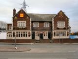
By Henrik Thiil Nielsen, 2013-08-07. Revised by Henrik Thiil Nielsen, 2021-01-07.
A pub on 180 Manchester Road in Swinton, just south of Clifton, is named the Robin Hood.The pub is included on a 6" O.S. map of the area published in 1850, based of a survey carried out 1844-46 (see Maps below). Dating from the 1930s, the present building was built on a bowling green that had belonged to the old pub. The pub's history went much further back, however, for already in 1739 a local Robin Hood Farm was operating an ale house, believed to have been the first in Clifton. In 1840 a new pub had been built and a brewhouse added. Clifton's bowling, football, and fishing clubs all used the pub as their headquarters.[1] In 1900, "the annual show of the Clifton Gooseberry and Horticultural Society was held at the Robin Hood Hotel, Clifton".[2]
Gazetteers
- Not included in Dobson, R. B., ed.; Taylor, J., ed. Rymes of Robyn Hood: an Introduction to the English Outlaw (London, 1976), pp. 293-11.
Maps
- 25" O.S. map Lancashire XCV.12 (1893; surveyed 1891)
- 25" O.S. map Lancashire XCV.12 (1909; rev. 1907) (georeferenced)
- 25" O.S. map Lancashire XCV.12 (1909; rev. 1907)
- 25" O.S. map Lancashire XCV.12 (1928; rev. 1927)
- 25" O.S. map Lancashire XCV.12 (1938; rev. 1937)
- 6" O.S. map Lancashire XCV (1850; surveyed 1844-46)
- 6" O.S. map Lancashire XCV.SE (1894; surveyed 1889-91)
- 6" O.S. map Lancashire XCV.SE (1910; rev. 1907) (georeferenced)
- 6" O.S. map Lancashire XCV.SE (1910; rev. 1907)
- 6" O.S. map Lancashire XCV.SE (1930; rev. 1926-27)
- 6" O.S. map Lancashire XCV.SE (1936; rev. 1936-37)
- 6" O.S. map Lancashire XCV.SE (1947; rev. 1938).
Discussion
Background
Also see
Notes
Image gallery
Click any image to display it in the lightbox, where you can navigate between images by clicking in the right or left side of the current image.
The Robin Hood / David Dixon, 21 Mar. 2010, Creative Commons, via Geograph.
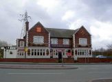
The Robin Hood / David Dixon, 21 Mar. 2010, Creative Commons, via Geograph.
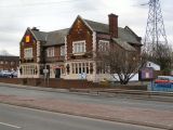
The Robin Hood / Steve Fareham 26 Mar. 2009, Creative Commons, via Geograph.
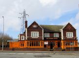
The Robin Hood / Phillip Platt, 25 Feb. 2014, Creative Commons, via Geograph.
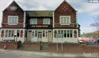
The Robin Hood, Swinton, Manchester / Google Earth Street View.
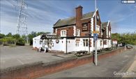
The Robin Hood, Swinton, Manchester / Google Earth Street View.


