
Robin Hood (Swinton): Difference between revisions
m (Text replacement - " in a 6" O.S. map" to " on a 6" O.S. map") |
m (Text replacement - "width=34%|service=leaflet|" to "service=leaflet|width=34%|") |
||
| Line 1: | Line 1: | ||
__NOTOC__{{PnItemTop|Lat=53.525817|Lon=-2.337158|AdmDiv=Lancashire|Vicinity=180 Manchester Road, Swinton, Manchester|Type=Public house|Interest=Robin Hood name|Status=Extant|Demonym=|Riding=|GreaterLondon=|Year=1850|Aka=|Century=|Cluster1=Swinton|Cluster2=Manchester|Cluster3=|Image=geograph-1765830-by-David-Dixon.jpg|Postcards=|ExtraCat1=|ExtraCat2=|ExtraCat3=|ExtraCat4=|ExtraCat5=|ExtraLink1=|ExtraLink2=|ExtraLink3=|ExtraLink4=|ExtraLink5=|ExtraLinkName1=|ExtraLinkName2=|ExtraLinkName3=|ExtraLinkName4=|ExtraLinkName5=|GeopointPrefix=|GeopointSuffix=|StatusSuffix=|DatePrefix=|DateSuffix=}} | __NOTOC__{{PnItemTop|Lat=53.525817|Lon=-2.337158|AdmDiv=Lancashire|Vicinity=180 Manchester Road, Swinton, Manchester|Type=Public house|Interest=Robin Hood name|Status=Extant|Demonym=|Riding=|GreaterLondon=|Year=1850|Aka=|Century=|Cluster1=Swinton|Cluster2=Manchester|Cluster3=|Image=geograph-1765830-by-David-Dixon.jpg|Postcards=|ExtraCat1=|ExtraCat2=|ExtraCat3=|ExtraCat4=|ExtraCat5=|ExtraLink1=|ExtraLink2=|ExtraLink3=|ExtraLink4=|ExtraLink5=|ExtraLinkName1=|ExtraLinkName2=|ExtraLinkName3=|ExtraLinkName4=|ExtraLinkName5=|GeopointPrefix=|GeopointSuffix=|StatusSuffix=|DatePrefix=|DateSuffix=}} | ||
{{#display_map:{{#var:Coords}}~{{#replace:{{PAGENAME}}|'|'}}|width=34% | {{#display_map:{{#var:Coords}}~{{#replace:{{PAGENAME}}|'|'}}|service=leaflet|width=34%|enablefullscreen=yes}}<div class="pnMapLegend">The Robin Hood.</div> | ||
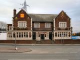
[[File:{{#var:Pnimage}}|thumb|right|500px|The Robin Hood / [https://www.geograph.org.uk/photo/1765830 David Dixon, 21 Mar. 2010, Creative Commons, via Geograph.]]]<div class="no-img"> | [[File:{{#var:Pnimage}}|thumb|right|500px|The Robin Hood / [https://www.geograph.org.uk/photo/1765830 David Dixon, 21 Mar. 2010, Creative Commons, via Geograph.]]]<div class="no-img"> | ||
<p id="byline">By Henrik Thiil Nielsen, 2013-08-07. Revised by {{#realname:{{REVISIONUSER}}}}, {{REVISIONYEAR}}-{{REVISIONMONTH}}-{{REVISIONDAY2}}.</p>A pub on 180 Manchester Road in Swinton, just south of Clifton, is named the Robin Hood. | <p id="byline">By Henrik Thiil Nielsen, 2013-08-07. Revised by {{#realname:{{REVISIONUSER}}}}, {{REVISIONYEAR}}-{{REVISIONMONTH}}-{{REVISIONDAY2}}.</p>A pub on 180 Manchester Road in Swinton, just south of Clifton, is named the Robin Hood. | ||
Revision as of 12:40, 22 December 2020
[[File:|thumb|right|500px|The Robin Hood / David Dixon, 21 Mar. 2010, Creative Commons, via Geograph.]]
By Henrik Thiil Nielsen, 2013-08-07. Revised by Henrik Thiil Nielsen, 2020-12-22.
A pub on 180 Manchester Road in Swinton, just south of Clifton, is named the Robin Hood.The pub is included on a 6" O.S. map of the area published in 1850, based of a survey carried out 1844-46 (see Maps below). Dating from the 1930s, the present building was built on a bowling green that had belonged to the old pub. The pub's history went much further back, however, for already in 1739 a local Robin Hood Farm was operating an ale house, believed to have been the first in Clifton. In 1840 a new pub had been built and a brewhouse added. Clifton's bowling, football, and fishing clubs all used the pub as their headquarters.[1] In 1900, "the annual show of the Clifton Gooseberry and Horticultural Society was held at the Robin Hood Hotel, Clifton".[2]
Gazetteers
- Not included in Dobson, R. B., ed.; Taylor, J., ed. Rymes of Robyn Hood: an Introduction to the English Outlaw (London, 1976), pp. 293-11.
Maps
- 25" O.S. map Lancashire XCV.12 (1893; surveyed 1891)
- 25" O.S. map Lancashire XCV.12 (1909; rev. 1907) (georeferenced)
- 25" O.S. map Lancashire XCV.12 (1909; rev. 1907)
- 25" O.S. map Lancashire XCV.12 (1928; rev. 1927)
- 25" O.S. map Lancashire XCV.12 (1938; rev. 1937)
- 6" O.S. map Lancashire XCV (1850; surveyed 1844-46)
- 6" O.S. map Lancashire XCV.SE (1894; surveyed 1889-91)
- 6" O.S. map Lancashire XCV.SE (1910; rev. 1907) (georeferenced)
- 6" O.S. map Lancashire XCV.SE (1910; rev. 1907)
- 6" O.S. map Lancashire XCV.SE (1930; rev. 1926-27)
- 6" O.S. map Lancashire XCV.SE (1936; rev. 1936-37)
- 6" O.S. map Lancashire XCV.SE (1947; rev. 1938).
Discussion
Background
Notes
The Robin Hood / David Dixon, 21 Mar. 2010, Creative Commons, via Geograph.
The Robin Hood / David Dixon, 21 Mar. 2010, Creative Commons, via Geograph.
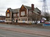
The Robin Hood / Steve Fareham 26 Mar. 2009, Creative Commons, via Geograph.
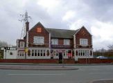
The Robin Hood / Phillip Platt, 25 Feb. 2014, Creative Commons, via Geograph.
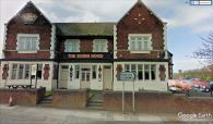
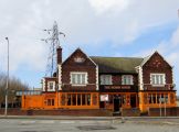
The Robin Hood, Swinton, Manchester / Google Earth Street View.
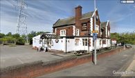
The Robin Hood, Swinton, Manchester / Google Earth Street View.


