
Robin Hood (Sutton): Difference between revisions
From International Robin Hood Bibliography
m (Text replacement - "{{#ask:[[Category:Records ({{#ifeq:{{#pos:{{PAGENAME}}|(|}}||{{PAGENAME}}|{{#sub:{{PAGENAME}}|0| {{#expr:{{#pos:{{PAGENAME}}|(|}}-1}} }},{{#sub:{{PAGENAME}}|{{#expr:{{#pos:{{PAGENAME}}|(|}}-1}}|1}}{{#sub:{{PAGENAME}}|{{#expr:{{#pos:...) |
m (Text replacement - "UK Pub History" to "Pub History") |
||
| (23 intermediate revisions by 2 users not shown) | |||
| Line 1: | Line 1: | ||
__NOTOC__{{ | __NOTOC__{{PlaceNamesItemTop|Lat=51.3634869097423|Lon=-0.1964946732948647|AdministrativeDivision=Surrey|Vicinity=52 West Street, Sutton|Type=Public house|Interest=Robin Hood name|Status=Extant|Demonym=|Riding=|GreaterLondon=Yes|Year=1869|Aka=Robin Hood Inn; Robin Hood Hotel|Century=|Cluster1=Sutton|Cluster2=Robin Hood Lane|Cluster3=|Image=robin-hood-sutton-google-earth-street-view.jpg|Postcards=|ExtraCat1=|ExtraCat2=|ExtraCat3=|ExtraCat4=|ExtraCat5=|ExtraLink1=|ExtraLink2=|ExtraLink3=|ExtraLink4=|ExtraLink5=|ExtraLinkName1=|ExtraLinkName2=|ExtraLinkName3=|ExtraLinkName4=|ExtraLinkName5=|GeopointPrefix=|GeopointSuffix=|StatusSuffix=|DatePrefix=|DateSuffix=}} | ||
{{#display_map:{{#var:Coords}}~{{#replace:{{PAGENAME}}|'|'}}|width=34%}}<div class="pnMapLegend">The Robin Hood Inn.</div> | {{#display_map:{{#var:Coords}}~{{#replace:{{PAGENAME}}|'|'}}|width=34%|enablefullscreen=yes}}<div class="pnMapLegend">The Robin Hood Inn.</div> | ||
[[File:{{#var: | [[File:{{#var:Image}}|500px|thumb|right|The Robin Hood on the Corner of Robin Hood Lane and West Street in Sutton / Google Earth Street View.]]<div class="no-img"> | ||
<p id="byline">By Henrik Thiil Nielsen, 2013-08-07. Revised by {{#realname:{{REVISIONUSER}}}}, {{REVISIONYEAR}}-{{REVISIONMONTH}}-{{REVISIONDAY2}}.</p> | <p id="byline">By Henrik Thiil Nielsen, 2013-08-07. Revised by {{#realname:{{REVISIONUSER}}}}, {{REVISIONYEAR}}-{{REVISIONMONTH}}-{{REVISIONDAY2}}.</p> | ||
The Robin Hood in Sutton is located on the corner of [[Robin Hood Lane (Sutton)|Robin Hood Lane]] and West Street. Its current address is 52 West Street. It has also been known as the Robin Hood Inn, and in 1869 it was listed in a local street directory as Robin Hood Hotel. Pub History lists information on publicans, family members and employees for the period 1869-1918.<ref>[https://pubwiki.co.uk/SurreyPubs/Sutton/RobinHood.shtml Pub History: Robin Hood, West Street, Sutton, Surrey;] also see Sources below.</ref> Sutton is now within Greater London.{{PlaceNamesItemAllusionsAndRecords}} | |||
The Robin Hood in Sutton is located on the corner of [[Robin Hood Lane (Sutton)|Robin Hood Lane]] and West Street. Its current address is 52 West Street. It has also been known as the Robin Hood Inn, and in 1869 it was listed in a local street directory as Robin Hood Hotel. | |||
== Gazetteers == | |||
* Not included in {{:Dobson, Richard Barrie 1976a|Dobson & Taylor}}, pp. 293-311. | |||
== Sources == | == Sources == | ||
* [https:// | * [https://pubwiki.co.uk/SurreyPubs/Sutton/RobinHood.shtml Pub History: Robin Hood, West Street, Sutton, Surrey.]<ref>Also see [https://pubwiki.co.uk/LondonSuburbs1896/Publicans1896SouthR.shtml Pub History: London (South) 1896 Suburban Publicans directory listing - R] and [https://pubwiki.co.uk/London1921/London1921Ro.shtml Pub History: London and Suburbs pubs in 1921 - Hughes directory listing - Ro.]</ref> | ||
== Maps == | |||
* 25" O.S. map ''Surrey'' XIII.15 (''c.'' 1873; surveyed ''c.'' 1866-67). No copy in NLS | |||
* [https://maps.nls.uk/geo/explore/#zoom=17&lat=51.3637&lon=-0.1973&layers=168&b=5 25" O.S. map ''Surrey'' XIII.15 (1896; rev. 1894-95)] (georeferenced) | |||
* [https://maps.nls.uk/view/103314427#zoom=4&lat=10528&lon=9477&layers=BT 25" O.S. map ''Surrey'' XIII.15 (1896; rev. 1894-95)] | |||
* [https://maps.nls.uk/view/103314424#zoom=4&lat=10706&lon=8784&layers=BT 25" O.S. map ''Surrey'' XIII.15 (1913; rev. 1910)] | |||
* [https://maps.nls.uk/view/103314421#zoom=4&lat=10826&lon=9071&layers=BT 25" O.S. map ''Surrey'' XIII.15 (1935; rev. 1933-34)] | |||
* [https://maps.nls.uk/view/102347445#zoom=6&lat=2980&lon=9736&layers=BT 6" O.S. map ''Surrey'' XIII (1871; surveyed 1866-67)] | |||
* [https://maps.nls.uk/geo/explore/#zoom=17&lat=51.3639&lon=-0.1980&layers=6&b=5 6" O.S. map ''Surrey'' XIII.SE (1898; rev. 1894-95)] (georeferenced) | |||
* [https://maps.nls.uk/view/101436688#zoom=5&lat=3459&lon=2795&layers=BT 6" O.S. map ''Surrey'' XIII.SE (1898; rev. 1894-95)] | |||
* [https://maps.nls.uk/view/101436685#zoom=5&lat=3585&lon=2745&layers=BT 6" O.S. map ''Surrey'' XIII.SE (1914; rev. 1910)] | |||
* [https://maps.nls.uk/view/101436682#zoom=5&lat=3725&lon=2828&layers=BT 6" O.S. map ''Surrey'' XIII.SE (1937; rev. 1933-34)] | |||
* [https://maps.nls.uk/view/101436679#zoom=5&lat=3827&lon=2797&layers=BT 6" O.S. map ''Surrey'' XIII.SE (1944; rev. 1938)] | |||
* [https://maps.nls.uk/view/101436676#zoom=5&lat=3696&lon=2880&layers=BT 6" O.S. map ''Surrey'' XIII.SE (''c.'' 1946; rev. 1938).] | |||
== Background == | == Background == | ||
* [http://therobinhoodsutton.co.uk The Robin Hood] (the pub's website). | * [http://therobinhoodsutton.co.uk The Robin Hood] (the pub's website). | ||
{{ | {{PlaceNamesItemAlsoSee}} | ||
== Notes == | == Notes == | ||
<references/> | <references/> | ||
</div> | |||
<div id="gallery"> | |||
< | {{ImageGalleryIntroduction}} | ||
{{ | |||
<gallery widths="195px"> | <gallery widths="195px"> | ||
robin-hood-sutton-google-earth-street-view.jpg|The Robin Hood on the Corner of Robin Hood Lane and West Street in Sutton / Google Earth Street View. | |||
</gallery> | Hartmann, Frederick 1904a-r.jpg|{{:Hartmann, Frederick 1904a}} / HTN collection. | ||
</gallery> | |||
</div> | |||
{{ | {{PlaceNamesItemNavigation}} | ||
Latest revision as of 15:31, 5 May 2022
| Locality | |
|---|---|
| Coordinate | 51.363487, -0.196495 |
| Adm. div. | Surrey, now Greater London |
| Vicinity | 52 West Street, Sutton |
| Type | Public house |
| Interest | Robin Hood name |
| Status | Extant |
| First Record | 1869 |
| A.k.a. | Robin Hood Inn; Robin Hood Hotel |
The Robin Hood Inn.

By Henrik Thiil Nielsen, 2013-08-07. Revised by Henrik Thiil Nielsen, 2022-05-05.
The Robin Hood in Sutton is located on the corner of Robin Hood Lane and West Street. Its current address is 52 West Street. It has also been known as the Robin Hood Inn, and in 1869 it was listed in a local street directory as Robin Hood Hotel. Pub History lists information on publicans, family members and employees for the period 1869-1918.[1] Sutton is now within Greater London.
Gazetteers
- Not included in Dobson, R. B., ed.; Taylor, J., ed. Rymes of Robyn Hood: an Introduction to the English Outlaw (London, 1976), pp. 293-311.
Sources
Maps
- 25" O.S. map Surrey XIII.15 (c. 1873; surveyed c. 1866-67). No copy in NLS
- 25" O.S. map Surrey XIII.15 (1896; rev. 1894-95) (georeferenced)
- 25" O.S. map Surrey XIII.15 (1896; rev. 1894-95)
- 25" O.S. map Surrey XIII.15 (1913; rev. 1910)
- 25" O.S. map Surrey XIII.15 (1935; rev. 1933-34)
- 6" O.S. map Surrey XIII (1871; surveyed 1866-67)
- 6" O.S. map Surrey XIII.SE (1898; rev. 1894-95) (georeferenced)
- 6" O.S. map Surrey XIII.SE (1898; rev. 1894-95)
- 6" O.S. map Surrey XIII.SE (1914; rev. 1910)
- 6" O.S. map Surrey XIII.SE (1937; rev. 1933-34)
- 6" O.S. map Surrey XIII.SE (1944; rev. 1938)
- 6" O.S. map Surrey XIII.SE (c. 1946; rev. 1938).
Background
- The Robin Hood (the pub's website).
Also see
Notes
Image gallery
Click any image to display it in the lightbox, where you can navigate between images by clicking in the right or left side of the current image.
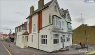
The Robin Hood on the Corner of Robin Hood Lane and West Street in Sutton / Google Earth Street View.
