
Robin Hood (Stretford, Manchester) (1)
From International Robin Hood Bibliography
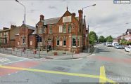
The Robin Hood.
[[File:|thumb|right|500px|The Robin Hood, looking south on Urmston Lane / Google Earth Street View.]]
By Henrik Thiil Nielsen, 2013-08-07. Revised by Henrik Thiil Nielsen, 2019-02-22.
The Robin Hood is a pub at 125 Barton Road, the corner of Urmston Lane/Barton Road), Stretford, Manchester.Template:PnItemQry
Gazetteers
- Not included in Dobson, R. B., ed.; Taylor, J., ed. Rymes of Robyn Hood: an Introduction to the English Outlaw (London, 1976), pp. 293-11.
Maps
- 6" O.S. map Lancashire CX (1848; surveyed 1845)
- 6" O.S. map Lancashire CX.NE (1910; rev. 1904) (georeferenced)
- 6" O.S. map Lancashire CX.NE (1910; rev. 1904)
- 6" O.S. map Lancashire CX.NE (1929; rev. 1926-27)
- 6" O.S. map Lancashire CX.NE (1947; rev. 1938)
- 25" O.S. map Lancashire CX.4 (1907; rev. 1904) (georeferenced)
- 25" O.S. map Lancashire CX.4 (1907; rev. 1904)
- 25" O.S. map Lancashire CX.4 (1928; rev. 1927)
- 25" O.S. map Lancashire CX.4 (1939; rev. 1937-38).

The Robin Hood, looking south on Urmston Lane / Google Earth Street View.
The Robin Hood, looking west on Urmston Lane / Google Earth Street View.

