
Robin Hood (Stretford, Manchester) (1): Difference between revisions
m (→Drawings) |
m (Text replacement - "ImgGalleryIntro" to "ImageGalleryIntroduction") |
||
| (38 intermediate revisions by 2 users not shown) | |||
| Line 1: | Line 1: | ||
__NOTOC__{{ | __NOTOC__{{PlaceNamesItemTop|Lat=53.445970|Lon=-2.314141|AdministrativeDivision=Lancashire|Vicinity=Park Road (formerly Butt Lane), junction of Park Road, King Street and Urmston Lane|Type=Public house|Interest=Robin Hood name|Status=Defunct|Demonym=|Riding=|GreaterLondon=|Year=1845|Aka=|Century=|Cluster1=Stretford, Manchester|Cluster2=Manchester|Cluster3=|Image=Anonymous 19xxzk-r.jpg|Postcards=Yes|ExtraCat1=|ExtraCat2=|ExtraCat3=|ExtraCat4=|ExtraCat5=|ExtraLink1=|ExtraLink2=|ExtraLink3=|ExtraLink4=|ExtraLink5=|ExtraLinkName1=|ExtraLinkName2=|ExtraLinkName3=|ExtraLinkName4=|ExtraLinkName5=|GeopointPrefix=|GeopointSuffix=|StatusSuffix=|DatePrefix=|DateSuffix=}} | ||
{{#display_map:{{#var:Coords}}~{{#replace:{{PAGENAME}}|'|'}}|width=34%}}<div class="pnMapLegend">The Robin Hood.</div> | {{#display_map:{{#var:Coords}}~{{#replace:{{PAGENAME}}|'|'}}|width=34%|enablefullscreen=yes}}<div class="pnMapLegend">The original site of the Robin Hood.</div> | ||
[[File:{{#var: | [[File:{{#var:Image}}|thumb|right|500px|The Robin Hood / {{:Anonymous 19xxzk}}.]]<div class="no-img"> | ||
<p id="byline">By Henrik Thiil Nielsen, 2013- | <p id="byline">By Henrik Thiil Nielsen, 2013-06-11. Revised by {{#realname:{{REVISIONUSER}}}}, {{REVISIONYEAR}}-{{REVISIONMONTH}}-{{REVISIONDAY2}}.</p> | ||
The pub now at 125 Barton Road, Stretford, Manchester, was originally situated on the north-western corner of the junction whose south-western corner it now occupies. | |||
Evidently the inn only became the Robin Hood at some point in the 19th century, for H. T. Crofton noted in 1903 that "[t]he Robin Hood Inn is the modern name for the old Waggon and Horses, and stood on the west side of Butt Lane, which leads from King Street or Urmston Lane towards Derbyshire Lane".<ref>{{:Crofton, H T 1899a}}, vol. III (1903), p. 10.</ref> | For the current pub, see [[Robin Hood (Stretford, Manchester) (2)]]. Evidently the inn only became the Robin Hood at (probably) some point in the 19th century, for H. T. Crofton noted in 1903 that "[t]he Robin Hood Inn is the modern name for the old Waggon and Horses, and stood on the west side of Butt Lane, which leads from King Street or Urmston Lane towards Derbyshire Lane".<ref>{{:Crofton, H T 1899a}}, vol. III (1903), p. 10.</ref> The O.S. maps (see below) tell us that Butt Lane has now, as it were, had its name bowdlerized to 'Park Road'. A citizen born ''c.'' 1816 remembered that "[i]n the roadway at Four Lane Ends, opposite the Waggon and Horses, which was afterwards the Robin Hood, there was an iron ring fixed for bear baiting".<ref>{{:Crofton, H T 1899a}}, vol. III (1903), p. 11, and see p. 14.</ref> | ||
One 19th century keeper active after the pub had become the Robin Hood was named John Hamer<ref>See Drawings below.</ref> ''Slater's Directory'' for 1845 lists Josiah Johnson Smith, victualler", as keeper of the Robin Hood.<ref>{{:Crofton, H T 1899a}}, vol. III, pp. 216, 218.</ref> The O.S. maps listed below include the indication "P.H." for the present pub. An unlabelled building is shown at the old location. The pub had probably moved across Urmston Lane by 1898. See the page on [[Robin Hood (Stretford, Manchester) (2)]].{{PlaceNamesItemAllusionsAndRecords}} | |||
== Gazetteers == | == Gazetteers == | ||
| Line 15: | Line 16: | ||
== Maps == | == Maps == | ||
* [https://maps.nls.uk/ | * [https://maps.nls.uk/geo/explore/#zoom=18&lat=53.4459&lon=-2.3140&layers=168&b=5 25" O.S. map ''Lancashire'' CX.4 (1907; rev. 1904)] (georeferenced) | ||
* [https://maps.nls.uk/ | * [https://maps.nls.uk/view/126523628#zoom=4&lat=6496&lon=14204&layers=BT 25" O.S. map ''Lancashire'' CX.4 (1907; rev. 1904)] | ||
* [https://maps.nls.uk/view/ | * [https://maps.nls.uk/view/126523631#zoom=4&lat=6574&lon=14347&layers=BT 25" O.S. map ''Lancashire'' CX.4 (1928; rev. 1927)] | ||
* [https://maps.nls.uk/view/ | * [https://maps.nls.uk/view/126523634#zoom=4&lat=6458&lon=14217&layers=BT 25" O.S. map ''Lancashire'' CX.4 (1939; rev. 1937-38)] | ||
* [https://maps.nls.uk/view/ | * [https://maps.nls.uk/view/102344108#zoom=5&lat=9130&lon=14653&layers=BT 6" O.S. map ''Lancashire'' CX (1848; surveyed 1845)] | ||
* [https://maps.nls.uk/geo/explore/#zoom= | * [https://maps.nls.uk/geo/explore/#zoom=17&lat=53.4463&lon=-2.3147&layers=6&b=5 6" O.S. map ''Lancashire'' CX.NE (1910; rev. 1904)] (georeferenced) | ||
* [https://maps.nls.uk/view/ | * [https://maps.nls.uk/view/101104139#zoom=5&lat=4990&lon=7791&layers=BT 6" O.S. map ''Lancashire'' CX.NE (1910; rev. 1904)] | ||
* [https://maps.nls.uk/view/ | * [https://maps.nls.uk/view/101104136#zoom=5&lat=5104&lon=7666&layers=BT 6" O.S. map ''Lancashire'' CX.NE (1929; rev. 1926-27)] | ||
* [https://maps.nls.uk/view/ | * [https://maps.nls.uk/view/101104133#zoom=5&lat=5080&lon=7598&layers=BT 6" O.S. map ''Lancashire'' CX.NE (1947; rev. 1938).] | ||
== Drawings == | == Drawings == | ||
* "Mr. John Owen in the 40th volume of his interesting manuscripts, which are in the Manchester Free Library, has made drawings of the following Stretford buildings, copies of some of which illustrate this volume [... including] Robin Hood Inn, kept by John Hamer, at the corner of Urmston Lane". | * "Mr. John Owen in the 40th volume of his interesting manuscripts, which are in the Manchester Free Library, has made drawings of the following Stretford buildings, copies of some of which illustrate this volume [... including] Robin Hood Inn, kept by John Hamer, at the corner of Urmston Lane", cf. {{:Crofton, H T 1899a}}, vol. III (1903), p. 24. | ||
{{ | {{PlaceNamesItemAlsoSee}} | ||
== Notes == | == Notes == | ||
<references/> | <references/> | ||
</div> | </div> | ||
{{ | <div id="gallery"> | ||
{{ImageGalleryIntroduction}} | |||
<gallery widths="195px"> | <gallery widths="195px"> | ||
File: | File:Anonymous 19xxzk-r.jpg|The Robin Hood / {{:Anonymous 19xxzk}} | ||
File: | File:Anonymous 19xxzl-r.jpg|Urmston Lane, opposite the Robin Hood, 1898 / {{:Anonymous 19xxzl}} | ||
File:google-earth-street-view-robin-hood-stretford-1.jpg|Stretford's original Robin Hood was situated around here on what is now Park Road / Google Earth Street View | |||
</gallery> | </gallery> | ||
</div> | |||
{{PlaceNamesItemNavigation}} | |||
{{ | |||
Latest revision as of 13:52, 7 January 2021
| Locality | |
|---|---|
| Coordinate | 53.44597, -2.314141 |
| Adm. div. | Lancashire |
| Vicinity | Park Road (formerly Butt Lane), junction of Park Road, King Street and Urmston Lane |
| Type | Public house |
| Interest | Robin Hood name |
| Status | Defunct |
| First Record | 1845 |

By Henrik Thiil Nielsen, 2013-06-11. Revised by Henrik Thiil Nielsen, 2021-01-07.
The pub now at 125 Barton Road, Stretford, Manchester, was originally situated on the north-western corner of the junction whose south-western corner it now occupies.
For the current pub, see Robin Hood (Stretford, Manchester) (2). Evidently the inn only became the Robin Hood at (probably) some point in the 19th century, for H. T. Crofton noted in 1903 that "[t]he Robin Hood Inn is the modern name for the old Waggon and Horses, and stood on the west side of Butt Lane, which leads from King Street or Urmston Lane towards Derbyshire Lane".[1] The O.S. maps (see below) tell us that Butt Lane has now, as it were, had its name bowdlerized to 'Park Road'. A citizen born c. 1816 remembered that "[i]n the roadway at Four Lane Ends, opposite the Waggon and Horses, which was afterwards the Robin Hood, there was an iron ring fixed for bear baiting".[2]
One 19th century keeper active after the pub had become the Robin Hood was named John Hamer[3] Slater's Directory for 1845 lists Josiah Johnson Smith, victualler", as keeper of the Robin Hood.[4] The O.S. maps listed below include the indication "P.H." for the present pub. An unlabelled building is shown at the old location. The pub had probably moved across Urmston Lane by 1898. See the page on Robin Hood (Stretford, Manchester) (2).
Gazetteers
- Not included in Dobson, R. B., ed.; Taylor, J., ed. Rymes of Robyn Hood: an Introduction to the English Outlaw (London, 1976), pp. 293-11.
Sources
- Crofton, H. T. A History of the Ancient Chapel of Stretford in Manchester Parish, including Sketches of the Township of Stretford together with Notices of Local Families and Persons (Remains Historical and Literary connected with the Palatine Counties of Lancaster and Cheshire, New series, vols. 42, 45 and 51) (Manchester, 1899-1903), vol. III (1903), pp. 10, 11, 14, 24, 216, 218.
Maps
- 25" O.S. map Lancashire CX.4 (1907; rev. 1904) (georeferenced)
- 25" O.S. map Lancashire CX.4 (1907; rev. 1904)
- 25" O.S. map Lancashire CX.4 (1928; rev. 1927)
- 25" O.S. map Lancashire CX.4 (1939; rev. 1937-38)
- 6" O.S. map Lancashire CX (1848; surveyed 1845)
- 6" O.S. map Lancashire CX.NE (1910; rev. 1904) (georeferenced)
- 6" O.S. map Lancashire CX.NE (1910; rev. 1904)
- 6" O.S. map Lancashire CX.NE (1929; rev. 1926-27)
- 6" O.S. map Lancashire CX.NE (1947; rev. 1938).
Drawings
- "Mr. John Owen in the 40th volume of his interesting manuscripts, which are in the Manchester Free Library, has made drawings of the following Stretford buildings, copies of some of which illustrate this volume [... including] Robin Hood Inn, kept by John Hamer, at the corner of Urmston Lane", cf. Crofton, H. T. A History of the Ancient Chapel of Stretford in Manchester Parish, including Sketches of the Township of Stretford together with Notices of Local Families and Persons (Remains Historical and Literary connected with the Palatine Counties of Lancaster and Cheshire, New series, vols. 42, 45 and 51) (Manchester, 1899-1903), vol. III (1903), p. 24.
Also see
- Stretford, Manchester place-name cluster
- Manchester place-name cluster
- Public houses named after Robin Hood.
Notes
- ↑ Crofton, H. T. A History of the Ancient Chapel of Stretford in Manchester Parish, including Sketches of the Township of Stretford together with Notices of Local Families and Persons (Remains Historical and Literary connected with the Palatine Counties of Lancaster and Cheshire, New series, vols. 42, 45 and 51) (Manchester, 1899-1903), vol. III (1903), p. 10.
- ↑ Crofton, H. T. A History of the Ancient Chapel of Stretford in Manchester Parish, including Sketches of the Township of Stretford together with Notices of Local Families and Persons (Remains Historical and Literary connected with the Palatine Counties of Lancaster and Cheshire, New series, vols. 42, 45 and 51) (Manchester, 1899-1903), vol. III (1903), p. 11, and see p. 14.
- ↑ See Drawings below.
- ↑ Crofton, H. T. A History of the Ancient Chapel of Stretford in Manchester Parish, including Sketches of the Township of Stretford together with Notices of Local Families and Persons (Remains Historical and Literary connected with the Palatine Counties of Lancaster and Cheshire, New series, vols. 42, 45 and 51) (Manchester, 1899-1903), vol. III, pp. 216, 218.
Image gallery
Click any image to display it in the lightbox, where you can navigate between images by clicking in the right or left side of the current image.
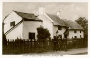
Urmston Lane, opposite the Robin Hood, 1898 / Anonymous. Urmston Lane (opposite Robin Hood Hotel) Stretford – 1898 ([s.l.], [s.d.]). Photographic postcard (monochrome). 141 x 90 mm.
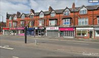
Stretford's original Robin Hood was situated around here on what is now Park Road / Google Earth Street View

