
Robin Hood (St Michael's Hill, Bristol)
[[File:|thumb|right|500px|The Robin Hood / Google Earth Street View.]]
By Henrik Thiil Nielsen, 2013-08-07. Revised by Henrik Thiil Nielsen, 2019-04-05.
The following past proprietors are known:
- 1848-49 – John Gerrish
- 1851 – James White
- 1853-55 – Thomas Davis Jarrett
- 1856 – Joseph Pittaway
- 1860-65 – Thomas Shipp
- 1866-1874 – Hannah Shipp
- 1875-79 – Thomas Ridler
- 1881-1904 – Matilda Ridler
- 1906 – Lydia Wride
- 1914-40 – James Callaway
- 1940 – Nellie Callaway
- 1944-75 – Lionel W. Hamblett.[1]
It is not known if John Gerrish (1848-49) was the first publican, but there cannot have been many in the years immediately before his tenure, for in 1841 the building was home to a carpentry and before that to a grocer's shop. However, there was also a Robin Hood pub on St Michael's Hill during the years 1752 to 82. Most likely this was located either at the same site, perhaps in the same building, or immediately north of Robin Hood Lane. See further Robin Hood and Little John (St Michael's Hill, Bristol).Template:PnItemQry
Gazetteers
- Not included in Dobson, R. B., ed.; Taylor, J., ed. Rymes of Robyn Hood: an Introduction to the English Outlaw (London, 1976), pp. 293-11.
Sources
Maps
- 25" O.S. map Gloucestershire LXXI.16 (1885; surveyed 1880-82)
- 25" O.S. map Somerset VI.2 (1896; surveyed 1881-82)
- 25" O.S. map Gloucestershire LXXI.16 (1903; rev. 1901) (georeferenced)
- 25" O.S. map Gloucestershire LXXI.16 (1903; rev. 1901)
- 25" O.S. map Somerset VI.2 (1904; rev. 1901-1902)
- 25" O.S. map Gloucestershire LXXI.16 (1918; rev. 1913)
- 6" O.S. map Gloucestershire LXXI.SE (1888; surveyed 1880-83)
- 6" O.S. map Gloucestershire LXXI.SE (1904; rev. 1901-1902)
- 6" O.S. map Somerset VI.NW (1905; rev. 1901-1902) (georeferenced)
- 6" O.S. map Somerset VI.NW (1905; rev. 1901-1902)
- 6" O.S. map Gloucestershire LXXI (1921; rev. 1912-13)
- 6" O.S. map Gloucestershire LXXI.SE (1921; rev. 1912-13)
- 6" O.S. map Somerset VI (1921; rev. 1912-13)
- 6" O.S. map Somerset VI.NW (1921; rev. 1913)
- 6" O.S. map Somerset VI.NW (1933; rev. 1930)
- 6" O.S. map Gloucestershire LXXI.SE (c. 1944; rev. 1938)
- 6" O.S. map Somerset VI.NW (c. 1945; rev. 1938)
- 6" O.S. map Gloucestershire LXXI.SE (c. 1946; rev. 1938)
- 6" O.S. map Somerset VI.NW (c. 1947; rev. 1938).
Notes
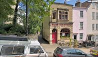
The Robin Hood / Google Earth Street View.
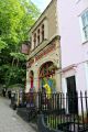
The Robin Hood pub on St Michael's Hill, Bristol. A freehouse in a Grade II listed building / Richard Hoare, 26 June, 2017; Creative Commons via Geograph.
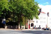
The Robin Hood, an interesting looking little pub towards the top of St Michael's Hill / Trevor Harris, 26 Sep, 2009; Creative Commons via Geograph.


