
Robin Hood (St Michael's Hill, Bristol): Difference between revisions
m (Text replacement - "Not included in {{:Dobson, Richard Barrie 1976a}}, pp. 293-19." to "Not included in {{:Dobson, Richard Barrie 1976a}}, pp. 293-11.") |
m (Text replacement - "UK Pub History" to "Pub History") |
||
| (25 intermediate revisions by 2 users not shown) | |||
| Line 1: | Line 1: | ||
__NOTOC__{{ | __NOTOC__{{PlaceNamesItemTop|Lat=51.458598|Lon=-2.599443|AdministrativeDivision=Gloucestershire|Vicinity=56 St Michael's Hill, Bristol|Type=Public house|Interest=Robin Hood name|Status=Extant|Demonym=|Riding=|GreaterLondon=|Year=1848|Aka=|Century=|Cluster1=St Michael's Hill (Bristol)|Cluster2=Bristol|Cluster3=|Image=robin-hood-st-michaels-hill-bristol-2-google-earth-street-view.jpg|Postcards=|ExtraCat1=|ExtraCat2=|ExtraCat3=|ExtraCat4=|ExtraCat5=|ExtraLink1=|ExtraLink2=|ExtraLink3=|ExtraLink4=|ExtraLink5=|ExtraLinkName1=|ExtraLinkName2=|ExtraLinkName3=|ExtraLinkName4=|ExtraLinkName5=|GeopointPrefix=|GeopointSuffix=|StatusSuffix=|DatePrefix=|DateSuffix=}} | ||
{{#display_map:{{#var:Coords}}~{{#replace:{{PAGENAME}}|'|'}}|width=34%}}<div class="pnMapLegend">The Robin Hood.</div> | {{#display_map:{{#var:Coords}}~{{#replace:{{PAGENAME}}|'|'}}|width=34%|enablefullscreen=yes}}<div class="pnMapLegend">The Robin Hood.</div> | ||
[[File:{{#var: | [[File:{{#var:Image}}|thumb|right|500px|The Robin Hood / Google Earth Street View.]]<div class="no-img"> | ||
<p id="byline">By Henrik Thiil Nielsen, 2013-08-07. Revised by {{#realname:{{REVISIONUSER}}}}, {{REVISIONYEAR}}-{{REVISIONMONTH}}-{{REVISIONDAY2}}.</p | <p id="byline">By Henrik Thiil Nielsen, 2013-08-07. Revised by {{#realname:{{REVISIONUSER}}}}, {{REVISIONYEAR}}-{{REVISIONMONTH}}-{{REVISIONDAY2}}.</p>The present Robin Hood at 56 St Michael's Hill in Bristol was in existence by 1848. Immediately north of the pub is [[Robin Hood Lane (Bristol)|Robin Hood Lane]] which connects St Michael's Hill and Horfield Road. | ||
Between them, Pub History and Bristol's Lost Pubs list the names of 12 publicans from 1848 to 1975,<ref>[http://bristolslostpubs.eu/page190.html Bristol's Lost Pubs.] Also see [https://pubwiki.co.uk/Gloucestershire/BristolR/RobinHoodMichaels.shtml Pub History: Robin Hood, 56 St Michaels Hill, Bristol, Gloucestershire.]</ref> the first being John Gerrish (1848-49). It is not known if he was the first publican, but there cannot have been many in the years immediately before his tenure, for in 1841 the building was home to a carpentry and before that to a grocer's shop. However, there was also a Robin Hood pub on St Michael's Hill during the years 1752 to 82. Most likely this was located either at the same site, perhaps in the same building, or immediately north of [[Robin Hood Lane (Bristol)|Robin Hood Lane]]. See further [[Robin Hood and Little John (St Michael's Hill, Bristol)]].{{PlaceNamesItemAllusionsAndRecords}} | |||
== Gazetteers == | == Gazetteers == | ||
* Not included in {{:Dobson, Richard Barrie 1976a}}, pp. 293-11. | * Not included in {{:Dobson, Richard Barrie 1976a}}, pp. 293-11. | ||
== Sources == | == Sources == | ||
* [http://bristolslostpubs.eu/page190.html Bristol's Lost Pubs] | * [http://bristolslostpubs.eu/page190.html Bristol's Lost Pubs] | ||
* [https:// | * [https://pubwiki.co.uk/Gloucestershire/BristolR/RobinHoodMichaels.shtml Pub History: Robin Hood, 56 St Michaels Hill, Bristol, Gloucestershire.] | ||
== Maps == | == Maps == | ||
* [https://maps.nls.uk/view/109729702#zoom=5&lat=4836&lon=10824&layers=BT 25" O.S. map ''Gloucestershire'' LXXI.16 (1885; surveyed 1880-82)] | * [https://maps.nls.uk/view/109729702#zoom=5&lat=4836&lon=10824&layers=BT 25" O.S. map ''Gloucestershire'' LXXI.16 (1885; surveyed 1880-82)] | ||
| Line 47: | Line 30: | ||
* [https://maps.nls.uk/view/101454555#zoom=6&lat=2244&lon=6921&layers=BT 6" O.S. map ''Gloucestershire'' LXXI.SE (''c.'' 1946; rev. 1938)] | * [https://maps.nls.uk/view/101454555#zoom=6&lat=2244&lon=6921&layers=BT 6" O.S. map ''Gloucestershire'' LXXI.SE (''c.'' 1946; rev. 1938)] | ||
* [https://maps.nls.uk/view/101724802#zoom=5&lat=5929&lon=7696&layers=BT 6" O.S. map ''Somerset'' VI.NW (''c.'' 1947; rev. 1938).] | * [https://maps.nls.uk/view/101724802#zoom=5&lat=5929&lon=7696&layers=BT 6" O.S. map ''Somerset'' VI.NW (''c.'' 1947; rev. 1938).] | ||
{{ | == Background == | ||
* [http://www.christmasstepsartsquarter.co.uk/business/the-robin-hood/ Christmas Steps Arts Quarter: The Robin Hood] | |||
* [http://breweryhistory.com/wiki/index.php?title=List_of_Bristol_Brewery_Georges_%26_Co_Ltd_pubs List of Bristol Brewery Georges & Co Ltd pubs: Bristol area, No. 214.] | |||
{{PlaceNamesItemAlsoSee}} | |||
== Notes == | == Notes == | ||
<references/> | <references/> | ||
</div> | |||
< | <div id="gallery"> | ||
{{ | {{ImageGalleryIntroduction}} | ||
<gallery widths="195px"> | <gallery widths="195px"> | ||
robin-hood-st-michaels-hill-bristol-2-google-earth-street-view.jpg|The Robin Hood / Google Earth Street View. | robin-hood-st-michaels-hill-bristol-2-google-earth-street-view.jpg|The Robin Hood / Google Earth Street View. | ||
geograph-5443605-by-Richard-Hoare.jpg|The Robin Hood pub on St Michael's Hill, Bristol. A freehouse in a Grade II listed building / [http://www.geograph.org.uk/photo/5443605 Richard Hoare, 26 June, 2017; Creative Commons via Geograph.] | geograph-5443605-by-Richard-Hoare.jpg|The Robin Hood pub on St Michael's Hill, Bristol. A freehouse in a Grade II listed building / [http://www.geograph.org.uk/photo/5443605 Richard Hoare, 26 June, 2017; Creative Commons, via Geograph.] | ||
geograph-1576717-by-Trevor-Harris.jpg|The Robin Hood, an interesting looking little pub towards the top of St Michael's Hill / [http://www.geograph.org.uk/photo/1576717 Trevor Harris, 26 Sep, 2009; Creative Commons via Geograph.] | geograph-1576717-by-Trevor-Harris.jpg|The Robin Hood, an interesting looking little pub towards the top of St Michael's Hill / [http://www.geograph.org.uk/photo/1576717 Trevor Harris, 26 Sep, 2009; Creative Commons, via Geograph.] | ||
</gallery> | </gallery> | ||
</div> | |||
{{PlaceNamesItemNavigation}} | |||
{{ | |||
Latest revision as of 15:31, 5 May 2022
| Locality | |
|---|---|
| Coordinate | 51.458598, -2.599443 |
| Adm. div. | Gloucestershire |
| Vicinity | 56 St Michael's Hill, Bristol |
| Type | Public house |
| Interest | Robin Hood name |
| Status | Extant |
| First Record | 1848 |

By Henrik Thiil Nielsen, 2013-08-07. Revised by Henrik Thiil Nielsen, 2022-05-05.
The present Robin Hood at 56 St Michael's Hill in Bristol was in existence by 1848. Immediately north of the pub is Robin Hood Lane which connects St Michael's Hill and Horfield Road.Between them, Pub History and Bristol's Lost Pubs list the names of 12 publicans from 1848 to 1975,[1] the first being John Gerrish (1848-49). It is not known if he was the first publican, but there cannot have been many in the years immediately before his tenure, for in 1841 the building was home to a carpentry and before that to a grocer's shop. However, there was also a Robin Hood pub on St Michael's Hill during the years 1752 to 82. Most likely this was located either at the same site, perhaps in the same building, or immediately north of Robin Hood Lane. See further Robin Hood and Little John (St Michael's Hill, Bristol).
Gazetteers
- Not included in Dobson, R. B., ed.; Taylor, J., ed. Rymes of Robyn Hood: an Introduction to the English Outlaw (London, 1976), pp. 293-11.
Sources
Maps
- 25" O.S. map Gloucestershire LXXI.16 (1885; surveyed 1880-82)
- 25" O.S. map Somerset VI.2 (1896; surveyed 1881-82)
- 25" O.S. map Gloucestershire LXXI.16 (1903; rev. 1901) (georeferenced)
- 25" O.S. map Gloucestershire LXXI.16 (1903; rev. 1901)
- 25" O.S. map Somerset VI.2 (1904; rev. 1901-1902)
- 25" O.S. map Gloucestershire LXXI.16 (1918; rev. 1913)
- 6" O.S. map Gloucestershire LXXI.SE (1888; surveyed 1880-83)
- 6" O.S. map Gloucestershire LXXI.SE (1904; rev. 1901-1902)
- 6" O.S. map Somerset VI.NW (1905; rev. 1901-1902) (georeferenced)
- 6" O.S. map Somerset VI.NW (1905; rev. 1901-1902)
- 6" O.S. map Gloucestershire LXXI (1921; rev. 1912-13)
- 6" O.S. map Gloucestershire LXXI.SE (1921; rev. 1912-13)
- 6" O.S. map Somerset VI (1921; rev. 1912-13)
- 6" O.S. map Somerset VI.NW (1921; rev. 1913)
- 6" O.S. map Somerset VI.NW (1933; rev. 1930)
- 6" O.S. map Gloucestershire LXXI.SE (c. 1944; rev. 1938)
- 6" O.S. map Somerset VI.NW (c. 1945; rev. 1938)
- 6" O.S. map Gloucestershire LXXI.SE (c. 1946; rev. 1938)
- 6" O.S. map Somerset VI.NW (c. 1947; rev. 1938).
Background
- Christmas Steps Arts Quarter: The Robin Hood
- List of Bristol Brewery Georges & Co Ltd pubs: Bristol area, No. 214.
Also see
- St Michael's Hill (Bristol) place-name cluster
- Bristol place-name cluster
- Public houses named after Robin Hood.
Notes
Image gallery
Click any image to display it in the lightbox, where you can navigate between images by clicking in the right or left side of the current image.
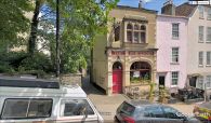
The Robin Hood / Google Earth Street View.
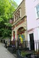
The Robin Hood pub on St Michael's Hill, Bristol. A freehouse in a Grade II listed building / Richard Hoare, 26 June, 2017; Creative Commons, via Geograph.
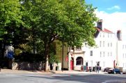
The Robin Hood, an interesting looking little pub towards the top of St Michael's Hill / Trevor Harris, 26 Sep, 2009; Creative Commons, via Geograph.

