
Robin Hood (St Albans): Difference between revisions
From International Robin Hood Bibliography
m (Text replacement - "|service=leaflet}}" to "|service=leaflet|enablefullscreen=yes}}") |
m (Text replacement - "Creative Commons via Geograph" to "Creative Commons, via Geograph") |
||
| Line 1: | Line 1: | ||
__NOTOC__{{PnItemTop|Lat=51.750567|Lon=-0.330692|AdmDiv=Hertfordshire|Vicinity=126 Victoria Street, St Albans|Type=Public house|Interest=Robin Hood name|Status=Extant|Demonym=|Riding=|GreaterLondon=|Year=1871|Aka=|Century=|Cluster1=|Cluster2=|Cluster3=|Image=geograph-2705724-by-Ian-Capper.jpg|Postcards=|ExtraCat1=|ExtraCat2=|ExtraCat3=|ExtraCat4=|ExtraCat5=|ExtraLink1=|ExtraLink2=|ExtraLink3=|ExtraLink4=|ExtraLink5=|ExtraLinkName1=|ExtraLinkName2=|ExtraLinkName3=|ExtraLinkName4=|ExtraLinkName5=|GeopointPrefix=|GeopointSuffix=|StatusSuffix=|DatePrefix=|DateSuffix=}} | __NOTOC__{{PnItemTop|Lat=51.750567|Lon=-0.330692|AdmDiv=Hertfordshire|Vicinity=126 Victoria Street, St Albans|Type=Public house|Interest=Robin Hood name|Status=Extant|Demonym=|Riding=|GreaterLondon=|Year=1871|Aka=|Century=|Cluster1=|Cluster2=|Cluster3=|Image=geograph-2705724-by-Ian-Capper.jpg|Postcards=|ExtraCat1=|ExtraCat2=|ExtraCat3=|ExtraCat4=|ExtraCat5=|ExtraLink1=|ExtraLink2=|ExtraLink3=|ExtraLink4=|ExtraLink5=|ExtraLinkName1=|ExtraLinkName2=|ExtraLinkName3=|ExtraLinkName4=|ExtraLinkName5=|GeopointPrefix=|GeopointSuffix=|StatusSuffix=|DatePrefix=|DateSuffix=}} | ||
{{#display_map:{{#var:Coords}}~{{#replace:{{PAGENAME}}|'|'}}|width=34%|service=leaflet|enablefullscreen=yes}}<div class="pnMapLegend">The Robin Hood.</div> | {{#display_map:{{#var:Coords}}~{{#replace:{{PAGENAME}}|'|'}}|width=34%|service=leaflet|enablefullscreen=yes}}<div class="pnMapLegend">The Robin Hood.</div> | ||
[[File:{{#var:Pnimage}}|thumb|right|500px|The Robin Hood [http://www.geograph.org.uk/photo/2705724 Ian Capper, 4 Oct. 2011, Creative Commons via Geograph.]]] | [[File:{{#var:Pnimage}}|thumb|right|500px|The Robin Hood [http://www.geograph.org.uk/photo/2705724 Ian Capper, 4 Oct. 2011, Creative Commons, via Geograph.]]] | ||
<p id="byline">By Henrik Thiil Nielsen, 2013-08-07. Revised by {{#realname:{{REVISIONUSER}}}}, {{REVISIONYEAR}}-{{REVISIONMONTH}}-{{REVISIONDAY2}}.</p> | <p id="byline">By Henrik Thiil Nielsen, 2013-08-07. Revised by {{#realname:{{REVISIONUSER}}}}, {{REVISIONYEAR}}-{{REVISIONMONTH}}-{{REVISIONDAY2}}.</p> | ||
<div class="no-img"> | <div class="no-img"> | ||
| Line 31: | Line 31: | ||
{{ImgGalleryIntro}} | {{ImgGalleryIntro}} | ||
<gallery widths="195px"> | <gallery widths="195px"> | ||
geograph-2705724-by-Ian-Capper.jpg|The Robin Hood [http://www.geograph.org.uk/photo/2705724 Ian Capper, 4 Oct. 2011, Creative Commons via Geograph.] | geograph-2705724-by-Ian-Capper.jpg|The Robin Hood [http://www.geograph.org.uk/photo/2705724 Ian Capper, 4 Oct. 2011, Creative Commons, via Geograph.] | ||
geograph-1063912-by-Martin-Addison.jpg|The Robin Hood / [http://www.geograph.org.uk/photo/1063912 Martin Addison, Dec. 1975, Creative Commons via Geograph.] | geograph-1063912-by-Martin-Addison.jpg|The Robin Hood / [http://www.geograph.org.uk/photo/1063912 Martin Addison, Dec. 1975, Creative Commons, via Geograph.] | ||
google-earth-street-view-robin-hood-st-albans.jpg|The Robin Hood / Google Earth Street View. | google-earth-street-view-robin-hood-st-albans.jpg|The Robin Hood / Google Earth Street View. | ||
</gallery> | </gallery> | ||
{{PnItemNav}} | {{PnItemNav}} | ||
Revision as of 11:23, 30 May 2019
The Robin Hood.
[[File:|thumb|right|500px|The Robin Hood Ian Capper, 4 Oct. 2011, Creative Commons, via Geograph.]]
By Henrik Thiil Nielsen, 2013-08-07. Revised by Henrik Thiil Nielsen, 2019-05-30.
The Robin Hood on Victoria Street in St Albans is first documented through census records in 1871. UK Pub History has information on publicans etc. up to 1937.[1]Template:PnItemQry
Gazetteers
- Not included in Dobson, R. B., ed.; Taylor, J., ed. Rymes of Robyn Hood: an Introduction to the English Outlaw (London, 1976), pp. 293-311.
Sources
Maps
- 25" O.S. map Hertfordshire XXXIV.12 (1880; surveyed 1872)
- 25" O.S. map Hertfordshire XXXIV.12 (1898; rev. 1897) (georeferenced)
- 25" O.S. map Hertfordshire XXXIV.12 (1898; rev. 1897)
- 25" O.S. map Hertfordshire XXXIV.12 (1924; rev. 1922)
- 25" O.S. map Hertfordshire XXXIV.12 (1940; rev. 1937)
- 6" O.S. map Hertfordshire XXXIV (1883; surveyed 1872-78)
- 6" O.S. map Hertfordshire XXXIV.SE (1899; rev. 1897) (georeferenced)
- 6" O.S. map Hertfordshire XXXIV.SE (1899; rev. 1897)
- 6" O.S. map Hertfordshire XXXIV.SE (1925; rev. 1923)
- 6" O.S. map Hertfordshire XXXIV.SE (1951; rev. 1938-39).
Notes
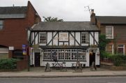
The Robin Hood Ian Capper, 4 Oct. 2011, Creative Commons, via Geograph.
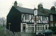
The Robin Hood / Martin Addison, Dec. 1975, Creative Commons, via Geograph.
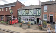
The Robin Hood / Google Earth Street View.


