
Robin Hood (St Albans): Difference between revisions
From International Robin Hood Bibliography
mNo edit summary |
m (Text replacement - "UK Pub History" to "Pub History") |
||
| (20 intermediate revisions by 2 users not shown) | |||
| Line 1: | Line 1: | ||
__NOTOC__{{ | __NOTOC__{{PlaceNamesItemTop|Lat=51.750567|Lon=-0.330692|AdministrativeDivision=Hertfordshire|Vicinity=126 Victoria Street, St Albans|Type=Public house|Interest=Robin Hood name|Status=Extant|Demonym=|Riding=|GreaterLondon=|Year=1871|Aka=|Century=|Cluster1=|Cluster2=|Cluster3=|Image=geograph-2705724-by-Ian-Capper.jpg|Postcards=|ExtraCat1=|ExtraCat2=|ExtraCat3=|ExtraCat4=|ExtraCat5=|ExtraLink1=|ExtraLink2=|ExtraLink3=|ExtraLink4=|ExtraLink5=|ExtraLinkName1=|ExtraLinkName2=|ExtraLinkName3=|ExtraLinkName4=|ExtraLinkName5=|GeopointPrefix=|GeopointSuffix=|StatusSuffix=|DatePrefix=|DateSuffix=}} | ||
{{#display_map:{{#var:Coords}}~{{#replace:{{PAGENAME}}|'|'}}|width=34%}}<div class="pnMapLegend">The Robin Hood.</div> | {{#display_map:{{#var:Coords}}~{{#replace:{{PAGENAME}}|'|'}}|width=34%|enablefullscreen=yes}}<div class="pnMapLegend">The Robin Hood.</div> | ||
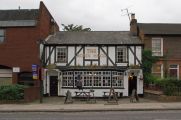
[[File:{{#var: | [[File:{{#var:Image}}|thumb|right|500px|The Robin Hood [http://www.geograph.org.uk/photo/2705724 Ian Capper, 4 Oct. 2011, Creative Commons, via Geograph.]]]<div class="no-img"> | ||
<p id="byline">By Henrik Thiil Nielsen, 2013-08-07. Revised by {{#realname:{{REVISIONUSER}}}}, {{REVISIONYEAR}}-{{REVISIONMONTH}}-{{REVISIONDAY2}}.</p> | <p id="byline">By Henrik Thiil Nielsen, 2013-08-07. Revised by {{#realname:{{REVISIONUSER}}}}, {{REVISIONYEAR}}-{{REVISIONMONTH}}-{{REVISIONDAY2}}.</p> | ||
The Robin Hood on Victoria Street in St Albans is first documented through census records in 1871. Pub History has information on publicans etc. up to 1937.<ref>[https://pubwiki.co.uk/HertsPubs/StAlbans/RobinHood.shtml Pub History: Robin Hood, 126 Victoria Road, St Albans, Hertfordshire.]</ref>{{PlaceNamesItemAllusionsAndRecords}} | |||
The Robin Hood on Victoria Street in St Albans is first documented through census records in 1871. | |||
== Gazetteers == | == Gazetteers == | ||
| Line 10: | Line 9: | ||
== Sources == | == Sources == | ||
* [https:// | * [https://pubwiki.co.uk/HertsPubs/StAlbans/RobinHood.shtml Pub History: Robin Hood, 126 Victoria Road, St Albans, Hertfordshire.] | ||
== Maps == | == Maps == | ||
| Line 23: | Line 22: | ||
* [https://maps.nls.uk/view/101579619#zoom=6&lat=5651&lon=5012&layers=BT 6" O.S. map ''Hertfordshire'' XXXIV.SE (1925; rev. 1923)] | * [https://maps.nls.uk/view/101579619#zoom=6&lat=5651&lon=5012&layers=BT 6" O.S. map ''Hertfordshire'' XXXIV.SE (1925; rev. 1923)] | ||
* [https://maps.nls.uk/view/101579616#zoom=6&lat=5642&lon=4897&layers=BT 6" O.S. map ''Hertfordshire'' XXXIV.SE (1951; rev. 1938-39).] | * [https://maps.nls.uk/view/101579616#zoom=6&lat=5642&lon=4897&layers=BT 6" O.S. map ''Hertfordshire'' XXXIV.SE (1951; rev. 1938-39).] | ||
{{ | {{PlaceNamesItemAlsoSee}} | ||
== Notes == | == Notes == | ||
<references/> | <references/> | ||
</div> | |||
< | <div id="gallery"> | ||
{{ | {{ImageGalleryIntroduction}} | ||
<gallery widths="195px"> | <gallery widths="195px"> | ||
geograph-2705724-by-Ian-Capper.jpg|The Robin Hood [http://www.geograph.org.uk/photo/2705724 Ian Capper, 4 Oct. 2011, Creative Commons via Geograph.] | geograph-2705724-by-Ian-Capper.jpg|The Robin Hood [http://www.geograph.org.uk/photo/2705724 Ian Capper, 4 Oct. 2011, Creative Commons, via Geograph.] | ||
geograph-1063912-by-Martin-Addison.jpg|The Robin Hood / [http://www.geograph.org.uk/photo/1063912 Martin Addison, Dec. 1975, Creative Commons via Geograph.] | geograph-1063912-by-Martin-Addison.jpg|The Robin Hood / [http://www.geograph.org.uk/photo/1063912 Martin Addison, Dec. 1975, Creative Commons, via Geograph.] | ||
google-earth-street-view-robin-hood-st-albans.jpg|The Robin Hood / Google Earth Street View. | google-earth-street-view-robin-hood-st-albans.jpg|The Robin Hood / Google Earth Street View. | ||
</gallery> | </gallery> | ||
</div> | |||
{{ | {{PlaceNamesItemNavigation}} | ||
Latest revision as of 15:31, 5 May 2022
| Locality | |
|---|---|
| Coordinate | 51.750567, -0.330692 |
| Adm. div. | Hertfordshire |
| Vicinity | 126 Victoria Street, St Albans |
| Type | Public house |
| Interest | Robin Hood name |
| Status | Extant |
| First Record | 1871 |
The Robin Hood.

The Robin Hood Ian Capper, 4 Oct. 2011, Creative Commons, via Geograph.
By Henrik Thiil Nielsen, 2013-08-07. Revised by Henrik Thiil Nielsen, 2022-05-05.
The Robin Hood on Victoria Street in St Albans is first documented through census records in 1871. Pub History has information on publicans etc. up to 1937.[1]
Gazetteers
- Not included in Dobson, R. B., ed.; Taylor, J., ed. Rymes of Robyn Hood: an Introduction to the English Outlaw (London, 1976), pp. 293-311.
Sources
Maps
- 25" O.S. map Hertfordshire XXXIV.12 (1880; surveyed 1872)
- 25" O.S. map Hertfordshire XXXIV.12 (1898; rev. 1897) (georeferenced)
- 25" O.S. map Hertfordshire XXXIV.12 (1898; rev. 1897)
- 25" O.S. map Hertfordshire XXXIV.12 (1924; rev. 1922)
- 25" O.S. map Hertfordshire XXXIV.12 (1940; rev. 1937)
- 6" O.S. map Hertfordshire XXXIV (1883; surveyed 1872-78)
- 6" O.S. map Hertfordshire XXXIV.SE (1899; rev. 1897) (georeferenced)
- 6" O.S. map Hertfordshire XXXIV.SE (1899; rev. 1897)
- 6" O.S. map Hertfordshire XXXIV.SE (1925; rev. 1923)
- 6" O.S. map Hertfordshire XXXIV.SE (1951; rev. 1938-39).
Also see
Notes
Image gallery
Click any image to display it in the lightbox, where you can navigate between images by clicking in the right or left side of the current image.
The Robin Hood Ian Capper, 4 Oct. 2011, Creative Commons, via Geograph.
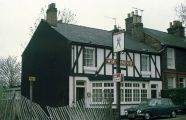
The Robin Hood / Martin Addison, Dec. 1975, Creative Commons, via Geograph.
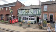
The Robin Hood / Google Earth Street View.

