
Robin Hood (Spalding): Difference between revisions
mNo edit summary |
m (Text replacement - "ImgGalleryIntro" to "ImageGalleryIntroduction") |
||
| (15 intermediate revisions by 2 users not shown) | |||
| Line 1: | Line 1: | ||
__NOTOC__{{ | __NOTOC__{{PlaceNamesItemTop|Lat=52.784295|Lon=-0.167869|AdministrativeDivision=Lincolnshire|Vicinity=1 Bourne Road, Spalding|Type=Public house|Interest=Robin Hood name|Status=Extant|Demonym=|Riding=|GreaterLondon=|Year=1888|Aka=|Century=|Cluster1=|Cluster2=|Cluster3=|Image=Geograph-2574223-by-Ian-S.jpg|Postcards=|ExtraCat1=|ExtraCat2=|ExtraCat3=|ExtraCat4=|ExtraCat5=|ExtraLink1=|ExtraLink2=|ExtraLink3=|ExtraLink4=|ExtraLink5=|ExtraLinkName1=|ExtraLinkName2=|ExtraLinkName3=|ExtraLinkName4=|ExtraLinkName5=|GeopointPrefix=|GeopointSuffix=|StatusSuffix=|DatePrefix=|DateSuffix=}} | ||
{{#display_map:{{#var:Coords}}~{{#replace:{{PAGENAME}}|'|'}}|width=34% | {{#display_map:{{#var:Coords}}~{{#replace:{{PAGENAME}}|'|'}}|width=34%|enablefullscreen=yes}}<div class="pnMapLegend">The Robin Hood.</div> | ||
[[File:robin-hood-bourne-road-spalding-google-earth.jpg|thumb|right|500px|The Robin Hood, 1 Bourne Road, Spalding / Google Earth Street View.]] | [[File:robin-hood-bourne-road-spalding-google-earth.jpg|thumb|right|500px|The Robin Hood, 1 Bourne Road, Spalding / Google Earth Street View.]]<div class="no-img"> | ||
<p id="byline">By Henrik Thiil Nielsen, 2013- | <p id="byline">By Henrik Thiil Nielsen, 2013-06-11. Revised by {{#realname:{{REVISIONUSER}}}}, {{REVISIONYEAR}}-{{REVISIONMONTH}}-{{REVISIONDAY2}}.</p> | ||
The first record I have found of the Robin Hood Pub in Spalding is the 6" O.S. map of the area published in 1888. It is indicated there as "Robin Hood Inn".<ref>[http://maps.nls.uk/view/101591351#zoom=5&lat=5612&lon=3674&layers=BT Lincolnshire CXLII.NW (1888; surveyed 1887).]</ref> On three maps published 1906-''c.'' 1931, but based on surveying done in 1903, it is indicated simply as "Inn". On subsequent maps this indication is lacking (see Maps section below), but one gets the impression from the regulars quoted in a local newspaper that the Robin Hood was in business throughout. Sadly as of November 2015 the pub's existence was threatened.<ref>[http://www.spaldingtoday.co.uk/news/hope-as-community-battles-to-save-another-pub-in-spalding-1-7082749 Spalding Today: Hope as community battles to save another pub in Spalding (24 Nov. 2015).]</ref> | The first record I have found of the Robin Hood Pub in Spalding is the 6" O.S. map of the area published in 1888. It is indicated there as "Robin Hood Inn".<ref>[http://maps.nls.uk/view/101591351#zoom=5&lat=5612&lon=3674&layers=BT Lincolnshire CXLII.NW (1888; surveyed 1887).]</ref> On three maps published 1906-''c.'' 1931, but based on surveying done in 1903, it is indicated simply as "Inn". On subsequent maps this indication is lacking (see Maps section below), but one gets the impression from the regulars quoted in a local newspaper that the Robin Hood was in business throughout. Sadly as of November 2015 the pub's existence was threatened.<ref>[http://www.spaldingtoday.co.uk/news/hope-as-community-battles-to-save-another-pub-in-spalding-1-7082749 Spalding Today: Hope as community battles to save another pub in Spalding (24 Nov. 2015).]</ref> | ||
{{ | {{PlaceNamesItemAllusionsAndRecords}} | ||
== Gazetteers == | == Gazetteers == | ||
* Not included in {{:Dobson, Richard Barrie 1976a}}, pp. 293-311. | * Not included in {{:Dobson, Richard Barrie 1976a}}, pp. 293-311. | ||
| Line 20: | Line 19: | ||
== Background == | == Background == | ||
* [http://www.spaldingtoday.co.uk/news/hope-as-community-battles-to-save-another-pub-in-spalding-1-7082749 Spalding Guardian: Hope as community battles to save another pub in Spalding (24 Nov. 2015).] | * [http://www.spaldingtoday.co.uk/news/hope-as-community-battles-to-save-another-pub-in-spalding-1-7082749 Spalding Guardian: Hope as community battles to save another pub in Spalding (24 Nov. 2015).] | ||
{{ | {{PlaceNamesItemAlsoSee}} | ||
== Notes == | == Notes == | ||
<references/> | <references/> | ||
</div> | |||
< | <div id="gallery"> | ||
{{ | {{ImageGalleryIntroduction}} | ||
<gallery widths="195px"> | <gallery widths="195px"> | ||
File:robin-hood-bourne-road-spalding-google-earth.jpg|The Robin Hood, 1 Bourne Road, Spalding / Google Earth Street View. | File:robin-hood-bourne-road-spalding-google-earth.jpg|The Robin Hood, 1 Bourne Road, Spalding / Google Earth Street View. | ||
| Line 32: | Line 32: | ||
File:3118172_bb31a41a.jpg|thumb|right|500px|The Robin Hood / [http://www.geograph.org.uk/photo/3118172 J. Thomas, 6 Sep. 2012, Creative Commons, via Geograph.] | File:3118172_bb31a41a.jpg|thumb|right|500px|The Robin Hood / [http://www.geograph.org.uk/photo/3118172 J. Thomas, 6 Sep. 2012, Creative Commons, via Geograph.] | ||
</gallery> | </gallery> | ||
</div> | |||
{{ | {{PlaceNamesItemNavigation}} | ||
Latest revision as of 13:53, 7 January 2021
| Locality | |
|---|---|
| Coordinate | 52.784295, -0.167869 |
| Adm. div. | Lincolnshire |
| Vicinity | 1 Bourne Road, Spalding |
| Type | Public house |
| Interest | Robin Hood name |
| Status | Extant |
| First Record | 1888 |

By Henrik Thiil Nielsen, 2013-06-11. Revised by Henrik Thiil Nielsen, 2021-01-07.
The first record I have found of the Robin Hood Pub in Spalding is the 6" O.S. map of the area published in 1888. It is indicated there as "Robin Hood Inn".[1] On three maps published 1906-c. 1931, but based on surveying done in 1903, it is indicated simply as "Inn". On subsequent maps this indication is lacking (see Maps section below), but one gets the impression from the regulars quoted in a local newspaper that the Robin Hood was in business throughout. Sadly as of November 2015 the pub's existence was threatened.[2]
Gazetteers
- Not included in Dobson, R. B., ed.; Taylor, J., ed. Rymes of Robyn Hood: an Introduction to the English Outlaw (London, 1976), pp. 293-311.
Maps
- 6" O.S. map Lincolnshire CXLII.NW (1888; surveyed 1887)
- 6" O.S. map Lincolnshire CXLII.NW (1906; rev. 1903)
- 6" O.S. map Lincolnshire CXLII.NW (1906; rev. 1903) (georeferenced)
- 6" O.S. map Lincolnshire CXLII.NW (c. 1931; rev. 1903)
- 6" O.S. map Lincolnshire CXLII.NW (1932; rev. 1929)
- 6" O.S. map Lincolnshire CXLII.NW (c. 1948; rev. 1938)
- 6" O.S. map Lincolnshire CXLII.NW (1952; rev. 1950).
Background
Also see
Notes
Image gallery
Click any image to display it in the lightbox, where you can navigate between images by clicking in the right or left side of the current image.
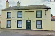
The Robin Hood, 1 Bourne Road, Spalding / Google Earth Street View.
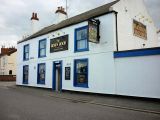
The Robin Hood / Ian S,, 28 Aug. 2011, Creative Commons, via Geograph.
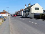
The Robin Hood / Matt Fascione, 17 Aug. 2014, Creative Commons, via Geograph.
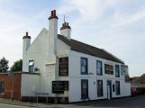
The Robin Hood / J. Thomas, 6 Sep. 2012, Creative Commons, via Geograph.


