
Robin Hood (Norton): Difference between revisions
m (Henryfunk moved page Robin Hood (Norton le Moors) to Robin Hood (Norton) without leaving a redirect) |
m (Text replacement - "No Copy in NLS" to "No copy in NLS") |
||
| (14 intermediate revisions by the same user not shown) | |||
| Line 1: | Line 1: | ||
__NOTOC__{{ | __NOTOC__{{PlaceNamesItemTop|Lat=53.058172 | ||
|Lon=-2.163914| | |Lon=-2.163914|AdministrativeDivision=Staffordshire|Vicinity=316 Ford Green Road, Norton, Stoke-on-Trent|Type=Public house|Interest=Robin Hood name| | ||
Status=Extant|Demonym=|Riding=|GreaterLondon=|Year=1845|Aka=|Century=|Cluster1=|Cluster2=|Cluster3=|Image=geograph-4048229-by-David-Weston.jpg|Postcards=|ExtraCat1=|ExtraCat2=|ExtraCat3=|ExtraCat4=|ExtraCat5=|ExtraLink1=|ExtraLink2=|ExtraLink3=|ExtraLink4=|ExtraLink5=|ExtraLinkName1=|ExtraLinkName2=|ExtraLinkName3=|ExtraLinkName4=|ExtraLinkName5=|GeopointPrefix=|GeopointSuffix=|VicinitySuffix=|StatusSuffix=|DatePrefix=|DateSuffix=}} | Status=Extant|Demonym=|Riding=|GreaterLondon=|Year=1845|Aka=|Century=|Cluster1=|Cluster2=|Cluster3=|Image=geograph-4048229-by-David-Weston.jpg|Postcards=|ExtraCat1=|ExtraCat2=|ExtraCat3=|ExtraCat4=|ExtraCat5=|ExtraLink1=|ExtraLink2=|ExtraLink3=|ExtraLink4=|ExtraLink5=|ExtraLinkName1=|ExtraLinkName2=|ExtraLinkName3=|ExtraLinkName4=|ExtraLinkName5=|GeopointPrefix=|GeopointSuffix=|VicinitySuffix=|StatusSuffix=|DatePrefix=|DateSuffix=}} | ||
{{#display_map:{{#var:Coords}}~{{#replace:{{PAGENAME}}|'|'}}|width=34%}}<div class="pnMapLegend">The Robin Hood, Norton | {{#display_map:{{#var:Coords}}~{{#replace:{{PAGENAME}}|'|'}}|width=34%|fullscreen=yes}}<div class="pnMapLegend">The Robin Hood, Norton.</div> | ||
[[File:{{#var: | [[File:{{#var:Image}}|thumb|right|500px|The Robin Hood, Norton: Ford Green Road (the B5051) on the right, Spragg House Lane in front / [https://m.geograph.org.uk/photo/4048229 David Weston, 29 June. 2014, Creative Commons, via Geograph.]]] | ||
<div class="no-img"><p id="byline">By Henrik Thiil Nielsen, 2020-11-01. Revised by {{#realname:{{REVISIONUSER}}}}, {{REVISIONYEAR}}-{{REVISIONMONTH}}-{{REVISIONDAY2}}.</p> | <div class="no-img"><p id="byline">By Henrik Thiil Nielsen, 2020-11-01. Revised by {{#realname:{{REVISIONUSER}}}}, {{REVISIONYEAR}}-{{REVISIONMONTH}}-{{REVISIONDAY2}}.</p> | ||
The still thriving Robin Hood pub on the corner of Ford Green Road and Spragg House Lane in Norton | The still thriving Robin Hood pub on the corner of Ford Green Road and Spragg House Lane in Norton, Stoke-on-Trent, was in existence by 1845. | ||
In that year a newspaper reported that two colliers had misbehaved in the pub, being 'disguised in drink'.<ref>[http://www.pubhistorysociety.co.uk/stoke.html Pub History Society: PHS Book Review: Stoke-on-Trent Pubs by Mervyn Edwards, Amberley, 96 pages, 2014.]</ref> | In that year a newspaper reported that two colliers had misbehaved in the pub, being 'disguised in drink'.<ref>[http://www.pubhistorysociety.co.uk/stoke.html Pub History Society: PHS Book Review: Stoke-on-Trent Pubs by Mervyn Edwards, Amberley, 96 pages, 2014.]</ref> The pub is included in all the early O.S. maps listed below. | ||
{{ | {{PlaceNamesItemAllusionsAndRecords}} | ||
== Gazetteers == | == Gazetteers == | ||
* Not included in {{:Dobson, Richard Barrie 1976a}}, pp. 293-311. | * Not included in {{:Dobson, Richard Barrie 1976a}}, pp. 293-311. | ||
| Line 16: | Line 16: | ||
== Maps == | == Maps == | ||
* | * [https://maps.nls.uk/view/115470528#zoom=6&lat=7952&lon=3276&layers=BT 25" O.S. map ''Staffordshire'' XII.6 (1881; rev. 1876–77)] | ||
* [https://maps.nls.uk/view/115470531#zoom=5&lat=8608&lon=3241&layers=BT 25" O.S. map ''Staffordshire'' XII.6 (1899; rev. 1898)] | |||
* [https://maps.nls.uk/geo/explore/#zoom=17&lat=53.05820&lon=-2.16491&layers=168&b=5 25" O.S. map ''Staffordshire'' XII.6 (1899; rev. 1898)] (georeferenced) | |||
* 25" O.S. map ''Staffordshire'' XII.6 (''c.'' 1925; rev. ''c.'' 1922). No copy in NLS | |||
* [https://maps.nls.uk/view/115470534#zoom=7&lat=8141&lon=3497&layers=BT 25" O.S. map ''Staffordshire'' XII.6 (1940; rev. 1937)] | |||
* [https://maps.nls.uk/geo/explore/#zoom=16&lat=53.05817&lon=-2.16535&layers=6&b=5 6" O.S. map ''Staffordshire'' XII.NW (1900; rev. 1898)] (georeferenced) | |||
* [https://maps.nls.uk/view/101595875#zoom=7&lat=2965&lon=5451&layers=BT 6" O.S. map ''Staffordshire'' XII.NW (1889; surveyed 1878)] | |||
* [https://maps.nls.uk/view/101595872#zoom=7&lat=2811&lon=5116&layers=BT 6" O.S. map ''Staffordshire'' XII.NW (1900; rev. 1898)] | |||
* [https://maps.nls.uk/view/101595869#zoom=7&lat=2972&lon=5168&layers=BT 6" O.S. map ''Staffordshire'' XII.NW (1925; rev. 1922)] | |||
* [https://maps.nls.uk/view/101595866#zoom=7&lat=3097&lon=5343&layers=BT 6" O.S. map ''Staffordshire'' XII.NW (''c.'' 1947; rev. 1938)] | |||
* [https://maps.nls.uk/view/101595863#zoom=7&lat=3032&lon=5231&layers=BT 6" O.S. map ''Staffordshire'' XII.NW (1951; rev. 1937–45).] | |||
<!--== Discussion == | <!--== Discussion == | ||
* | * --> | ||
== Background == | == Background == | ||
* [https:// | * [https://www.facebook.com/RobinHoodNorton Facebook: The Robin Hood.] | ||
<!--== Brief mention == | <!--== Brief mention == | ||
* --> | * --> | ||
{{ | {{PlaceNamesItemAlsoSee}} | ||
== Notes == | == Notes == | ||
| Line 30: | Line 40: | ||
</div> | </div> | ||
{{ | {{ImageGalleryIntroduction}} | ||
<gallery widths="195px"> | <gallery widths="195px"> | ||
geograph-4048229-by-David-Weston.jpg|The Robin Hood, Norton | geograph-4048229-by-David-Weston.jpg|The Robin Hood, Norton: Ford Green Road (the B5051) on the right, Spragg House Lane in front / [https://m.geograph.org.uk/photo/4048229 David Weston, 29 June. 2014, Creative Commons, via Geograph.] | ||
robin-hood-norton | robin-hood-norton-google-earth-street-view.1.jpg|The Robin Hood seen from Ford Green Road / Google Earth Street View. | ||
robin-hood-norton | robin-hood-norton-google-earth-street-view.2.jpg|The Robin Hood seen from Spragg House Lane / Google Earth Street View. | ||
</gallery> | </gallery> | ||
{{ | {{PlaceNamesItemNavigation}} | ||
Latest revision as of 01:09, 13 February 2021
| Locality | |
|---|---|
| Coordinate | 53.058172, -2.163914 |
| Adm. div. | Staffordshire |
| Vicinity | 316 Ford Green Road, Norton, Stoke-on-Trent |
| Type | Public house |
| Interest | Robin Hood name |
| Status | Extant |
| First Record | 1845 |

By Henrik Thiil Nielsen, 2020-11-01. Revised by Henrik Thiil Nielsen, 2021-02-13.
The still thriving Robin Hood pub on the corner of Ford Green Road and Spragg House Lane in Norton, Stoke-on-Trent, was in existence by 1845.
In that year a newspaper reported that two colliers had misbehaved in the pub, being 'disguised in drink'.[1] The pub is included in all the early O.S. maps listed below.
Gazetteers
- Not included in Dobson, R. B., ed.; Taylor, J., ed. Rymes of Robyn Hood: an Introduction to the English Outlaw (London, 1976), pp. 293-311.
Sources
Maps
- 25" O.S. map Staffordshire XII.6 (1881; rev. 1876–77)
- 25" O.S. map Staffordshire XII.6 (1899; rev. 1898)
- 25" O.S. map Staffordshire XII.6 (1899; rev. 1898) (georeferenced)
- 25" O.S. map Staffordshire XII.6 (c. 1925; rev. c. 1922). No copy in NLS
- 25" O.S. map Staffordshire XII.6 (1940; rev. 1937)
- 6" O.S. map Staffordshire XII.NW (1900; rev. 1898) (georeferenced)
- 6" O.S. map Staffordshire XII.NW (1889; surveyed 1878)
- 6" O.S. map Staffordshire XII.NW (1900; rev. 1898)
- 6" O.S. map Staffordshire XII.NW (1925; rev. 1922)
- 6" O.S. map Staffordshire XII.NW (c. 1947; rev. 1938)
- 6" O.S. map Staffordshire XII.NW (1951; rev. 1937–45).
Background
Also see
Notes
Image gallery
Click any image to display it in the lightbox, where you can navigate between images by clicking in the right or left side of the current image.

The Robin Hood, Norton: Ford Green Road (the B5051) on the right, Spragg House Lane in front / David Weston, 29 June. 2014, Creative Commons, via Geograph.
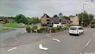
The Robin Hood seen from Ford Green Road / Google Earth Street View.

The Robin Hood seen from Spragg House Lane / Google Earth Street View.

