
Robin Hood (Norton): Difference between revisions
mNo edit summary |
mNo edit summary |
||
| Line 28: | Line 28: | ||
* [https://maps.nls.uk/view/101595863#zoom=7&lat=3032&lon=5231&layers=BT 6" O.S. map ''Staffordshire'' XII.NW (1951; rev. 1937–45).] | * [https://maps.nls.uk/view/101595863#zoom=7&lat=3032&lon=5231&layers=BT 6" O.S. map ''Staffordshire'' XII.NW (1951; rev. 1937–45).] | ||
<!--== Discussion == | <!--== Discussion == | ||
* | * --> | ||
== Background == | == Background == | ||
* | * [https://www.facebook.com/RobinHoodNorton Facebook: The Robin Hood.] | ||
<!--== Brief mention == | <!--== Brief mention == | ||
* --> | * --> | ||
Revision as of 19:59, 1 November 2020
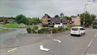
[[File:|thumb|right|500px|The Robin Hood, Norton: Ford Green Road (the B5051) on the right, Spragg House Lane in front / David Weston, 29 June. 2014, Creative Commons, via Geograph.]]
By Henrik Thiil Nielsen, 2020-11-01. Revised by Henrik Thiil Nielsen, 2020-11-01.
The still thriving Robin Hood pub on the corner of Ford Green Road and Spragg House Lane in Norton, Stoke-on-Trent, was in existence by 1845.
In that year a newspaper reported that two colliers had misbehaved in the pub, being 'disguised in drink'.[1] The pub is included in all the early O.S. maps listed below. Template:PnItemQry
Gazetteers
- Not included in Dobson, R. B., ed.; Taylor, J., ed. Rymes of Robyn Hood: an Introduction to the English Outlaw (London, 1976), pp. 293-311.
Sources
Maps
- 25" O.S. map Staffordshire XII.6 (1881; rev. 1876–77)
- 25" O.S. map Staffordshire XII.6 (1899; rev. 1898)
- 25" O.S. map Staffordshire XII.6 (1899; rev. 1898) (georeferenced)
- 25" O.S. map Staffordshire XII.6 (c. 1925; rev. c. 1922). No Copy in NLS
- 25" O.S. map Staffordshire XII.6 (1940; rev. 1937)
- 6" O.S. map Staffordshire XII.NW (1900; rev. 1898) (georeferenced)
- 6" O.S. map Staffordshire XII.NW (1889; surveyed 1878)
- 6" O.S. map Staffordshire XII.NW (1900; rev. 1898)
- 6" O.S. map Staffordshire XII.NW (1925; rev. 1922)
- 6" O.S. map Staffordshire XII.NW (c. 1947; rev. 1938)
- 6" O.S. map Staffordshire XII.NW (1951; rev. 1937–45).
Background
Notes

The Robin Hood, Norton: Ford Green Road (the B5051) on the right, Spragg House Lane in front / David Weston, 29 June. 2014, Creative Commons, via Geograph.
The Robin Hood seen from Ford Green Road / Google Earth Street View.

The Robin Hood seen from Spragg House Lane / Google Earth Street View.


