
Robin Hood (Newton Heath, Manchester): Difference between revisions
m (→MS Sources) |
m (Text replacement - "No Copy in NLS" to "No copy in NLS") |
||
| (20 intermediate revisions by 2 users not shown) | |||
| Line 1: | Line 1: | ||
__NOTOC__{{ | __NOTOC__{{PlaceNamesItemTop|Lat=53.499106|Lon=-2.172579|AdministrativeDivision=Lancashire|Vicinity=237 Droylsden Road, Newton Heath, Manchester|Type=Public house|Interest=Robin Hood name| | ||
Status=Defunct|Demonym=|Riding=|GreaterLondon=|Year=1861|Aka=Robin Hood Beerhouse|Century=|Cluster1=Manchester|Cluster2=|Cluster3=|Image=geograph-1798380-by-David-Dixon.jpg|Postcards=|ExtraCat1=|ExtraCat2=|ExtraCat3=|ExtraCat4=|ExtraCat5=|ExtraLink1=|ExtraLink2=|ExtraLink3=|ExtraLink4=|ExtraLink5=|ExtraLinkName1=|ExtraLinkName2=|ExtraLinkName3=|ExtraLinkName4=|ExtraLinkName5=|GeopointPrefix=|GeopointSuffix=|VicinitySuffix=|StatusSuffix=|DatePrefix=|DateSuffix=}} | Status=Defunct|Demonym=|Riding=|GreaterLondon=|Year=1861|Aka=Robin Hood Beerhouse|Century=|Cluster1=Manchester|Cluster2=|Cluster3=|Image=geograph-1798380-by-David-Dixon.jpg|Postcards=|ExtraCat1=|ExtraCat2=|ExtraCat3=|ExtraCat4=|ExtraCat5=|ExtraLink1=|ExtraLink2=|ExtraLink3=|ExtraLink4=|ExtraLink5=|ExtraLinkName1=|ExtraLinkName2=|ExtraLinkName3=|ExtraLinkName4=|ExtraLinkName5=|GeopointPrefix=|GeopointSuffix=|VicinitySuffix=|StatusSuffix=|DatePrefix=|DateSuffix=}} | ||
{{#display_map:{{#var:Coords}}~{{#replace:{{PAGENAME}}|'|'}}|width=34%}}<div class="pnMapLegend">The former Robin Hood.</div> | {{#display_map:{{#var:Coords}}~{{#replace:{{PAGENAME}}|'|'}}|width=34%|enablefullscreen=yes}}<div class="pnMapLegend">The former Robin Hood.</div> | ||
[[File:{{#var: | [[File:{{#var:Image}}|thumb|right|500px|Robin Hood Inn at the corner of Averill Street and Droylsden Road / [https://www.geograph.org.uk/photo/1798380 David Dixon, 9 Apr. 2010, Creative Commons, via Geograph.]]]<div class="no-img"> | ||
<p id="byline">By Henrik Thiil Nielsen, 2019-03-05. Revised by {{#realname:{{REVISIONUSER}}}}, {{REVISIONYEAR}}-{{REVISIONMONTH}}-{{REVISIONDAY2}}.</p | <p id="byline">By Henrik Thiil Nielsen, 2019-03-05. Revised by {{#realname:{{REVISIONUSER}}}}, {{REVISIONYEAR}}-{{REVISIONMONTH}}-{{REVISIONDAY2}}.</p> | ||
The Robin Hood on 237 Droylsden Road, Newton Heath, Manchester, was in existence by 1861. It closed ''c.'' 2010. | The Robin Hood on 237 Droylsden Road, Newton Heath, Manchester, was in existence by 1861. It closed ''c.'' 2010. | ||
The pub is not included in any of the early O.S. maps listed below, but "Robin Hood" is listed with Hannah Woolstenholme as "Victular" in the 1861 census; in the censuses of 1871 and 1881, George Wolstenholme is listed as, respectively, "Beer seller" and "Beerhouse keeper", but the name of the pub is not cited. In the 1891 census we have George Wolstenholme, "Beer Retailer" at "Robin Hood Beerhouse". The house number is not listed in the earliest census. but in the next three it is cited as 237 Droylsden Road.<ref>[https://www.thegenealogist.co.uk The Genealogist: 1861 Census: Lancashire, Piece 02967, Image 00016;] [https://www.thegenealogist.co.uk The Genealogist: 1871 Census: Lancashire, Piece 04056, Image 00250;] [https://www.thegenealogist.co.uk The Genealogist: 1881 Census: Lancashire, Piece 04010, Image 00108;] [https://www.thegenealogist.co.uk The Genealogist: 1891 Census: Lancashire, Piece 03252, Image 00077] (subscription required for all).</ref>{{ | The pub is not included in any of the early O.S. maps listed below, but "Robin Hood" is listed with Hannah Woolstenholme as "Victular" in the 1861 census; in the censuses of 1871 and 1881, George Wolstenholme is listed as, respectively, "Beer seller" and "Beerhouse keeper", but the name of the pub is not cited. In the 1891 census we have George Wolstenholme, "Beer Retailer" at "Robin Hood Beerhouse". The house number is not listed in the earliest census. but in the next three it is cited as 237 Droylsden Road.<ref>[https://www.thegenealogist.co.uk The Genealogist: 1861 Census: Lancashire, Piece 02967, Image 00016;] [https://www.thegenealogist.co.uk The Genealogist: 1871 Census: Lancashire, Piece 04056, Image 00250;] [https://www.thegenealogist.co.uk The Genealogist: 1881 Census: Lancashire, Piece 04010, Image 00108;] [https://www.thegenealogist.co.uk The Genealogist: 1891 Census: Lancashire, Piece 03252, Image 00077] (subscription required for all).</ref>{{PlaceNamesItemAllusionsAndRecords}} | ||
== Gazetteers == | == Gazetteers == | ||
* Not included in {{:Dobson, Richard Barrie 1976a}}, pp. 293-311. | * Not included in {{:Dobson, Richard Barrie 1976a}}, pp. 293-311. | ||
== MS Sources == | == MS Sources == | ||
* [https://www.thegenealogist.co.uk The Genealogist: 1861 Census: Lancashire, Piece 02967, Image 00016] ( | * [https://www.thegenealogist.co.uk The Genealogist: 1861 Census: Lancashire, Piece 02967, Image 00016] (£) | ||
* [https://www.thegenealogist.co.uk The Genealogist: 1871 Census: Lancashire, Piece 04056, Image 00250] ( | * [https://www.thegenealogist.co.uk The Genealogist: 1871 Census: Lancashire, Piece 04056, Image 00250] (£) | ||
* [https://www.thegenealogist.co.uk The Genealogist: 1881 Census: Lancashire, Piece 04010, Image 00108] ( | * [https://www.thegenealogist.co.uk The Genealogist: 1881 Census: Lancashire, Piece 04010, Image 00108] (£) | ||
* [https://www.thegenealogist.co.uk The Genealogist: 1891 Census: Lancashire, Piece 03252, Image 00077] ( | * [https://www.thegenealogist.co.uk The Genealogist: 1891 Census: Lancashire, Piece 03252, Image 00077] (£). | ||
== Maps == | == Maps == | ||
* [https://maps.nls.uk/view/126522791#zoom=4&lat=3512&lon=11962&layers=BT 25" O.S. map ''Lancashire'' CIV.4 (1893; surveyed 1888-89)] | |||
* 25" O.S. map ''Lancashire'' CIV.4 (''c.'' 1908; rev. ''c.'' 1904). No copy in NLS | |||
* [https://maps.nls.uk/geo/explore/#zoom=18&lat=53.4993&lon=-2.1727&layers=168&b=5 25" O.S. map ''Lancashire'' CIV.4 (1922; rev. 1915)] (georeferenced) | |||
* [https://maps.nls.uk/view/126522794#zoom=5&lat=3559&lon=11802&layers=BT 25" O.S. map ''Lancashire'' CIV.4 (1922; rev. 1915)] | |||
* [https://maps.nls.uk/view/126522797#zoom=5&lat=3678&lon=11702&layers=BT 25" O.S. map ''Lancashire'' CIV.4 (1934; rev. 1931)] | |||
* [https://maps.nls.uk/view/102344087#zoom=5&lat=8104&lon=13791&layers=BT 6" O.S. map ''Lancashire'' CIV (1848; surveyed 1845)] | * [https://maps.nls.uk/view/102344087#zoom=5&lat=8104&lon=13791&layers=BT 6" O.S. map ''Lancashire'' CIV (1848; surveyed 1845)] | ||
* [https://maps.nls.uk/view/101103800#zoom=4&lat=4309&lon=7335&layers=BT 6" O.S. map ''Lancashire'' CIV.NE (1891; surveyed 1888-91)] | * [https://maps.nls.uk/view/101103800#zoom=4&lat=4309&lon=7335&layers=BT 6" O.S. map ''Lancashire'' CIV.NE (1891; surveyed 1888-91)] | ||
| Line 24: | Line 29: | ||
* [https://maps.nls.uk/view/101103794#zoom=5&lat=4435&lon=7111&layers=BT 6" O.S. map ''Lancashire'' CIV.NE (1923; rev. 1915-21)] | * [https://maps.nls.uk/view/101103794#zoom=5&lat=4435&lon=7111&layers=BT 6" O.S. map ''Lancashire'' CIV.NE (1923; rev. 1915-21)] | ||
* [https://maps.nls.uk/view/101103791#zoom=5&lat=4405&lon=7133&layers=BT 6" O.S. map ''Lancashire'' CIV.NE (1936; rev. 1931-32)] | * [https://maps.nls.uk/view/101103791#zoom=5&lat=4405&lon=7133&layers=BT 6" O.S. map ''Lancashire'' CIV.NE (1936; rev. 1931-32)] | ||
* [https://maps.nls.uk/view/102339519#zoom=5&lat=4305&lon=6961&layers=BT 6" O.S. map ''Lancashire'' CIV.NE (''c.'' 1947; rev. 1938) | * [https://maps.nls.uk/view/102339519#zoom=5&lat=4305&lon=6961&layers=BT 6" O.S. map ''Lancashire'' CIV.NE (''c.'' 1947; rev. 1938).] | ||
== Discussion == | == Discussion == | ||
* [http://pubs-of-manchester.blogspot.com/2013/10/robin-hood-droylsden-road.html Pubs of Manchester, Past & Present: Robin Hood, Droylsden Road.] | * [http://pubs-of-manchester.blogspot.com/2013/10/robin-hood-droylsden-road.html Pubs of Manchester, Past & Present: Robin Hood, Droylsden Road.] | ||
| Line 36: | Line 37: | ||
<!--== Brief mention == | <!--== Brief mention == | ||
* --> | * --> | ||
{{ | {{PlaceNamesItemAlsoSee}} | ||
== Notes == | == Notes == | ||
<references/> | <references/> | ||
</div> | |||
<div id="gallery"> | |||
< | {{ImageGalleryIntroduction}} | ||
{{ | |||
<gallery widths="195px"> | <gallery widths="195px"> | ||
File:geograph-1798380-by-David-Dixon.jpg|Robin Hood Inn at the corner of Averill Street and Droylsden Road / [https://www.geograph.org.uk/photo/1798380 David Dixon, 9 Apr. 2010, Creative Commons via Geograph.] | File:geograph-1798380-by-David-Dixon.jpg|Robin Hood Inn at the corner of Averill Street and Droylsden Road / [https://www.geograph.org.uk/photo/1798380 David Dixon, 9 Apr. 2010, Creative Commons, via Geograph.] | ||
File:robin-hood-newton-heath-manchester-google-earth-street-view.jpg|The repurposed Robin Hood / Google Earth Street View. | File:robin-hood-newton-heath-manchester-google-earth-street-view.jpg|The repurposed Robin Hood / Google Earth Street View. | ||
</gallery> | </gallery> | ||
</div> | |||
{{PlaceNamesItemNavigation}} | |||
{{ | |||
Latest revision as of 01:09, 13 February 2021
| Locality | |
|---|---|
| Coordinate | 53.499106, -2.172579 |
| Adm. div. | Lancashire |
| Vicinity | 237 Droylsden Road, Newton Heath, Manchester |
| Type | Public house |
| Interest | Robin Hood name |
| Status | Defunct |
| First Record | 1861 |
| A.k.a. | Robin Hood Beerhouse |

By Henrik Thiil Nielsen, 2019-03-05. Revised by Henrik Thiil Nielsen, 2021-02-13.
The Robin Hood on 237 Droylsden Road, Newton Heath, Manchester, was in existence by 1861. It closed c. 2010.
The pub is not included in any of the early O.S. maps listed below, but "Robin Hood" is listed with Hannah Woolstenholme as "Victular" in the 1861 census; in the censuses of 1871 and 1881, George Wolstenholme is listed as, respectively, "Beer seller" and "Beerhouse keeper", but the name of the pub is not cited. In the 1891 census we have George Wolstenholme, "Beer Retailer" at "Robin Hood Beerhouse". The house number is not listed in the earliest census. but in the next three it is cited as 237 Droylsden Road.[1]
Gazetteers
- Not included in Dobson, R. B., ed.; Taylor, J., ed. Rymes of Robyn Hood: an Introduction to the English Outlaw (London, 1976), pp. 293-311.
MS Sources
- The Genealogist: 1861 Census: Lancashire, Piece 02967, Image 00016 (£)
- The Genealogist: 1871 Census: Lancashire, Piece 04056, Image 00250 (£)
- The Genealogist: 1881 Census: Lancashire, Piece 04010, Image 00108 (£)
- The Genealogist: 1891 Census: Lancashire, Piece 03252, Image 00077 (£).
Maps
- 25" O.S. map Lancashire CIV.4 (1893; surveyed 1888-89)
- 25" O.S. map Lancashire CIV.4 (c. 1908; rev. c. 1904). No copy in NLS
- 25" O.S. map Lancashire CIV.4 (1922; rev. 1915) (georeferenced)
- 25" O.S. map Lancashire CIV.4 (1922; rev. 1915)
- 25" O.S. map Lancashire CIV.4 (1934; rev. 1931)
- 6" O.S. map Lancashire CIV (1848; surveyed 1845)
- 6" O.S. map Lancashire CIV.NE (1891; surveyed 1888-91)
- 6" O.S. map Lancashire CIV.NE (1909; rev. 1905-1906) (georeferenced)
- 6" O.S. map Lancashire CIV.NE (1909; rev. 1905-1906)
- 6" O.S. map Lancashire CIV (1923; rev. 1915-21)
- 6" O.S. map Lancashire CIV.NE (1923; rev. 1915-21)
- 6" O.S. map Lancashire CIV.NE (1936; rev. 1931-32)
- 6" O.S. map Lancashire CIV.NE (c. 1947; rev. 1938).
Discussion
Also see
Notes
- ↑ The Genealogist: 1861 Census: Lancashire, Piece 02967, Image 00016; The Genealogist: 1871 Census: Lancashire, Piece 04056, Image 00250; The Genealogist: 1881 Census: Lancashire, Piece 04010, Image 00108; The Genealogist: 1891 Census: Lancashire, Piece 03252, Image 00077 (subscription required for all).
Image gallery
Click any image to display it in the lightbox, where you can navigate between images by clicking in the right or left side of the current image.
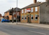
Robin Hood Inn at the corner of Averill Street and Droylsden Road / David Dixon, 9 Apr. 2010, Creative Commons, via Geograph.
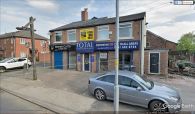
The repurposed Robin Hood / Google Earth Street View.
