
Robin Hood (Mansfield Road, Nottingham)
From International Robin Hood Bibliography
| Locality | |
|---|---|
| Coordinate | 52.980346, -1.146743 |
| Adm. div. | Nottinghamshire |
| Vicinity | 540 Mansfield Road, Nottingham |
| Type | Public house |
| Interest | Robin Hood name |
| Status | Extant |
| First Record | 1898 |
The Robin Hood.

By Henrik Thiil Nielsen, 2013-08-07. Revised by Henrik Thiil Nielsen, 2021-01-06.
The Robin Hood on 540 Mansfield Road in Nottingham was in existene by 1898/99. Information on publicans for the years 1898/99 to 1941 can be found at UK Pub History.[1].Template:PlaceNamesItemQuery
Gazetteers
- Not included in Dobson, R. B., ed.; Taylor, J., ed. Rymes of Robyn Hood: an Introduction to the English Outlaw (London, 1976), pp. 293-311.
Sources
Maps
- 25" O.S. map Nottinghamshire XXXVIII.10 (1883; surveyed 1878-81)
- 25" O.S. map Nottinghamshire XXXVIII.10 (1900; rev. 1899) (georeferenced)
- 25" O.S. map Nottinghamshire XXXVIII.10 (1900; rev. 1899)
- 25" O.S. map Nottinghamshire XXXVIII.10 (1915; rev. 1913)
- 6" O.S. map Nottinghamshire XXXVIII.SW (1885; surveyed 1878-81)
- 6" O.S. map Nottinghamshire XXXVIII.SW (1901; rev. 1899) (georeferenced)
- 6" O.S. map Nottinghamshire XXXVIII.SW (1901; rev. 1899)
- 6" O.S. map Nottinghamshire XXXVIII.SW (1920; rev. 1919)
- 6" O.S. map Nottinghamshire XXXVIII.SW (c. 1947; rev. 1938).
Also see
Notes
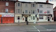
The Robin Hood / Google Earth Steet View.
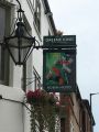
The sign of the Robin Hood / David Lally, 5 Aug. 2017, Creative Commons, via Geograph.

