
Robin Hood (Mansfield Road, Nottingham): Difference between revisions
From International Robin Hood Bibliography
m (Text replacement - "<div class="no-img"><p id="byline">" to "<div class="no-img"> <p id="byline">") |
m (Text replacement - "UK Pub History" to "Pub History") |
||
| (10 intermediate revisions by the same user not shown) | |||
| Line 1: | Line 1: | ||
__NOTOC__{{ | __NOTOC__{{PlaceNamesItemTop|Lat=52.980346|Lon=-1.146743|AdministrativeDivision=Nottinghamshire|Vicinity=540 Mansfield Road, Nottingham|Type=Public house|Interest=Robin Hood name|Status=Extant|Demonym=|Riding=|GreaterLondon=|Year=1898|Aka=|Century=|Cluster1=Nottingham|Cluster2=|Cluster3=|Image=robin-hood-mansfield-road-nottingham-google-earth-street-view.jpg|Postcards=|ExtraCat1=|ExtraCat2=|ExtraCat3=|ExtraCat4=|ExtraCat5=|ExtraLink1=|ExtraLink2=|ExtraLink3=|ExtraLink4=|ExtraLink5=|ExtraLinkName1=|ExtraLinkName2=|ExtraLinkName3=|ExtraLinkName4=|ExtraLinkName5=|GeopointPrefix=|GeopointSuffix=|StatusSuffix=|DatePrefix=|DateSuffix=}} | ||
{{#display_map:{{#var:Coords}}~{{#replace:{{PAGENAME}}|'|'}}|width=34% | {{#display_map:{{#var:Coords}}~{{#replace:{{PAGENAME}}|'|'}}|width=34%|enablefullscreen=yes}}<div class="pnMapLegend">The Robin Hood.</div> | ||
[[File:{{#var: | [[File:{{#var:Image}}|thumb|right|500px|[http://www.geograph.org.uk/photo/5487203 The Robin Hood / Google Earth Steet View.]]]<div class="no-img"> | ||
<p id="byline">By Henrik Thiil Nielsen, 2013-08-07. Revised by {{#realname:{{REVISIONUSER}}}}, {{REVISIONYEAR}}-{{REVISIONMONTH}}-{{REVISIONDAY2}}.</p> | <p id="byline">By Henrik Thiil Nielsen, 2013-08-07. Revised by {{#realname:{{REVISIONUSER}}}}, {{REVISIONYEAR}}-{{REVISIONMONTH}}-{{REVISIONDAY2}}.</p> | ||
The Robin Hood on 540 Mansfield Road in Nottingham was in existene by 1898/99. Information on publicans for the years 1898/99 to 1941 can be found at | The Robin Hood on 540 Mansfield Road in Nottingham was in existene by 1898/99. Information on publicans for the years 1898/99 to 1941 can be found at Pub History.<ref>[https://pubhistory.co.uk//Nottinghamshire/Nottingham/RobinHood.shtml Pub History: Robin Hood, 540 Mansfield Road, Sherwood, Nottingham, Nottinghamshire.]</ref>.{{PlaceNamesItemAllusionsAndRecords}} | ||
== Gazetteers == | == Gazetteers == | ||
| Line 9: | Line 9: | ||
== Sources == | == Sources == | ||
* [https://pubhistory.co.uk//Nottinghamshire/Nottingham/RobinHood.shtml | * [https://pubhistory.co.uk//Nottinghamshire/Nottingham/RobinHood.shtml Pub History: Robin Hood, 540 Mansfield Road, Sherwood, Nottingham, Nottinghamshire.] | ||
== Maps == | == Maps == | ||
| Line 21: | Line 21: | ||
* [https://maps.nls.uk/view/101603121#zoom=5&lat=3832&lon=6170&layers=BT 6" O.S. map ''Nottinghamshire'' XXXVIII.SW (1920; rev. 1919)] | * [https://maps.nls.uk/view/101603121#zoom=5&lat=3832&lon=6170&layers=BT 6" O.S. map ''Nottinghamshire'' XXXVIII.SW (1920; rev. 1919)] | ||
* [https://maps.nls.uk/view/101603118#zoom=5&lat=3815&lon=6157&layers=BT 6" O.S. map ''Nottinghamshire'' XXXVIII.SW (''c.'' 1947; rev. 1938).] | * [https://maps.nls.uk/view/101603118#zoom=5&lat=3815&lon=6157&layers=BT 6" O.S. map ''Nottinghamshire'' XXXVIII.SW (''c.'' 1947; rev. 1938).] | ||
{{ | {{PlaceNamesItemAlsoSee}} | ||
== Notes == | == Notes == | ||
| Line 28: | Line 28: | ||
<div id="gallery"> | <div id="gallery"> | ||
{{ | {{ImageGalleryIntroduction}} | ||
<gallery widths="195px"> | <gallery widths="195px"> | ||
robin-hood-mansfield-road-nottingham-google-earth-street-view.jpg|The Robin Hood / [http://www.geograph.org.uk/photo/5487203 Google Earth Steet View.] | robin-hood-mansfield-road-nottingham-google-earth-street-view.jpg|The Robin Hood / [http://www.geograph.org.uk/photo/5487203 Google Earth Steet View.] | ||
| Line 36: | Line 36: | ||
</div> | </div> | ||
{{ | {{PlaceNamesItemNavigation}} | ||
Latest revision as of 15:30, 5 May 2022
| Locality | |
|---|---|
| Coordinate | 52.980346, -1.146743 |
| Adm. div. | Nottinghamshire |
| Vicinity | 540 Mansfield Road, Nottingham |
| Type | Public house |
| Interest | Robin Hood name |
| Status | Extant |
| First Record | 1898 |
The Robin Hood.

By Henrik Thiil Nielsen, 2013-08-07. Revised by Henrik Thiil Nielsen, 2022-05-05.
The Robin Hood on 540 Mansfield Road in Nottingham was in existene by 1898/99. Information on publicans for the years 1898/99 to 1941 can be found at Pub History.[1].
Gazetteers
- Not included in Dobson, R. B., ed.; Taylor, J., ed. Rymes of Robyn Hood: an Introduction to the English Outlaw (London, 1976), pp. 293-311.
Sources
Maps
- 25" O.S. map Nottinghamshire XXXVIII.10 (1883; surveyed 1878-81)
- 25" O.S. map Nottinghamshire XXXVIII.10 (1900; rev. 1899) (georeferenced)
- 25" O.S. map Nottinghamshire XXXVIII.10 (1900; rev. 1899)
- 25" O.S. map Nottinghamshire XXXVIII.10 (1915; rev. 1913)
- 6" O.S. map Nottinghamshire XXXVIII.SW (1885; surveyed 1878-81)
- 6" O.S. map Nottinghamshire XXXVIII.SW (1901; rev. 1899) (georeferenced)
- 6" O.S. map Nottinghamshire XXXVIII.SW (1901; rev. 1899)
- 6" O.S. map Nottinghamshire XXXVIII.SW (1920; rev. 1919)
- 6" O.S. map Nottinghamshire XXXVIII.SW (c. 1947; rev. 1938).
Also see
Notes
Image gallery
Click any image to display it in the lightbox, where you can navigate between images by clicking in the right or left side of the current image.
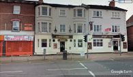
The Robin Hood / Google Earth Steet View.
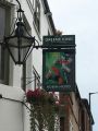
The sign of the Robin Hood / David Lally, 5 Aug. 2017, Creative Commons, via Geograph.

