
Robin Hood (Little John Lakes, New Ollerton): Difference between revisions
m (→Maps) |
m (Text replacement - "No Copy in NLS" to "No copy in NLS") |
||
| (17 intermediate revisions by 2 users not shown) | |||
| Line 1: | Line 1: | ||
__NOTOC__{{ | __NOTOC__{{PlaceNamesItemTop|Lat=53.205375|Lon=-1.019101|AdministrativeDivision=Nottinghamshire|Vicinity=By River Maun, immediately W of Maida Lane|Type=Natural feature|Interest=Robin Hood name|Status=Extant|Demonym=English|Riding=|GreaterLondon=|Year=2006|Aka=|Century=|Cluster1=Little John Lakes (New Ollerton)|Cluster2=New Ollerton|Cluster3=|Image=robin-hood-little-john-lakes-ollerton-google-earth-street-view.jpg|Postcards=|ExtraCat1=|ExtraCat2=|ExtraCat3=|ExtraCat4=|ExtraCat5=|ExtraLink1=|ExtraLink2=|ExtraLink3=|ExtraLink4=|ExtraLink5=|ExtraLinkName1=|ExtraLinkName2=|ExtraLinkName3=|ExtraLinkName4=|ExtraLinkName5=|GeopointPrefix=|GeopointSuffix=|StatusSuffix=|DatePrefix=''c.'' |DateSuffix=}} | ||
{{#display_map:{{#var:Coords}}~{{#replace:{{PAGENAME}}|'|'}}|width=34% | {{#display_map:{{#var:Coords}}~{{#replace:{{PAGENAME}}|'|'}}|width=34%|enablefullscreen=yes}}<div class="pnMapLegend">One of three three Little John lakes in New Ollerton is named Robin Hood.</div> | ||
[[File:{{#var: | [[File:{{#var:Image}}|thumb|right|500px|Robin Hood lake, Little John Lakes, New Ollerton / Google Earth Street View.]] | ||
<p id="byline">By Henrik Thiil Nielsen, 2018-05-21. Revised by {{#realname:{{REVISIONUSER}}}}, {{REVISIONYEAR}}-{{REVISIONMONTH}}-{{REVISIONDAY2}}.</p> | |||
<p id="byline">By Henrik Thiil Nielsen, 2018-05-21. Revised by {{#realname:{{REVISIONUSER}}}}, {{REVISIONYEAR}}-{{REVISIONMONTH}}-{{REVISIONDAY2}}.</p | |||
'Robin Hood' is the name of one of three artificial fishing lakes known collectively as 'Little John Lakes' by River Maun on the west side of Maida Lane in Ollerton. The other lakes are named [[Maid Marion (Little John Lakes, New Ollerton)|Maid Marion]] and [[Friar Tuck (Little John Lakes, New Ollerton)|Friar Tuck]]. Little John Lakes opened in 2006,<ref>[https://www.nottinghampost.com/whats-on/whats-on-news/no-shortage-places-fish-172472 Anonymous. 'No Shortage of Places to Fish: the Nottingham and Erewash Canals are Alive', ''Nottingham Post'' (2012-04-26).]</ref> but it is not clear if all three lakes had been established by that time. | 'Robin Hood' is the name of one of three artificial fishing lakes known collectively as 'Little John Lakes' by River Maun on the west side of Maida Lane in Ollerton. The other lakes are named [[Maid Marion (Little John Lakes, New Ollerton)|Maid Marion]] and [[Friar Tuck (Little John Lakes, New Ollerton)|Friar Tuck]]. Little John Lakes opened in 2006,<ref>[https://www.nottinghampost.com/whats-on/whats-on-news/no-shortage-places-fish-172472 Anonymous. 'No Shortage of Places to Fish: the Nottingham and Erewash Canals are Alive', ''Nottingham Post'' (2012-04-26).]</ref> but it is not clear if all three lakes had been established by that time. | ||
For statistical purposes the lakes have been categorized as 'Natural feature', which is paradoxically the best fit given the categories in use at IRHB.{{ | For statistical purposes the lakes have been categorized as 'Natural feature', which is paradoxically the best fit given the categories in use at IRHB. | ||
{{PlaceNamesItemAllusionsAndRecords}} | |||
== Gazetteers == | |||
* Not included in {{:Dobson, Richard Barrie 1976a}}, pp. 293-311. | |||
== Sources == | == Sources == | ||
* [https://www.nottinghampost.com/whats-on/whats-on-news/no-shortage-places-fish-172472 Anonymous. 'No Shortage of Places to Fish: the Nottingham and Erewash Canals are Alive', ''Nottingham Post'' (2012-04-26)]<ref>As of 22 May 2018, the article is dated "26 APR 2102". Presumably the year is 2012.</ref> | * [https://www.nottinghampost.com/whats-on/whats-on-news/no-shortage-places-fish-172472 Anonymous. 'No Shortage of Places to Fish: the Nottingham and Erewash Canals are Alive', ''Nottingham Post'' (2012-04-26)]<ref>As of 22 May 2018, the article is dated "26 APR 2102". Presumably the year is 2012.</ref> | ||
| Line 13: | Line 15: | ||
* [https://littlejohnlakes.weebly.com/index.html Little John Lakes.] | * [https://littlejohnlakes.weebly.com/index.html Little John Lakes.] | ||
== Maps == | == Maps == | ||
* 25" O.S. map ''Nottinghamshire'' XIX.14 (''c.'' 1885; surveyed ''c.'' 1884). No | * 25" O.S. map ''Nottinghamshire'' XIX.14 (''c.'' 1885; surveyed ''c.'' 1884). No copy in NLS | ||
* 25" O.S. map ''Nottinghamshire'' XIX.14 (''c.'' 1899; rev. ''c.'' 1897-98). No | * 25" O.S. map ''Nottinghamshire'' XIX.14 (''c.'' 1899; rev. ''c.'' 1897-98). No copy in NLS | ||
* [https://maps.nls.uk/view/115390111#zoom=3&lat=8967&lon=5541&layers=BT 25" O.S. map ''Nottinghamshire'' XIX.14 (1920; rev. 1915)] | * [https://maps.nls.uk/view/115390111#zoom=3&lat=8967&lon=5541&layers=BT 25" O.S. map ''Nottinghamshire'' XIX.14 (1920; rev. 1915)] | ||
* [http://maps.nls.uk/geo/explore/#zoom=17&lat=53.2036&lon=-1.0202&layers=168&b=5 25" O.S. map ''Nottinghamshire'' XIX.13 (1920; rev. 1915)] (georeferenced) | * [http://maps.nls.uk/geo/explore/#zoom=17&lat=53.2036&lon=-1.0202&layers=168&b=5 25" O.S. map ''Nottinghamshire'' XIX.13 (1920; rev. 1915)] (georeferenced) | ||
| Line 27: | Line 29: | ||
* [http://www.pressreader.com/uk/angling-times-uk/20160531/281848642853790 Anonymous. 'Little John Lakes, New Ollerton, Notts (Angling Times, 2016-05-31)] | * [http://www.pressreader.com/uk/angling-times-uk/20160531/281848642853790 Anonymous. 'Little John Lakes, New Ollerton, Notts (Angling Times, 2016-05-31)] | ||
* [http://www.drennantackle.com/fisheries/little-john-lakes/ Drennan: Little John Lakes] | * [http://www.drennantackle.com/fisheries/little-john-lakes/ Drennan: Little John Lakes] | ||
* [https://youtu.be/N4OSJn3DeXs Youtube: BagUpTV: Little John Lakes – Robin Hood | * [https://youtu.be/N4OSJn3DeXs Youtube: BagUpTV: Little John Lakes – Robin Hood] (now only viewable by paying members). | ||
<!--== Brief mention ==--> | <!--== Brief mention ==--> | ||
{{ | {{PlaceNamesItemAlsoSee}} | ||
== Notes == | == Notes == | ||
<references/> | <references/> | ||
</div> | |||
< | <div id="gallery"> | ||
{{ | {{ImageGalleryIntroduction}} | ||
<gallery widths="195px"> | <gallery widths="195px"> | ||
File:robin-hood-little-john-lakes-ollerton-google-earth-1.jpg|The aerial photos for Google Earth's satellite view (as of 21 May 2018) were taken when Robin Hood, to the left, was still under construction / Google Earth. | File:robin-hood-little-john-lakes-ollerton-google-earth-1.jpg|The aerial photos for Google Earth's satellite view (as of 21 May 2018) were taken when Robin Hood, to the left, was still under construction / Google Earth. | ||
File:robin-hood-little-john-lakes-ollerton-google-earth-street-view.jpg|When The Google Street View photo car came round, Robin Hood was ready for action / Google Earth Street View. | File:robin-hood-little-john-lakes-ollerton-google-earth-street-view.jpg|When The Google Street View photo car came round, Robin Hood was ready for action / Google Earth Street View. | ||
File:robin-hood-little-john-lakes-ollerton-bag-up-tv-youtube.jpg|Match fishing TV still image from Robin Hood lake / [https://youtu.be/N4OSJn3DeXs Youtube: Bag Up TV] | File:robin-hood-little-john-lakes-ollerton-bag-up-tv-youtube.jpg|Match fishing TV still image from Robin Hood lake / [https://youtu.be/N4OSJn3DeXs Youtube: Bag Up TV] (now only viewable by paying members). | ||
</gallery> | </gallery> | ||
</div> | |||
{{PlaceNamesItemNavigation}} | |||
{{ | |||
Latest revision as of 01:09, 13 February 2021
| Locality | |
|---|---|
| Coordinate | 53.205375, -1.019101 |
| Adm. div. | Nottinghamshire |
| Vicinity | By River Maun, immediately W of Maida Lane |
| Type | Natural feature |
| Interest | Robin Hood name |
| Status | Extant |
| First Record | c. 2006 |

By Henrik Thiil Nielsen, 2018-05-21. Revised by Henrik Thiil Nielsen, 2021-02-13.
'Robin Hood' is the name of one of three artificial fishing lakes known collectively as 'Little John Lakes' by River Maun on the west side of Maida Lane in Ollerton. The other lakes are named Maid Marion and Friar Tuck. Little John Lakes opened in 2006,[1] but it is not clear if all three lakes had been established by that time.
For statistical purposes the lakes have been categorized as 'Natural feature', which is paradoxically the best fit given the categories in use at IRHB.
Gazetteers
- Not included in Dobson, R. B., ed.; Taylor, J., ed. Rymes of Robyn Hood: an Introduction to the English Outlaw (London, 1976), pp. 293-311.
Sources
- Anonymous. 'No Shortage of Places to Fish: the Nottingham and Erewash Canals are Alive', Nottingham Post (2012-04-26)[2]
- Facebook: Little John Lakes
- Little John Lakes.
Maps
- 25" O.S. map Nottinghamshire XIX.14 (c. 1885; surveyed c. 1884). No copy in NLS
- 25" O.S. map Nottinghamshire XIX.14 (c. 1899; rev. c. 1897-98). No copy in NLS
- 25" O.S. map Nottinghamshire XIX.14 (1920; rev. 1915)
- 25" O.S. map Nottinghamshire XIX.13 (1920; rev. 1915) (georeferenced)
- 25" O.S. map Nottinghamshire XIX.14 (1945; rev. 1938).
- 6" O.S. map Nottinghamshire XIX.SW (1884; surveyed 1882)
- 6" O.S. map Nottinghamshire XIX.SW (1900; rev. 1897-99)
- 6" O.S. map Nottinghamshire XIX.SW (1900; rev. 1897-99) (georeferenced)
- 6" O.S. map Nottinghamshire XIX.SW (1921; rev. 1915).
Background
- Anonymous. 'Little John Lakes, New Ollerton, Notts (Angling Times, 2016-05-31)
- Drennan: Little John Lakes
- Youtube: BagUpTV: Little John Lakes – Robin Hood (now only viewable by paying members).
Also see
Notes
- ↑ Anonymous. 'No Shortage of Places to Fish: the Nottingham and Erewash Canals are Alive', Nottingham Post (2012-04-26).
- ↑ As of 22 May 2018, the article is dated "26 APR 2102". Presumably the year is 2012.
Image gallery
Click any image to display it in the lightbox, where you can navigate between images by clicking in the right or left side of the current image.
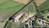
The aerial photos for Google Earth's satellite view (as of 21 May 2018) were taken when Robin Hood, to the left, was still under construction / Google Earth.
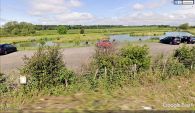
When The Google Street View photo car came round, Robin Hood was ready for action / Google Earth Street View.
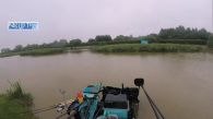
Match fishing TV still image from Robin Hood lake / Youtube: Bag Up TV (now only viewable by paying members).

