
Robin Hood (Guildford): Difference between revisions
m (Text replacement - "Creative Commons via Geograph" to "Creative Commons, via Geograph") |
rh>Henryfunk mNo edit summary |
||
| Line 35: | Line 35: | ||
== Notes == | == Notes == | ||
<references/> | <references/> | ||
</div> | |||
< | <div id="gallery"> | ||
{{ImgGalleryIntro}} | {{ImgGalleryIntro}} | ||
<gallery widths="195px"> | <gallery widths="195px"> | ||
| Line 52: | Line 53: | ||
robin-hood-guildford-surrey-google-earth-street-view-3.jpg|The Robin Hood, from the west / Google Earth Street View | robin-hood-guildford-surrey-google-earth-street-view-3.jpg|The Robin Hood, from the west / Google Earth Street View | ||
</gallery> | </gallery> | ||
</div> | |||
{{PnItemNav}} | {{PnItemNav}} | ||
Revision as of 16:44, 15 May 2020
[[File:|thumb|right|500px|Robin Hood, Sydenham Road, reopened / L.S. Wilson, 18 Dec. 2010, Creative Commons, via Geograph.]]
By Henrik Thiil Nielsen, 2013-08-07. Revised by 3.145.23.123, 2020-05-15.
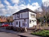
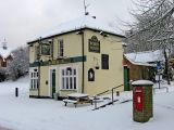
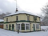
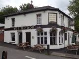
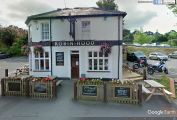
The Robin Hood at 19 Sydenham Road, Guildford, Surrey, is listed in Kelly's Directory for 1878, and it probably is not much older than this, for the building is said to date from c. 1865.[1] The pub closed in the spring of 2010 but reopened later same year under new management.[2] Information on publicans for the period 1878-1937 can be found at UK Pub History.[3]Template:PnItemQry
Gazetteers
- Not included in Dobson, R. B., ed.; Taylor, J., ed. Rymes of Robyn Hood: an Introduction to the English Outlaw (London, 1976), pp. 293-311.
Sources
Maps
- 25" O.S. map Surrey XXIII.16 (c. 1873; surveyed c. 1870-71). No Copy in NLS
- 25" O.S. map Surrey XXIII.16 (1896; rev. 1895) (georeferenced)
- 25" O.S. map Surrey XXIII.16 (1896; rev. 1895)
- 25" O.S. map Surrey XXIII.16 (1916; rev. 1913)
- 25" O.S. map Surrey XXIII.16 (1935; rev. 1934)
- 6" O.S. map Surrey XXIII (1873; surveyed 1870-71)
- 6" O.S. map Surrey XXIII.SE (1897; rev. 1895) (georeferenced)
- 6" O.S. map Surrey XXIII.SE (1897; rev. 1895)
- 6" O.S. map Surrey XXIII.SE (1920; rev. 1913)
- 6" O.S. map Surrey XXIII.SE (1936; rev. 1934)
- 6" O.S. map Surrey XXIII.SE (c. 1944; rev. 1938)
- 6" O.S. map Surrey XXIII.SE (c. 1947; rev. 1938)
- 6" O.S. map Surrey XXIII.SE (c. 1954; rev. 1938).
Background
Notes
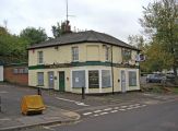
The Robin Hood, Guildford, reopened / Len Williams, 6 Feb. 2015, Creative Commons, via Geograph.
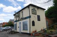
Robin Hood, Sydenham Road, reopened / L.S. Wilson, 18 Dec. 2010, Creative Commons, via Geograph.
Robin Hood, Sydenham Road, reopened / L.S. Wilson, 18 Dec. 2010, Creative Commons, via Geograph.

Sign of the Robin Hood, Sydenham Road / P.L. Chadwick, 18 Dec. 2010, Creative Commons, via Geograph.
The Robin Hood / Colin Smith, 19 Jul. 2012, Creative Commons, via Geograph.
Robin Hood, Sydenham Road, closed / N. Chadwick, 3 Jul. 2010, Creative Commons, via Geograph.
Robin Hood, Sydenham Road, closed / P.L. Chadwick, 4. Oct. 2010, Creative Commons, via Geograph.
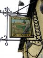
Sign of the Robin Hood, Sydenham Road / P.L. Chadwick, 4. Oct. 2010, Creative Commons, via Geograph.
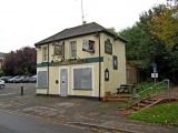
Robin Hood, Sydenham Road, closed / P.L. Chadwick, 4. Oct. 2010, Creative Commons, via Geograph.
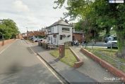
The Robin Hood, from the northwest / Google Earth Street View
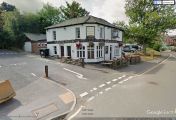
The Robin Hood, from the northeast / Google Earth Street View
The Robin Hood, from the west / Google Earth Street View


