
Robin Hood (Enfield)
| Locality | |
|---|---|
| Coordinate | 51.676189, -0.12653 |
| Adm. div. | Middlesex, now Greater London |
| Vicinity | The Ridgeway, Botany Bay, Enfield |
| Type | Public house |
| Interest | Robin Hood name |
| Status | Extant |
| First Record | 1881 |

By Henrik Thiil Nielsen, 2013-08-07. Revised by Henrik Thiil Nielsen, 2021-01-05.
Still going strong, the Robin Hood in Botany Bay, Enfield, was in existence by 1881.[1]It is doubtful if the pub is much older than this, for while it is included on O.S. maps published in the 1890s, it is missing from maps published in the 1860s (see Maps below). The excellent Pub Wiki provides information on publicans and residents for the years 1881–1937.[2] Template:PnItemQry
Gazetteers
- Not included in Dobson, R. B., ed.; Taylor, J., ed. Rymes of Robyn Hood: an Introduction to the English Outlaw (London, 1976), pp. 293-311.
Sources
Maps
- 6" O.S. map Middlesex II (1868; surveyed 1866)
- 6" O.S. map Middlesex II.SW (1897; rev. 1895) (georeferenced)
- 6" O.S. map Middlesex II.SW (1897; rev. 1895)
- 6" O.S. map Hertfordshire XLI.SW (1920; rev. 1912)
- 6" O.S. map Hertfordshire XLI.SW (c. 1946; rev. 1938)
- 25" O.S. map Middlesex II.13 (1866; surveyed 1866)
- 25" O.S. map Middlesex II.13 (1896; rev. 1895) (georeferenced)
- 25" O.S. map Middlesex II.13 (1896; rev. 1895)
- 25" O.S. map Middlesex II.13 (1913; rev. 1911)
- 25" O.S. map Middlesex II.13 (1937; rev. 1935).
Background
Notes
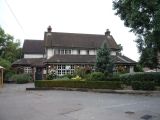
The Robin Hood public house, Enfield; on The Ridgeway (A1005) / J. M. Thomas, 3 Sep. 2016, Creative Commons, via Geograph.

The Robin Hood, The Ridgeway, Enfield / Christine Matthews, 25 Mar. 2008, Creative Commons, via Geograph.
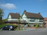
The Robin Hood, Botany Bay / Stephen Dawson, 14 May 2005, Creative Commons, via Geograph.
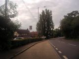
Bus stop by the Robin Hood pub, The Ridgeway / Davi Howard, 19 July 2012, Creative Commons, via Geograph.
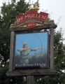
Sign for the Robin Hood public house, Enfield / J. M. Thomas, 3 Sep. 2016, Creative Commons, via Geograph.

The Robin Hood / Google Earth Street View.
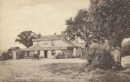
Anonymous. "The Robin Hood", Botany Bay ([s.l.], [s.d.]). Photographic postcard (monochrome). 138 x 87 mm.; dated c. 1910 cf. Pub History; MS note "8/12" on dorse of IRHB copy may suggest 1912 / HTN collection


