
Robin Hood (Edwinstowe)

By Henrik Thiil Nielsen, 2013-08-07. Revised by Henrik Thiil Nielsen, 2018-10-16.
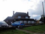
A public house adjacent to Robin Hood Farm. The first record of this place-name I have found is the 6" O.S. map of the area published in 1900, based on a survey carried out in 1897 (see Maps section below). The inn is indicated there as Robin Hood Inn. However, already on the 1884 map, the word "Inn" appears next to Robin Hood Farm. The Robin Hood is still in business.
The junction where the pub is situated is known as the Robin Hood Junction. There is a Robin Hood Avenue in the immediate vicinity.Template:PnItemQry
Maps
- 6" O.S. map Nottinghamshire XXIII.NE (1884; surveyed 1883-84)
- 6" O.S. map Nottinghamshire XXIII.NE (1900; rev. 1897)
- 6" O.S. map Nottinghamshire XXIII.NE (1920; rev. 1914)
- 6" O.S. map Nottinghamshire XXIII.NE (c. 1948; rev. 1938).
Background
Robin Hood Crossroads with the sign of the Robin Hood (1980) / Ian S, 18 Mar. 2012; Creative Commons via Geograph.
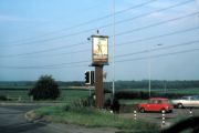
Robin Hood Crossroads with the sign of the Robin Hood / Helmut Zozmann, July 1980; Creative Commons via Geograph.

