
Robin Hood (Durley Street): Difference between revisions
m (Text replacement - "Creative Commons via Geograph" to "Creative Commons, via Geograph") |
m (Text replacement - "* 25" map" to "* 25" O.S. map") |
||
| (26 intermediate revisions by 2 users not shown) | |||
| Line 1: | Line 1: | ||
__NOTOC__{{ | __NOTOC__{{PlaceNamesItemTop|Lat=50.956581|Lon=-1.249963|AdministrativeDivision=Hampshire|Vicinity=Durley Street|Type=Public house|Interest=Robin Hood name|Status=Extant|Demonym=|Riding=|GreaterLondon=|Year=1855|Aka=|Century=|Cluster1=Bishop's Waltham|Cluster2=|Cluster3=|Image=robin-hood-durley-street-google-earth-street-view.jpg|Postcards=|ExtraCat1=Places named after Little John|ExtraCat2=|ExtraCat3=|ExtraCat4=|ExtraCat5=|ExtraLink1=|ExtraLink2=|ExtraLink3=|ExtraLink4=|ExtraLink5=|ExtraLinkName1=|ExtraLinkName2=|ExtraLinkName3=|ExtraLinkName4=|ExtraLinkName5=|GeopointPrefix=|GeopointSuffix=|StatusSuffix=|DatePrefix=|DateSuffix=}} | ||
{{#display_map:{{#var:Coords}}~{{#replace:{{PAGENAME}}|'|'}}|width=34% | {{#display_map:{{#var:Coords}}~{{#replace:{{PAGENAME}}|'|'}}|width=34%|enablefullscreen=yes}}<div class="pnMapLegend">The Robin Hood.</div> | ||
[[File:robin-hood-durley-street-google-earth-street-view.jpg|thumb|right|500px|The Robin Hood in Durley Street / Google Maps Street View.]] | [[File:robin-hood-durley-street-google-earth-street-view.jpg|thumb|right|500px|The Robin Hood in Durley Street / Google Maps Street View.]]<div class="no-img"> | ||
<p id="byline">By Henrik Thiil Nielsen, 2014-09-25. Revised by {{#realname:{{REVISIONUSER}}}}, {{REVISIONYEAR}}-{{REVISIONMONTH}}-{{REVISIONDAY2}}.</p> | <p id="byline">By Henrik Thiil Nielsen, 2014-09-25. Revised by {{#realname:{{REVISIONUSER}}}}, {{REVISIONYEAR}}-{{REVISIONMONTH}}-{{REVISIONDAY2}}.</p> | ||
The Robin Hood on 'Durley Street' in the hamlet of 'Durley Street' was in existence by 1855 and as late as 1927 if not later. | |||
The Robin Hood on | |||
The pub figures in Kelly and Co.'s ''Post Office Directory of Hampshire, Wiltshire, and Dorsetshire'' (1855) as the 'Robin Hood', with John Browning as publican and locality given as 'Durley, Botley'.<ref>{{:Kelly, E R 1855b}}, Hampshire, pp. 42, 301; [https://pubwiki.co.uk/Hampshire/Hampshire1855/Hampshire1855QR.shtml Public Houses, Inns & Taverns of Hampshire in 1855 - QR].</ref> It is included as 'Robin Hood & Little John', on a 6" O.S. map of the area published in 1871, while two later 6" O.S. maps omit the pub's name, providing only the indication 'Inn'. Pub History lists publican information for the years 1911 and 1927.<ref>[https://pubwiki.co.uk/Hampshire/Durley/RobinHood.shtml Pub History: Robin Hood, Durley, Hampshire]; [https://pubwiki.co.uk/Hampshire/Hampshire1911/Hampshire1911QR.shtml Public Houses, Inns & Taverns of Hampshire in 1911 - QR]</ref>{{PlaceNamesItemAllusionsAndRecords}} | |||
== Gazetteers == | == Gazetteers == | ||
* Not included in {{:Dobson, Richard Barrie 1976a|Dobson & Taylor}}, pp. 293-311. | * Not included in {{:Dobson, Richard Barrie 1976a|Dobson & Taylor}}, pp. 293-311. | ||
== Sources == | == Sources == | ||
* [https:// | * {{:Kelly, E R 1855b}}, Hampshire, pp. 42, 301 | ||
* [https://pubwiki.co.uk/Hampshire/Durley/RobinHood.shtml Pub History: Robin Hood, Durley, Hampshire]; and [https://pubwiki.co.uk/Hampshire/Hampshire1855/Hampshire1855QR.shtml Public Houses, Inns & Taverns of Hampshire in 1855 - QR] | |||
** [https://pubwiki.co.uk/Hampshire/Hampshire1911/Hampshire1911QR.shtml Public Houses, Inns & Taverns of Hampshire in 1911 - QR] | |||
== Maps == | == Maps == | ||
* 25" O.S. map ''Hampshire & Isle of Wight'' LVIII.11 (''c.'' 1869; surveyed 1866). No copy in NLS | |||
* 25" O.S. map ''Hampshire & Isle of Wight'' LVIII.11 (''c.'' 1896; rev. ''c.'' 1895). No copy in NLS | |||
* [https://maps.nls.uk/geo/explore/#zoom=18&lat=50.95650&lon=-1.25032&layers=168&b=5 25" O.S. map ''Hampshire & Isle of Wight'' LVIII.11 (1909; rev. 1908)] (georeferenced) | |||
* [https://maps.nls.uk/view/105986575#zoom=6&lat=2104&lon=8305&layers=BT 25" O.S. map ''Hampshire & Isle of Wight'' LVIII.11 (1909; rev. 1908)] | |||
* [https://maps.nls.uk/view/105986572#zoom=6&lat=1977&lon=7906&layers=BT 25" O.S. map ''Hampshire & Isle of Wight'' LVIII.11 (1946; rev. 1940)] | |||
* [http://maps.nls.uk/view/102343101#zoom=6&lat=3304&lon=9681&layers=BT 6" O.S. map ''Hampshire & Isle of Wight'' LVIII (1871; surveyed 1863)] | * [http://maps.nls.uk/view/102343101#zoom=6&lat=3304&lon=9681&layers=BT 6" O.S. map ''Hampshire & Isle of Wight'' LVIII (1871; surveyed 1863)] | ||
* [http://maps.nls.uk/view/101441199#zoom=5&lat=3868&lon=2755&layers=BT 6" O.S. map ''Hampshire & Isle of Wight'' LVIII.SE (1897; rev. 1895)] | * [https://maps.nls.uk/geo/explore/#zoom=17&lat=50.95649&lon=-1.25132&layers=6&b=5 6" O.S. map ''Hampshire & Isle of Wight'' LVIII.SE (1897; rev. 1895)] (georeferenced) | ||
* [http://maps.nls.uk/geo/explore/#zoom=17&lat=50.9560&lon=-1.2503&layers=6&b=1 6" O.S. map ''Hampshire & Isle of Wight'' LVIII.SE (1897; rev. 1895)] (georeferenced | * [http://maps.nls.uk/view/101441199#zoom=5&lat=3868&lon=2755&layers=BT 6" O.S. map ''Hampshire & Isle of Wight'' LVIII.SE (1897; rev. 1895)] | ||
* [http://maps.nls.uk/view/101441196#zoom=5&lat=4029&lon=2802&layers=BT 6" O.S. map ''Hampshire & Isle of Wight'' LVIII.SE (1910; rev. 1908)] | * [http://maps.nls.uk/geo/explore/#zoom=17&lat=50.9560&lon=-1.2503&layers=6&b=1 6" O.S. map ''Hampshire & Isle of Wight'' LVIII.SE (1897; rev. 1895)] (georeferenced) | ||
* [http://maps.nls.uk/view/101441196#zoom=5&lat=4029&lon=2802&layers=BT 6" O.S. map ''Hampshire & Isle of Wight'' LVIII.SE (1910; rev. 1908).] | |||
== Background == | == Background == | ||
* [https://www.facebook.com/Robin-Hood-Pub-Durley-145553205486483/ Facebook: Robin Hood Pub, Durley] | * [https://www.facebook.com/Robin-Hood-Pub-Durley-145553205486483/ Facebook: Robin Hood Pub, Durley] | ||
* [www.therobinhooddurley.co.uk The Robin Hood] (the pub's website) | * [https://www.therobinhooddurley.co.uk The Robin Hood] (the pub's website) | ||
* [https://en.wikipedia.org/wiki/Durley_Street Wikipedia: Durley Street.] | * [https://en.wikipedia.org/wiki/Durley_Street Wikipedia: Durley Street.] | ||
{{ | {{PlaceNamesItemAlsoSee}} | ||
== Notes == | == Notes == | ||
<references/> | <references/> | ||
</div> | |||
< | <div id="gallery"> | ||
{{ | {{ImageGalleryIntroduction}} | ||
<gallery widths="195px"> | <gallery widths="195px"> | ||
robin-hood-durley-street-google-earth-street-view.jpg|The Robin Hood in Durley Street / Google Maps Street View. | robin-hood-durley-street-google-earth-street-view.jpg|The Robin Hood in Durley Street / Google Maps Street View. | ||
geograph-057205-by-Peter-Facey.jpg|On Durley Street in Durley Street. The Robin Hood Inn is on a crossroads just beyond the brown car | geograph-057205-by-Peter-Facey.jpg|On Durley Street in Durley Street. The Robin Hood Inn is on a crossroads just beyond the brown car / [http://www.geograph.org.uk/photo/57205 Peter Facey, 24 Sep. 2015, Creative Commons, via Geograph.] | ||
</gallery> | </gallery> | ||
</div> | |||
{{ | {{PlaceNamesItemNavigation}} | ||
Latest revision as of 16:43, 8 May 2022
| Locality | |
|---|---|
| Coordinate | 50.956581, -1.249963 |
| Adm. div. | Hampshire |
| Vicinity | Durley Street |
| Type | Public house |
| Interest | Robin Hood name |
| Status | Extant |
| First Record | 1855 |

By Henrik Thiil Nielsen, 2014-09-25. Revised by Henrik Thiil Nielsen, 2022-05-08.
The Robin Hood on 'Durley Street' in the hamlet of 'Durley Street' was in existence by 1855 and as late as 1927 if not later.
The pub figures in Kelly and Co.'s Post Office Directory of Hampshire, Wiltshire, and Dorsetshire (1855) as the 'Robin Hood', with John Browning as publican and locality given as 'Durley, Botley'.[1] It is included as 'Robin Hood & Little John', on a 6" O.S. map of the area published in 1871, while two later 6" O.S. maps omit the pub's name, providing only the indication 'Inn'. Pub History lists publican information for the years 1911 and 1927.[2]
Gazetteers
- Not included in Dobson, R. B., ed.; Taylor, J., ed. Rymes of Robyn Hood: an Introduction to the English Outlaw (London, 1976), pp. 293-311.
Sources
- [Kelly, E. R.], compil. Post Office Directory of Hampshire, Wiltshire, and Dorsetshire (London, 1855), Hampshire, pp. 42, 301
- Pub History: Robin Hood, Durley, Hampshire; and Public Houses, Inns & Taverns of Hampshire in 1855 - QR
Maps
- 25" O.S. map Hampshire & Isle of Wight LVIII.11 (c. 1869; surveyed 1866). No copy in NLS
- 25" O.S. map Hampshire & Isle of Wight LVIII.11 (c. 1896; rev. c. 1895). No copy in NLS
- 25" O.S. map Hampshire & Isle of Wight LVIII.11 (1909; rev. 1908) (georeferenced)
- 25" O.S. map Hampshire & Isle of Wight LVIII.11 (1909; rev. 1908)
- 25" O.S. map Hampshire & Isle of Wight LVIII.11 (1946; rev. 1940)
- 6" O.S. map Hampshire & Isle of Wight LVIII (1871; surveyed 1863)
- 6" O.S. map Hampshire & Isle of Wight LVIII.SE (1897; rev. 1895) (georeferenced)
- 6" O.S. map Hampshire & Isle of Wight LVIII.SE (1897; rev. 1895)
- 6" O.S. map Hampshire & Isle of Wight LVIII.SE (1897; rev. 1895) (georeferenced)
- 6" O.S. map Hampshire & Isle of Wight LVIII.SE (1910; rev. 1908).
Background
- Facebook: Robin Hood Pub, Durley
- The Robin Hood (the pub's website)
- Wikipedia: Durley Street.
Also see
- Bishop's Waltham place-name cluster
- Places named after Little John
- Public houses named after Robin Hood.
Notes
Image gallery
Click any image to display it in the lightbox, where you can navigate between images by clicking in the right or left side of the current image.
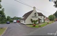
The Robin Hood in Durley Street / Google Maps Street View.
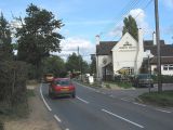
On Durley Street in Durley Street. The Robin Hood Inn is on a crossroads just beyond the brown car / Peter Facey, 24 Sep. 2015, Creative Commons, via Geograph.
