
Robin Hood (Distington)
| Locality | |
|---|---|
| Coordinates | 54.584665, -3.549601 |
| Adm. div. | Cumberland |
| Vicinity | c. 1.8 km SSW of Distington |
| Type | Public house |
| Interest | Robin Hood name |
| Status | Defunct |
| First Record | 1839 |
| A.k.a. | Robin Hood Inn; Robin Hood Cottage |


By Henrik Thiil Nielsen, 2017-02-23. Revised by Henrik Thiil Nielsen, 2017-09-25.
The Robin Hood, a.k.a. the Robin Hood Inn, c. 1.8 km SSW of Distington, is indicated on a map in an 1839 book on the Lake District.[1] It was in existence at least as late as 1947.[2] In 1901 it was run by a William Crone.[3] While the former pub now seems to be a family home (see Google Earth StreetView photo below), it is (also) listed as a small business under the name of Robin Hood Cottage.[4]
Gazetteers
- Not included in Dobson, R. B., ed.; Taylor, J., ed. Rymes of Robyn Hood: an Introduction to the English Outlaw (London, 1976), pp. 293-311.
Sources
- Routledge, Alan W., compil. Whitehaven & Around from Old Photographs (Stroud, Gloucestershire, 2016) (ebook).
Maps
- Ford, William. A Description of the Scenery in the Lake District, intended as a Guide to Strangers (Carlisle, 1839), frontis.
- 6" O.S. map Cumberland LXI (1867; surveyed 1861-64)
- 6" O.S. map Cumberland LXI.SE (1867; rev. 1861-64) (georeferenced)
- 6" O.S. map Cumberland LXI (1900; rev. 1898)
- 6" O.S. map Cumberland LXI (1926; rev. 1923)
- 6" O.S. map Cumberland LXI (c. 1947; rev. 1938)
- 6" O.S. map Cumberland LXI (1951; rev. 1947).
Background
Also see
Notes
- ↑ Ford, William. A Description of the Scenery in the Lake District, intended as a Guide to Strangers (Carlisle, 1839), frontis.
- ↑ 6" O.S. map Cumberland LXI (1951; rev. 1947).
- ↑ Routledge, Alan W., compil. Whitehaven & Around from Old Photographs (Stroud, Gloucestershire, 2016) (ebook).
- ↑ Addresses & Postcodes: Robin Hood Cottage, Distington.
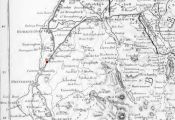
The Robin Hood is shown on this 1839 map near the point I have indicated with a red dot / Ford, William. A Description of the Scenery in the Lake District, intended as a Guide to Strangers (Carlisle, 1839), frontis.
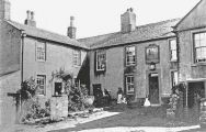
The Robin Hood, early 20th century / Routledge, Alan W., compil. Whitehaven & Around from Old Photographs (Stroud, Gloucestershire, 2016) (ebook).
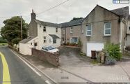
The former Robin Hood / Google Earth StreetView.
"th" can not be assigned to a declared number type with value 19.