
Robin Hood (Distington): Difference between revisions
m (Text replacement - "AdmDiv" to "AdministrativeDivision") |
m (Text replacement - "PnItemTop" to "PlaceNamesItemTop") |
||
| Line 1: | Line 1: | ||
__NOTOC__{{ | __NOTOC__{{PlaceNamesItemTop|Lat=54.584665|Lon=-3.549601|AdministrativeDivision=Cumberland|Vicinity=''c.'' 1.8 km SSW of Distington|Type=Public house|Interest=Robin Hood name|Status=Defunct|Demonym=|Riding=|GreaterLondon=|Year=1839|Aka=|Century=|Cluster1=|Cluster2=|Cluster3=|Image=google-earth-robin-hood-p-h-distington.jpg|Postcards=|ExtraCat1=|ExtraCat2=|ExtraCat3=|ExtraCat4=|ExtraCat5=|ExtraLink1=|ExtraLink2=|ExtraLink3=|ExtraLink4=|ExtraLink5=|ExtraLinkName1=|ExtraLinkName2=|ExtraLinkName3=|ExtraLinkName4=|ExtraLinkName5=|GeopointPrefix=|GeopointSuffix=|StatusSuffix=|DatePrefix=|DateSuffix=}} | ||
{{#display_map:{{#var:Coords}}~{{#replace:{{PAGENAME}}|'|'}}|width=34%|enablefullscreen=yes}}<div class="pnMapLegend">The former Robin Hood.</div> | {{#display_map:{{#var:Coords}}~{{#replace:{{PAGENAME}}|'|'}}|width=34%|enablefullscreen=yes}}<div class="pnMapLegend">The former Robin Hood.</div> | ||
[[File:google-earth-robin-hood-p-h-distington.jpg|thumb|right|500px|Former Robin Hood / Google Earth Street View.]]<div class="no-img"> | [[File:google-earth-robin-hood-p-h-distington.jpg|thumb|right|500px|Former Robin Hood / Google Earth Street View.]]<div class="no-img"> | ||
Revision as of 23:56, 5 January 2021
| Locality | |
|---|---|
| Coordinate | 54.584665, -3.549601 |
| Adm. div. | Cumberland |
| Vicinity | c. 1.8 km SSW of Distington |
| Type | Public house |
| Interest | Robin Hood name |
| Status | Defunct |
| First Record | 1839 |

By Henrik Thiil Nielsen, 2017-02-23. Revised by Henrik Thiil Nielsen, 2021-01-05.
The Robin Hood, a.k.a. the Robin Hood Inn, c. 1.8 km SSW of Distington, is indicated on a map in an 1839 book on the Lake District.[1] It was in existence at least as late as 1947.[2] In 1901 it was run by a William Crone.[3] While the former pub now seems to be a family home, it is (also) listed as a small business under the name of Robin Hood Cottage.[4]Template:PnItemQry
Gazetteers
- Not included in Dobson, R. B., ed.; Taylor, J., ed. Rymes of Robyn Hood: an Introduction to the English Outlaw (London, 1976), pp. 293-311.
Sources
- Routledge, Alan W., compil. Whitehaven & Around from Old Photographs (Stroud, Gloucestershire, 2016) (ebook).
Maps
- Ford, William. A Description of the Scenery in the Lake District, intended as a Guide to Strangers (Carlisle, 1839), frontis.
- 6" O.S. map Cumberland LXI (1867; surveyed 1861-64)
- 6" O.S. map Cumberland LXI.SE (1867; rev. 1861-64) (georeferenced)
- 6" O.S. map Cumberland LXI (1900; rev. 1898)
- 6" O.S. map Cumberland LXI (1926; rev. 1923)
- 6" O.S. map Cumberland LXI (c. 1947; rev. 1938)
- 6" O.S. map Cumberland LXI (1951; rev. 1947).
Background
Notes
- ↑ Ford, William. A Description of the Scenery in the Lake District, intended as a Guide to Strangers (Carlisle, 1839), frontis.
- ↑ 6" O.S. map Cumberland LXI (1951; rev. 1947).
- ↑ Routledge, Alan W., compil. Whitehaven & Around from Old Photographs (Stroud, Gloucestershire, 2016) (ebook).
- ↑ Addresses & Postcodes: Robin Hood Cottage, Distington.
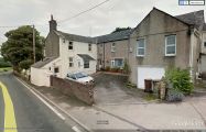
Former Robin Hood / Google Earth Street View.
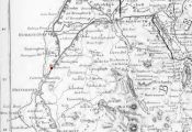
Robin Hood indicated with a red dot on this 1839 map / Ford, William. A Description of the Scenery in the Lake District, intended as a Guide to Strangers (Carlisle, 1839), frontis. (Click to enlarge).
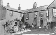
Robin Hood, early 20th century / Routledge, Alan W., compil. Whitehaven & Around from Old Photographs (Stroud, Gloucestershire, 2016) (ebook).

