
Robin Hood (Distington): Difference between revisions
mNo edit summary |
m (Text replacement - "Google Earth StreetView" to "Google Earth Street View") |
||
| Line 3: | Line 3: | ||
[[File:william-ford-1839a-map.jpg|thumb|right|500px|The Robin Hood is shown on this 1839 map near the point I have indicated with a red dot / {{:Ford, William 1839a}}, frontis.]] | [[File:william-ford-1839a-map.jpg|thumb|right|500px|The Robin Hood is shown on this 1839 map near the point I have indicated with a red dot / {{:Ford, William 1839a}}, frontis.]] | ||
[[File:routledge-alan-w-2016a.jpg|thumb|right|500px|The Robin Hood, early 20th century / {{:Routledge, Alan W 2016a}} (ebook).]] | [[File:routledge-alan-w-2016a.jpg|thumb|right|500px|The Robin Hood, early 20th century / {{:Routledge, Alan W 2016a}} (ebook).]] | ||
[[File:google-earth-robin-hood-p-h-distington.jpg|thumb|right|500px|The former Robin Hood / Google Earth | [[File:google-earth-robin-hood-p-h-distington.jpg|thumb|right|500px|The former Robin Hood / Google Earth Street View.]] | ||
<p id="byline">By Henrik Thiil Nielsen, 2017-02-23. Revised by {{#realname:{{REVISIONUSER}}}}, {{REVISIONYEAR}}-{{REVISIONMONTH}}-{{REVISIONDAY2}}.</p><div class="no-img"> | <p id="byline">By Henrik Thiil Nielsen, 2017-02-23. Revised by {{#realname:{{REVISIONUSER}}}}, {{REVISIONYEAR}}-{{REVISIONMONTH}}-{{REVISIONDAY2}}.</p><div class="no-img"> | ||
The Robin Hood, a.k.a. the Robin Hood Inn, ''c.'' 1.8 km SSW of Distington, is indicated on a map in an 1839 book on the Lake District.<ref>{{:Ford, William 1839a}}, frontis.</ref> It was in existence at least as late as 1947.<ref>[http://maps.nls.uk/view/101092414#zoom=5&lat=5634&lon=2588&layers=BT 6" O.S. map ''Cumberland'' LXI (1951; rev. 1947).]</ref> In 1901 it was run by a William Crone.<ref>{{:Routledge, Alan W 2016a}} (ebook).</ref> While the former pub now seems to be a family home (see Google Earth | The Robin Hood, a.k.a. the Robin Hood Inn, ''c.'' 1.8 km SSW of Distington, is indicated on a map in an 1839 book on the Lake District.<ref>{{:Ford, William 1839a}}, frontis.</ref> It was in existence at least as late as 1947.<ref>[http://maps.nls.uk/view/101092414#zoom=5&lat=5634&lon=2588&layers=BT 6" O.S. map ''Cumberland'' LXI (1951; rev. 1947).]</ref> In 1901 it was run by a William Crone.<ref>{{:Routledge, Alan W 2016a}} (ebook).</ref> While the former pub now seems to be a family home (see Google Earth Street View photo below), it is (also) listed as a small business under the name of Robin Hood Cottage.<ref> [http://www.addressesandpostcodes.co.uk/address/3UUuwTm9/robin-hood-cottage-distington-workington-ca14-5sh.html Addresses & Postcodes: Robin Hood Cottage, Distington.]</ref> | ||
<!--=== Allusions === | <!--=== Allusions === | ||
{{#ask:[[Category:Allusions (_PLACE-NAME)]]|format=embedded|embedformat=h4|columns=1|limit=1000|sort=Utitle}}--> | {{#ask:[[Category:Allusions (_PLACE-NAME)]]|format=embedded|embedformat=h4|columns=1|limit=1000|sort=Utitle}}--> | ||
| Line 35: | Line 35: | ||
File:william-ford-1839a-map.jpg|thumb|right|500px|The Robin Hood is shown on this 1839 map near the point I have indicated with a red dot / {{:Ford, William 1839a}}, frontis. | File:william-ford-1839a-map.jpg|thumb|right|500px|The Robin Hood is shown on this 1839 map near the point I have indicated with a red dot / {{:Ford, William 1839a}}, frontis. | ||
File:routledge-alan-w-2016a.jpg|thumb|right|500px|The Robin Hood, early 20th century / {{:Routledge, Alan W 2016a}} (ebook). | File:routledge-alan-w-2016a.jpg|thumb|right|500px|The Robin Hood, early 20th century / {{:Routledge, Alan W 2016a}} (ebook). | ||
File:google-earth-robin-hood-p-h-distington.jpg|thumb|right|500px|The former Robin Hood / Google Earth | File:google-earth-robin-hood-p-h-distington.jpg|thumb|right|500px|The former Robin Hood / Google Earth Street View. | ||
</gallery> | </gallery> | ||
{{PnItemNav}} | {{PnItemNav}} | ||
Revision as of 18:18, 4 December 2017


By Henrik Thiil Nielsen, 2017-02-23. Revised by Henrik Thiil Nielsen, 2017-12-04.
The Robin Hood, a.k.a. the Robin Hood Inn, c. 1.8 km SSW of Distington, is indicated on a map in an 1839 book on the Lake District.[1] It was in existence at least as late as 1947.[2] In 1901 it was run by a William Crone.[3] While the former pub now seems to be a family home (see Google Earth Street View photo below), it is (also) listed as a small business under the name of Robin Hood Cottage.[4]
Gazetteers
- Not included in Dobson, R. B., ed.; Taylor, J., ed. Rymes of Robyn Hood: an Introduction to the English Outlaw (London, 1976), pp. 293-311.
Sources
- Routledge, Alan W., compil. Whitehaven & Around from Old Photographs (Stroud, Gloucestershire, 2016) (ebook).
Maps
- Ford, William. A Description of the Scenery in the Lake District, intended as a Guide to Strangers (Carlisle, 1839), frontis.
- 6" O.S. map Cumberland LXI (1867; surveyed 1861-64)
- 6" O.S. map Cumberland LXI.SE (1867; rev. 1861-64) (georeferenced)
- 6" O.S. map Cumberland LXI (1900; rev. 1898)
- 6" O.S. map Cumberland LXI (1926; rev. 1923)
- 6" O.S. map Cumberland LXI (c. 1947; rev. 1938)
- 6" O.S. map Cumberland LXI (1951; rev. 1947).
Background
Also see
Notes
- ↑ Ford, William. A Description of the Scenery in the Lake District, intended as a Guide to Strangers (Carlisle, 1839), frontis.
- ↑ 6" O.S. map Cumberland LXI (1951; rev. 1947).
- ↑ Routledge, Alan W., compil. Whitehaven & Around from Old Photographs (Stroud, Gloucestershire, 2016) (ebook).
- ↑ Addresses & Postcodes: Robin Hood Cottage, Distington.
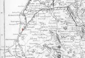
The Robin Hood is shown on this 1839 map near the point I have indicated with a red dot / Ford, William. A Description of the Scenery in the Lake District, intended as a Guide to Strangers (Carlisle, 1839), frontis.
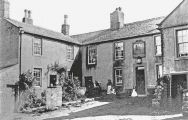
The Robin Hood, early 20th century / Routledge, Alan W., compil. Whitehaven & Around from Old Photographs (Stroud, Gloucestershire, 2016) (ebook).
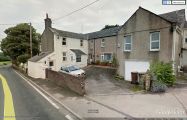
The former Robin Hood / Google Earth Street View.