
Robin Hood (Congleton): Difference between revisions
m (Text replacement - "No Copy in NLS" to "No copy in NLS") |
mNo edit summary |
||
| Line 1: | Line 1: | ||
__NOTOC__{{PlaceNamesItemTop|Lat=53.179617|Lon=-2.171355|AdministrativeDivision=Cheshire|Vicinity=Buxton Road (A54), Buglawton, Congleton|Type=Public house|Interest=Robin Hood name|Status=Defunct|Demonym=|Riding=|GreaterLondon=|Year= | __NOTOC__{{PlaceNamesItemTop|Lat=53.179617|Lon=-2.171355|AdministrativeDivision=Cheshire|Vicinity=Buxton Road (A54), Buglawton, Congleton|Type=Public house|Interest=Robin Hood name|Status=Defunct|Demonym=|Riding=|GreaterLondon=|Year=1850|Aka=Robin Hood Inn|Century=|Cluster1=|Cluster2=|Cluster3=|Image=rh-congleton-google-earth.jpg|Postcards=|ExtraCat1=|ExtraCat2=|ExtraCat3=|ExtraCat4=|ExtraCat5=|ExtraLink1=|ExtraLink2=|ExtraLink3=|ExtraLink4=|ExtraLink5=|ExtraLinkName1=|ExtraLinkName2=|ExtraLinkName3=|ExtraLinkName4=|ExtraLinkName5=|GeopointPrefix=|GeopointSuffix=|StatusSuffix=|DatePrefix=|DateSuffix=}} | ||
{{#display_map:{{#var:Coords}}~{{#replace:{{PAGENAME}}|'|'}}|width=34%|enablefullscreen=yes}}<div class="pnMapLegend">The Robin Hood in Congleton.</div> | {{#display_map:{{#var:Coords}}~{{#replace:{{PAGENAME}}|'|'}}|width=34%|enablefullscreen=yes}}<div class="pnMapLegend">The Robin Hood in Congleton.</div> | ||
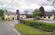
[[File:rh-congleton-google-earth.jpg|thumb|right|500px|The Robin Hood on Buxton Road, Buglawton, Congleton / Google Maps Street View.]]<div class="no-img"> | [[File:rh-congleton-google-earth.jpg|thumb|right|500px|The Robin Hood on Buxton Road, Buglawton, Congleton / Google Maps Street View.]]<div class="no-img"> | ||
| Line 5: | Line 5: | ||
The Robin Hood on Buxton Road (A54) in Buglawton, Congleton, dated from the 18th century<ref>[http://www.macclesfieldcanal.org.uk/robinhood.htm The Macclesfield Canal: Robin Hood Inn.]</ref> It closed at some point between 2018 and November 2020. | The Robin Hood on Buxton Road (A54) in Buglawton, Congleton, dated from the 18th century<ref>[http://www.macclesfieldcanal.org.uk/robinhood.htm The Macclesfield Canal: Robin Hood Inn.]</ref> It closed at some point between 2018 and November 2020. | ||
The first dated record IRHB has found so far is a 6" O.S. map of the area published 1882, based on surveying done in 1871-73. On this and later maps listed below, the pub is labelled 'Robin Hood Inn'. | The first dated record IRHB has found so far is an 1850 directory which mentions 'Wilbraham Egerton, Esq., the present proprietor [of the manor of Buglawton], who holds a Court Leet and Baron at the Robin Hood Inn'.<ref>[http://specialcollections.le.ac.uk/digital/collection/p16445coll4/id/304393 University of Leicester: Special Collections Online: History, Gazetteer & Directory of Cheshire, 1850 - Page 418.]</ref> The pub is also included on a 6" O.S. map of the area published 1882, based on surveying done in 1871-73. On this and later maps listed below, the pub is labelled 'Robin Hood Inn'. | ||
{{PlaceNamesItemAllusionsAndRecords}} | {{PlaceNamesItemAllusionsAndRecords}} | ||
== Gazetteers == | == Gazetteers == | ||
* Not included in {{:Dobson, Richard Barrie 1976a}}, pp. 293-311 | * Not included in {{:Dobson, Richard Barrie 1976a}}, pp. 293-311 | ||
* Not included in {{:Dodgson, John McNeal 1970a}}. | * Not included in {{:Dodgson, John McNeal 1970a}}. | ||
== Sources == | |||
* [http://specialcollections.le.ac.uk/digital/collection/p16445coll4/id/304393 University of Leicester: Special Collections Online: History, Gazetteer & Directory of Cheshire, 1850 - Page 418.] | |||
== Maps == | == Maps == | ||
Revision as of 13:04, 18 June 2021
| Locality | |
|---|---|
| Coordinate | 53.179617, -2.171355 |
| Adm. div. | Cheshire |
| Vicinity | Buxton Road (A54), Buglawton, Congleton |
| Type | Public house |
| Interest | Robin Hood name |
| Status | Defunct |
| First Record | 1850 |
| A.k.a. | Robin Hood Inn |

By Henrik Thiil Nielsen, 2013-08-07. Revised by Henrik Thiil Nielsen, 2021-06-18.
The Robin Hood on Buxton Road (A54) in Buglawton, Congleton, dated from the 18th century[1] It closed at some point between 2018 and November 2020.
The first dated record IRHB has found so far is an 1850 directory which mentions 'Wilbraham Egerton, Esq., the present proprietor [of the manor of Buglawton], who holds a Court Leet and Baron at the Robin Hood Inn'.[2] The pub is also included on a 6" O.S. map of the area published 1882, based on surveying done in 1871-73. On this and later maps listed below, the pub is labelled 'Robin Hood Inn'.
Gazetteers
- Not included in Dobson, R. B., ed.; Taylor, J., ed. Rymes of Robyn Hood: an Introduction to the English Outlaw (London, 1976), pp. 293-311
- Not included in Dodgson, John McN.; Rumble, Alexander R. The Place-Names of Cheshire, pts. I-V (English Place-Name Society, vols. XLIV-XLVIII, LIV, LXXIV) (Cambridge, 1970-72; [s.l.], 1981; Nottingham, 1997).
Sources
Maps
- 25" O.S. map Cheshire XLIII.15 (c. 1872; surveyed c. 1870). No copy in NLS
- 25" O.S. map Cheshire XLIII.15 (1897; rev. 1896)
- 25" O.S. map Staffordshire III.2 (1899; rev. 1897) (georeferenced)
- 25" O.S. map Cheshire XLIII.15 (1909; rev. 1907)
- 6" O.S. map Cheshire XLIII (1882; surveyed 1871–73)
- 6" O.S. map Staffordshire III.NW (1888; surveyed 1871–78)
- 6" O.S. map Cheshire XLIII.SE (1899; rev. 1896–97)
- 6" O.S. map Cheshire XLIII.SE (1899; rev. 1896–97) (georeferenced)
- 6" O.S. map Staffordshire III.NW (1900; rev. 1897)
- 6" O.S. map Cheshire XLIII.SE (1912; rev. 1907)
- 6" O.S. map Staffordshire III.NW (1926; rev. 1922)
- 6" O.S. map Cheshire XLIII.SE (c. 1945; rev. 1938)
- 6" O.S. map Staffordshire III.NW (c. 1950; rev. 1945).
Background
- Facebook: Robin Hood, Buglawton
- The Macclesfield Canal: Robin Hood Inn
- Pub website, archived at the Wayback Machine, 11 Aug. 2018.
Notes
Image gallery
Click any image to display it in the lightbox, where you can navigate between images by clicking in the right or left side of the current image.
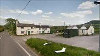
When the Robin Hood was still in business / Google Maps Street View.
The Robin Hood in May 2019 / Google Maps Street View.
