
Robin Hood (Congleton): Difference between revisions
From International Robin Hood Bibliography
m (Text replacement - "PnItemQry" to "PlaceNamesItemQuery") |
m (Text replacement - "PnItemNav" to "PlaceNamesItemNavigation") |
||
| Line 41: | Line 41: | ||
</gallery> | </gallery> | ||
{{ | {{PlaceNamesItemNavigation}} | ||
Revision as of 00:22, 6 January 2021
| Locality | |
|---|---|
| Coordinate | 53.179617, -2.171355 |
| Adm. div. | Cheshire |
| Vicinity | Buxton Road (A54), Buglawton, Congleton |
| Type | Public house |
| Interest | Robin Hood name |
| Status | Defunct |
| First Record | 1882 |
The Robin Hood in Congleton.

By Henrik Thiil Nielsen, 2013-08-07. Revised by Henrik Thiil Nielsen, 2021-01-06.
The Robin Hood on Buxton Road (A54) in Buglawton, Congleton, dated from the 18th century[1] It closed at some point between 2018 and November 2020.
The first dated record IRHB has found so far is a 6" O.S. map of the area published 1882, based on surveying done in 1871-73. On this and later maps listed below, the pub is labelled 'Robin Hood Inn'. Template:PlaceNamesItemQuery
Gazetteers
- Not included in Dobson, R. B., ed.; Taylor, J., ed. Rymes of Robyn Hood: an Introduction to the English Outlaw (London, 1976), pp. 293-311
- Not included in Dodgson, John McN.; Rumble, Alexander R. The Place-Names of Cheshire, pts. I-V (English Place-Name Society, vols. XLIV-XLVIII, LIV, LXXIV) (Cambridge, 1970-72; [s.l.], 1981; Nottingham, 1997).
Maps
- 25" O.S. map Cheshire XLIII.15 (c. 1872; surveyed c. 1870). No Copy in NLS
- 25" O.S. map Cheshire XLIII.15 (1897; rev. 1896)
- 25" O.S. map Staffordshire III.2 (1899; rev. 1897) (georeferenced)
- 25" O.S. map Cheshire XLIII.15 (1909; rev. 1907)
- 6" O.S. map Cheshire XLIII (1882; surveyed 1871–73)
- 6" O.S. map Staffordshire III.NW (1888; surveyed 1871–78)
- 6" O.S. map Cheshire XLIII.SE (1899; rev. 1896–97)
- 6" O.S. map Cheshire XLIII.SE (1899; rev. 1896–97) (georeferenced)
- 6" O.S. map Staffordshire III.NW (1900; rev. 1897)
- 6" O.S. map Cheshire XLIII.SE (1912; rev. 1907)
- 6" O.S. map Staffordshire III.NW (1926; rev. 1922)
- 6" O.S. map Cheshire XLIII.SE (c. 1945; rev. 1938)
- 6" O.S. map Staffordshire III.NW (c. 1950; rev. 1945).
Background
- Facebook: Robin Hood, Buglawton
- The Macclesfield Canal: Robin Hood Inn
- Pub website, archived at the Wayback Machine, 11 Aug. 2018.
Notes
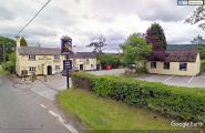
When the Robin Hood was still in business / Google Maps Street View.
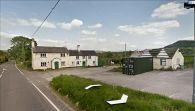
The Robin Hood in May 2019 / Google Maps Street View.
